Carterton, Oxfordshire facts for kids
Quick facts for kids Carterton |
|
|---|---|
 St John the Evangelist parish church |
|
| Population | 15,680 (2021 Census) |
| OS grid reference | SP2806 |
| • London | 72.4 miles (116.5 km) |
| Civil parish |
|
| District |
|
| Shire county | |
| Region | |
| Country | England |
| Sovereign state | United Kingdom |
| Post town | Carterton |
| Postcode district | OX18 |
| Dialling code | 01993 |
| Police | Thames Valley |
| Fire | Oxfordshire |
| Ambulance | South Central |
| EU Parliament | South East England |
| UK Parliament |
|
| Website | Carterton Community Website |
Carterton is a town in West Oxfordshire, England. It is about 4 miles (6.4 km) southwest of Witney. In 2011, about 15,769 people lived in Carterton. It is known for being close to RAF Brize Norton, a very important Royal Air Force base.
Contents
History of Carterton
How Carterton Began
Long ago, in the 1300s, much of the land where Carterton now stands belonged to the Moleyns family. Later, in the 1770s, the Duke of Marlborough owned the land.
The town of Carterton started to look like it does today in 1894. A man named William Carter bought some land. He divided it into small plots, about 6 acres each. These plots were sold for people to build homes and start small farms. Many people who moved here were retired soldiers or people from big cities.
Carterton quickly became famous for its market gardens. Farmers grew black grapes and special Carterton tomatoes. These were so good they were sold at the famous Covent Garden Market in London!
Growth with RAF Brize Norton
Carterton grew a lot because of the nearby RAF Brize Norton airbase. This base was built in 1937. It became the RAF's largest operating base. This changed Carterton from a small farming area to a busy town.
In the 1950s, many homes were built for RAF families and American service members. Carterton became a very busy and growing place. More houses were needed as the town got bigger.
Over the years, Carterton kept expanding. New housing estates were built, especially in the northeast. The town centre also changed a lot. New shops and offices were added. By 1997, the main streets were lined with many different kinds of shops. A large supermarket was built in 1998.
In the early 2000s, a new area called Shilton Park was built. This added many more homes. A new primary school and a shopping centre were also part of this plan.
Public Buildings and Services
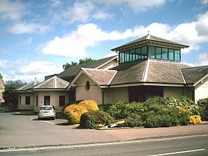
Carterton has many important public buildings and services. In the late 1960s, a new police station was built to help keep the town safe.
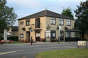
The Carterton Town Hall was built in 1982–83. It's an important place for local government. A war memorial, first put up around 1920, was moved to the new town hall.
The town has a public library where you can borrow books. There are also several places to eat and drink, like the Beehive Hotel.
RAF Brize Norton
Construction on RAF Brize Norton began in 1935. During World War II, the base grew very quickly. It became a key location for the Royal Air Force. From 1950 to 1965, the base was even used by American bomber planes.
When the RAF returned in 1965, they made Brize Norton their main base for air transport in the country. This means many important flights for the military start or end here.
Community Life
Carterton has a recreation ground that was given to the town in 1906. This is where many sports clubs started, like football, cricket, tennis, and bowls.
A new church, St John the Evangelist, was built in 1963. It replaced a smaller church as the town grew.
A new Memorial Garden has been built near the town. This garden is a special place for people to remember service members who have died. Their bodies are brought back to the UK through RAF Brize Norton.
Governance
Did you know that Theo Walcott's grandfather, Windell "Joe" Walcott, was involved in Carterton's local government? He was the council chairman from 2002 to 2006. He was also the mayor of Carterton from 2000 to 2002. He received an award called an MBE for his great work in the community.
Education
Carterton has one secondary school:
- Carterton Community College
The town also has five primary schools:
- Carterton Primary School
- Edith Moorhouse Primary School
- The Gateway Primary School
- St John the Evangelist Church of England Primary School
- St Joseph's Catholic Primary School
Media
You can get local news and TV shows from BBC South and ITV Meridian. Local radio stations include BBC Radio Oxford and Heart South. There's also Witney Radio, a local station for the community. You can read about Carterton in local newspapers like Oxford Times and Witney Gazette.
Amenities
Carterton has many shops for your everyday needs. There are also four public houses (pubs) and a public library. For groceries, you can find stores like Asda, Morrisons, and Aldi.
Sport and Leisure
If you like sports, Carterton has a Non-League football team called Carterton F.C.. They play at Kilkenny Lane. There's also a squash club and a bowls club. The town has a leisure centre with a swimming pool and several smaller gyms.
 |
Cheltenham | Burford | Brize Norton, Witney |  |
| Cirencester | Oxford | |||
| Lechlade, Swindon | Faringdon | Bampton, Wantage |
Climate
| Climate data for RAF Brize Norton (1991–2020) | |||||||||||||
|---|---|---|---|---|---|---|---|---|---|---|---|---|---|
| Month | Jan | Feb | Mar | Apr | May | Jun | Jul | Aug | Sep | Oct | Nov | Dec | Year |
| Mean daily maximum °C (°F) | 7.7 (45.9) |
8.3 (46.9) |
10.9 (51.6) |
13.9 (57.0) |
17.1 (62.8) |
20.1 (68.2) |
22.5 (72.5) |
21.9 (71.4) |
19.0 (66.2) |
14.8 (58.6) |
10.6 (51.1) |
8.0 (46.4) |
14.6 (58.3) |
| Mean daily minimum °C (°F) | 1.7 (35.1) |
1.6 (34.9) |
3.0 (37.4) |
4.8 (40.6) |
7.6 (45.7) |
10.5 (50.9) |
12.6 (54.7) |
12.5 (54.5) |
10.3 (50.5) |
7.5 (45.5) |
4.2 (39.6) |
2.0 (35.6) |
6.6 (43.9) |
| Average rainfall mm (inches) | 66.2 (2.61) |
48.1 (1.89) |
46.4 (1.83) |
49.2 (1.94) |
60.1 (2.37) |
49.8 (1.96) |
55.1 (2.17) |
58.6 (2.31) |
54.2 (2.13) |
70.9 (2.79) |
73.2 (2.88) |
74.2 (2.92) |
706.0 (27.80) |
| Average rainy days (≥ 1 mm) | 12.3 | 9.6 | 9.3 | 9.9 | 9.5 | 8.7 | 8.4 | 10.1 | 8.9 | 11.4 | 12.8 | 12.3 | 123.4 |
| Mean monthly sunshine hours | 62.6 | 81.3 | 123.2 | 171.9 | 206.1 | 209.4 | 214.7 | 193.4 | 151.5 | 111.6 | 70.8 | 55.5 | 1,652 |
| Source: Met Office | |||||||||||||
See also
 In Spanish: Carterton para niños
 | Isaac Myers |
 | D. Hamilton Jackson |
 | A. Philip Randolph |


