Castaic Junction, California facts for kids
Quick facts for kids
Castaic Junction, California
|
|
|---|---|

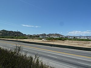
Castaic Junction as viewed from SR 126
|
|
| Country | |
| State | |
| County | |
| Elevation | 310 m (1,017 ft) |
| Time zone | UTC-8 (Pacific (PST)) |
| • Summer (DST) | UTC-7 (PDT) |
| Area code(s) | 661 |
| GNIS feature ID | 270336 |
Castaic Junction is a small community in Los Angeles County, California. It is an "unincorporated community." This means it's a place where people live, but it doesn't have its own local government like a city does. Instead, it's managed by the county.
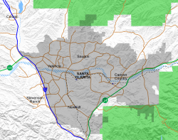
This area is important because it's where two major roads meet: Interstate 5 and State Route 126. It's also near where the Castaic Creek flows into the Santa Clara River.
Castaic Junction is very close to the City of Santa Clarita. Even though it's a separate community, places in Castaic Junction use a Valencia zip code (91355). The popular Six Flags Magic Mountain theme park is just south of this junction.
Contents
History of Castaic Junction
Early Days and Native Americans
The history of Castaic Junction goes back a long time. In 1769, a Spanish explorer named Father Juan Crespí camped near this spot. He noted that there was a "thriving Indian village" here. This shows that people lived in this area for many years before modern roads were built.
How Castaic Junction Got Its Name
The name "Castaic Junction" was first used in 1887. This was before major highways existed. At that time, a special spot was set up for trains to stop and switch tracks. This train stop was called a "railroad siding." Because it was a meeting point, or "junction," the name stuck. It was also the official southern end of the historic Ridge Route, an important early highway.
St. Francis Dam Disaster
A sad event happened near Castaic Junction in 1928. The St. Francis Dam collapsed, causing a huge flood. This powerful flood destroyed a highway bridge located at Castaic Junction. It was a major disaster for the area.
Old Train Depot and Rancho San Francisco
For many years, Castaic Junction had a cool train depot. It was built in the Art Deco−Moderne style, which was popular for its sleek, modern look. This depot served a railroad line that ran along the Santa Clara River. Trains traveled between Saugus and Piru. Sadly, the depot was torn down around 1990.
Just north of the Magic Mountain parking lot, you can find the site of an old adobe ranch house. This was part of the historic Rancho San Francisco. This large Mexican land grant covered a huge area, including the entire Santa Clarita Valley.
James Dean's Last Meal
There's a local story about the famous actor James Dean. Legend says he ate his last meal at a restaurant called Tip's. This restaurant used to be right at the crossroads of Highway 126 and The Old Road. After his meal, he drove north, heading towards his fatal car crash.
See also
 In Spanish: Castaic Junction para niños
 | Janet Taylor Pickett |
 | Synthia Saint James |
 | Howardena Pindell |
 | Faith Ringgold |


