
Castle Peak (Alaska) facts for kids
Quick facts for kids Castle Peak |
|
|---|---|

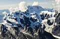
Aerial view of south aspect
|
|
| Highest point | |
| Elevation | 10,190 ft (3,110 m) |
| Prominence | 2,200 ft (670 m) |
| Isolation | 4.49 mi (7.23 km) |
| Parent peak | Mount Blackburn |
| Geography | |

Castle Peak
Location in Alaska
|
|
| Location | Wrangell-St. Elias National Park Valdez-Cordova Borough Alaska, United States |
| Parent range | Wrangell Mountains |
| Topo map | USGS McCarthy C-7 |
Castle Peak is a tall mountain in Alaska, standing at 10,190 feet (3,110 meters) high. It is part of the Wrangell Mountains. This peak is located inside the huge Wrangell–St. Elias National Park and Preserve.
Castle Peak is about 21 miles (34 km) northwest of a town called McCarthy. It is also about 9.3 miles (15 km) south of Mount Blackburn, which is a much larger mountain. The peak sits near the edge of the Kuskulana Glacier valley. Water from the mountain flows into the Kuskulana River and Lakina River. These rivers then join the Chitina River. The name "Castle Peak" was given by early gold prospectors around 1901.
Contents
Understanding Castle Peak's Climate
Castle Peak is in a subarctic climate zone. This means it has very long, cold, and snowy winters. The summers are usually cool.
How Weather Forms Here
The Gulf of Alaska is a large body of water nearby. Winds from the Gulf blow towards the Wrangell Mountains. When these winds hit the mountains, they are forced to rise. This process is called orographic lift. As the air rises, it cools down and creates a lot of rain and snow.
Temperatures and Best Visiting Times
In winter, temperatures can drop very low, sometimes below −20 °F (−29 °C). With the wind, it can feel even colder, below −30 °F (−34 °C). If you want to see or climb Castle Peak, the best time to visit is from May through June. The weather is usually most favorable then.
Images for kids
-
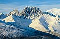
Castle Peak, north aspect
-
Castle Peak, south aspect
-
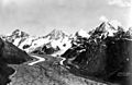
Castle Peak (right), with Kuskulana Glacier. 1924


.jpg)
