
Castro facts for kids
Quick facts for kids
Castro
|
||
|---|---|---|

Panoramic view of Castro
|
||
|
||

The Commune of Castro in Los Lagos Region
|
||
| Country | Chile | |
| Region | Los Lagos | |
| Province | Chiloé | |
| Founded as | Santiago de Castro | |
| Founded | 12 February 1567 | |
| Government | ||
| • Type | Municipality | |
| Area | ||
| • Total | 427.5 km2 (165.1 sq mi) | |
| Elevation | 130 m (430 ft) | |
| Population
(2012)
|
||
| • Total | 41,667 | |
| • Density | 97.467/km2 (252.44/sq mi) | |
| • Urban | 29,148 | |
| • Rural | 10,218 | |
| Demonym(s) | Castreño/a | |
| Sex | ||
| • Men | 19,325 | |
| • Women | 20,041 | |
| Time zone | UTC−4 (CLT) | |
| • Summer (DST) | UTC−3 (CLST) | |
| Area code(s) | 56 + 65 | |
| Climate | Cfb | |
.svg)
Castro is a city and a commune located on Chiloé Island in Chile. It's the main city of the Chiloé Province within the Los Lagos Region. Castro sits on the eastern side of Chiloé Island, right on the Estero de Castro. This spot is great because it offers easy access to the smaller islands of the Chiloé Archipelago. It also connects to the open ocean through Cucao and Huillinco to the west.
Contents
History of Castro
Castro is one of Chile's oldest cities that has been continuously lived in. It was founded on February 12, 1567. A leader named Rodrigo de Quiroga sent his son-in-law, Captain Martín Ruiz de Gamboa, to take control of Chiloé Island. They established the city of Castro and worked with the local Cunco people.
From its founding until 1767, Castro was the main administrative center for Chiloé Island. By 1594, about 8,000 people lived in Castro, mostly farmers. The town was attacked and looted by Dutch pirates several times in the mid-1600s.
In 1767, during a time when Spain was trying to modernize its empire, Chiloé Island became directly controlled by the Viceroyalty of Peru. To make it easier to communicate with Lima, the capital of the archipelago was moved from Castro to Ancud that same year. Even after Chiloé joined the Republic of Chile, Ancud remained the capital.
Castro faced challenges over the years. An earthquake destroyed much of the city in 1837. By 1907, only 1,243 people lived there. Things started to improve after a railway line to Ancud opened in 1912. However, a huge earthquake and tsunami in 1960 destroyed or damaged many buildings. This included the railway station, the town hall, and many traditional wooden palafitos houses. In 1960, Castro had 7,000 residents. It wasn't until 1982 that Castro became the capital of the Chiloé Archipelago again.
People and Population
According to a 2002 survey by the National Statistics Institute, Castro covers an area of 427.5 square kilometers. It had 39,366 people living there at that time. This included 19,325 men and 20,041 women.
Most people, about 29,148 (74%), lived in the city areas. The remaining 10,218 people (26%) lived in the countryside. The population of Castro grew quite a bit between 1992 and 2002, increasing by 31.5%.
How Castro is Governed
Castro is a "commune," which is a local government area in Chile. It's managed by a municipal council. The council is led by an alcalde, who is like a mayor. The alcalde is chosen directly by the people every four years.
What to See in Castro
Castro is famous for its unique sights, especially its traditional buildings and beautiful churches.
- Palafitos

One of the most famous things about Castro is its palafitos. These are traditional wooden stilt houses built over the water. You can still see many of them in the Gamboa district, which is in the western part of town. This area is located in a bay called Fiordo de Castro. Near these houses, you can also see boats being built in the traditional way at a wharf. There's even an interesting wooden chapel in Gamboa.
- Plaza de Armas
The Plaza de Armas is the main town square. It has a lovely, well-kept park. The city's government building, the Municipality, and the beautiful Church of San Francisco are all located here. This square has always been the heart of Castro. Many shops, banks, cafes, and restaurants surround it.
- Museums
If you like learning about history and art, Castro has two museums. The Regional Museum of Castro (Museo Regional de Castro) shows many items made in Chiloé. It also has displays about the local culture and old artifacts. The Museum of Modern Art of Chiloé (Museo de Arte Moderno de Chiloé) was started in 1988. It has a large collection of modern art.
- Plazuela del Tren

There's a small park called Plazuela del Tren near the harbor. This park used to be a railway yard. You can see an old locomotive and other railway vehicles and machines here. They remind visitors of the railway line that connected Castro to Ancud from 1912 to 1960.
- Churches of Nercón

Nercón is a village that became part of Castro in 2007. It has another beautiful church called Nuestra Senora de Gracia. This church was built between 1886 and 1890 using Nothofagus dombeyi wood. It's so special that UNESCO declared it a World Heritage Site. You can also see a lovely garden in front of it. Between Nercón and Castro, near the bridge over the Nercón River, there's a small chapel with special offerings called ex-votoes. Close by, boats are still made from larch wood at a small wharf.
Old Forts of Castro
During the time when Chile was a Spanish colony, Castro had a small system of forts. These included Fuerte de Castro, Batería marítima de Castro, and Fortín de Tauco. Fortín de Tauco is a few kilometers south of the city, along the Estero de Castro. Today, you can only find the remains of Fortín de Tauco. The other two forts, which were located within what is now Castro city, no longer have any visible traces.
Images for kids
-
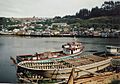
Wharf in Gamboa
-
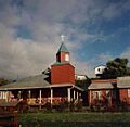
Wooden chapel in Gamboa


See also
 In Spanish: Castro para niños
