
Caswell Beach, North Carolina facts for kids
Quick facts for kids
Caswell Beach, North Carolina
|
|
|---|---|

Caswell Beach–Oak Island Lighthouse
|
|
| Motto(s):
The Best Little Beach Town in America
|
|

Caswell Beach, North Carolina
Location in North Carolina
|
|
| Country | United States |
| State | North Carolina |
| County | Brunswick |
| Area | |
| • Total | 4.10 sq mi (10.62 km2) |
| • Land | 2.97 sq mi (7.69 km2) |
| • Water | 1.13 sq mi (2.93 km2) |
| Elevation | 0 ft (0 m) |
| Population
(2020)
|
|
| • Total | 395 |
| • Density | 133.04/sq mi (51.37/km2) |
| Time zone | UTC-5 (Eastern (EST)) |
| • Summer (DST) | UTC-4 (EDT) |
| ZIP code |
28465
|
| Area codes | 910, 472 |
| FIPS code | 37-10960 |
| GNIS feature ID | 2406237 |
Caswell Beach is a small, sunny town right on the Atlantic Ocean in North Carolina, USA. It's located on the eastern part of Oak Island, near the Cape Fear River. In 2020, about 395 people lived there.
This town is known for a few cool spots. You can find Fort Caswell, a historic fort from the Civil War era. There's also the Oak Island Lighthouse, which stands tall next to the Oak Island Coast Guard Station. If you love golf, the Oak Island Golf Club is the only business in town and a great place to play. Caswell Beach is part of the larger Wilmington area.
Contents
History of Caswell Beach
Caswell Beach became an official town in 1975. Both the town and Fort Caswell are named after Richard Caswell, who was North Carolina's first governor.
Fort Caswell's Past
Fort Caswell was built way back in 1825. Today, it's a Christian retreat and conference center called the North Carolina Baptist Assembly. In 2013, it was recognized as a National Historic District because of its importance.
The Oak Island Lighthouse
The Oak Island Lighthouse started working in 1958. The town of Caswell Beach took ownership of it in 2004. It's a famous landmark on the island.
Growing as a Vacation Spot
Over the years, Caswell Beach slowly grew into a popular vacation place. However, the beach often lost sand due to strong storms like hurricanes. This erosion threatened the main road and even some houses.
To fix this, the town worked hard to protect the beach. They put in sand fences and planted special grasses called sea oats. This helped a lot, especially when the Wilmington Harbor Channel Project added a lot of sand to the beach. Because of these efforts, Caswell Beach won a national award in 2002 for being the "Best Restored Beach."
Geography and Location

Caswell Beach is located on the east end of Oak Island. It's about halfway between Wilmington, North Carolina and Myrtle Beach, South Carolina. Oak Island itself was formed in the late 1930s when the Intracoastal Waterway (ICW) was dug. The town's land area is about 2.9 square miles (7.6 km2).
Weather and Climate

Summers in Caswell Beach are warm and humid, with average temperatures around 85°F (29°C). Sea breezes often keep the beach cool. Winters are mild, usually in the 50s°F (10-15°C), but there can be short cold periods. It rains throughout the year, with about 57 inches (145 cm) of rain annually. Almost half of this rain falls between June and September.
Tropical storms and hurricanes are a concern, especially in late summer and early fall. For example, Hurricane Hazel in 1954 destroyed many houses on Oak Island. Between 1996 and 1999, four major hurricanes (Bertha, Fran, Bonnie, and Floyd) hit the area. More recently, Hurricane Matthew in 2016 damaged the sand dunes, and Hurricane Florence in 2018 caused severe flooding and wind damage.
People of Caswell Beach
| Historical population | |||
|---|---|---|---|
| Census | Pop. | %± | |
| 1980 | 110 | — | |
| 1990 | 175 | 59.1% | |
| 2000 | 370 | 111.4% | |
| 2010 | 398 | 7.6% | |
| 2020 | 395 | −0.8% | |
In 2020, about 395 people lived in Caswell Beach. Most residents are older, with an average age of 63. There are more women than men living in the town. While only a few people live there full-time, the population can grow to about 2,000 in the summer. Many families visit and rent vacation homes during this time.
Where People Live
You'll find large single-family homes along the beach, many of which are rented out to vacationers. On the west side of town, there are condo units called Oak Island Beach Villas. Most full-time residents live near the golf course in different types of homes. These include single-family homes in areas like the Arboretum, patio homes and condos in Caswell Dunes, and various housing types in Ocean Greens.
Fun Things to Do
The Beach
Caswell Beach has a three-mile-long beach that faces south. To protect it from erosion, the town has added sand to the beach several times. This beach is also a nesting area for sea turtles. The town has a strong program to protect the dunes and plant sea oats, which helps both the turtles and protects the town from storm damage. There are 12 walkways to access the beach, and most have ramps for wheelchairs.

Golf Course

The Oak Island Golf Club has an 18-hole course that is open to everyone. It's a challenging course with many sand traps and water features. The course was designed by George Cobb, who also helped design a course at Augusta National. You can practice your swing at their driving range, putting green, and sand traps.
The Lighthouse

The Oak Island Lighthouse grounds are open to the public all year for viewing and taking pictures. You can park for a short time at the base of the tower. During the summer, you can even take tours inside the lighthouse, with special appointments for tours to the very top. The lighthouse's light is maintained by the Coast Guard, while a group of citizens called "Friends of Oak Island Lighthouse" takes care of the building.
Fort Caswell

You can visit Fort Caswell to a certain extent. It's now a Christian retreat center. During the Civil War, it helped defend the coast. Later, it was used for army training in World War I and as a patrol base in World War II. Exploring its old forts and batteries is a great way to learn about US history. There's also the Fort Caswell Rifle Range nearby, where soldiers practiced shooting in World War I.

Natural Wildlife

Caswell Beach has beautiful salt and fresh water marshes and a maritime forest. These areas are home to many different plants and animals. You might see alligators, turtles, foxes, deer, raccoons, beavers, eagles, brown pelicans, and herons. Sometimes, a bear might even swim across the Intracoastal Waterway to visit! The forest has trees like live oak, Longleaf Pine, and Yaupon Holly. You can also find pretty plants like Azaleas and Sweet Bay Magnolia.
Nearby Communities
Oak Island
The town of Oak Island covers the rest of the island. It has a post office, a library branch, supermarkets, gas stations, and many restaurants. You can also find two fishing piers there.
Southport
Just across the Intracoastal Waterway is the city of Southport, with about 3,700 people. It was founded in 1792. Southport hosts the North Carolina Fourth of July Festival and has been a filming location for many movies, like Safe Haven. The "Old Southport" area has many historic houses and buildings, including Fort Johnston. On the waterfront, you can visit the North Carolina Maritime Museum at Southport. There's also a ferry that offers scenic trips across the Cape Fear River to the NC Aquarium and the Civil War battleground at Fort Fisher.
Images for kids
-
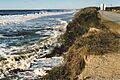
Beach Erosion–1998
-
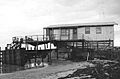
Beachfront property after 1998 Nor'easter

.jpg)
See also
 In Spanish: Caswell Beach (Carolina del Norte) para niños
