Cathedral Gorge State Park facts for kids
Quick facts for kids Cathedral Gorge State Park |
|
|---|---|

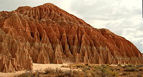
Columns and spires eroded into a bentonite formation
|
|
| Location | Lincoln County, Nevada, United States |
| Nearest town | Panaca, Nevada |
| Area | 1,792.24 acres (7.2529 km2) |
| Elevation | 4,819 ft (1,469 m) |
| Designation | Nevada state park |
| Established | 1935 |
| Administrator | Nevada Division of State Parks |
| Website | Cathedral Gorge State Park |
Cathedral Gorge State Park is an amazing place in Lincoln County, Nevada, where you can explore a dramatic landscape. It's a special area that protects over 1,600 acres (650 ha) of soft bentonite clay formations. These formations have been shaped by nature over a very long time. The park is located along U.S. Route 93, about two miles (3.2 km) northwest of the town of Panaca.
History of Cathedral Gorge
People have enjoyed picnicking at this site since the 1800s, when it was known as Cathedral Gulch. In the 1920s, the unique landscape was even used as a backdrop for outdoor plays and yearly Easter events.
In 1924, Governor James Scrugham started working to protect this beautiful area. It officially became one of Nevada's first four state parks in 1935. A group called the Civilian Conservation Corps (CCC) helped build picnic spots that are still used today. They also built a stone water tower and restroom, which are no longer in use.
Natural Wonders of the Park
What's the Weather Like?
Cathedral Gorge State Park sits about 4,800 feet (1,500 m) above sea level. The weather here is usually dry. Summers are warm, with temperatures often reaching around 95 °F (35 °C) during the day and cooling down to about 55 °F (13 °C) at night. Winters can be quite cold. Rain doesn't fall often, but thunderstorms are common.
How the Canyons Were Formed
Millions of years ago, during the Pliocene Era, a large freshwater lake covered most of Meadow Valley Wash. The colorful canyons you see at Cathedral Gorge today are what's left of this ancient lakebed.
Over a very long time, the lake slowly dried up. Then, rain and melting snow began to carve away at the soft dirt and rocks that were once the lake bottom. Tiny cracks and fissures grew into larger gullies and canyons, creating the amazing shapes you see today. This process is called Erosion.
Plants You Might See
It's hard for plants to grow in the constantly eroding clay areas of the park. However, in other parts of the park, different types of soil allow many plants to thrive.
In the sandy areas, you'll find wildflowers like dune primroses and Indian ricegrass. These plants help keep the sand dunes from blowing away. In the middle of the valley, where clay, sand, and gravel mix, the soil is rich. Here, you might see narrowleaf yucca, juniper trees, sagebrush, greasewood, white sage, shadscale, and four-winged saltbush.
Rabbitbrush often grows along roadsides and walkways. Not many types of cactus can survive here because the temperatures can drop below freezing in winter and rise above 100 °F (38 °C) in summer. Some trees, not originally from the park, have been planted around the campground to provide shade.
Animals Living in the Park
Most of the animals in Cathedral Gorge are small mammals. You might spot black-tailed jackrabbits, cottontail rabbits, coyotes, gophers, kangaroo rats, kit foxes, mice, and skunks. Sometimes, Deer can be seen near Miller Point in the late fall and winter.
Many birds fly around the camp areas and in thick bushes. Some native birds include blackbirds, black-throated sparrows, finches, American kestrels, small hawks, ravens, roadrunners, American robins, and sapsuckers. You might also see European starlings. Migratory birds that visit include bluebirds, cedar waxwings, hummingbirds, and warblers.
There are also many types of non-poisonous snakes and lizards. In the summer, you might even see a Great Basin rattlesnake.
Fun Things to Do and See
The park is famous for its very narrow slot canyons, which locals sometimes call "caves." These canyons were carved out of the mud that was at the bottom of the ancient lake. You can crawl through these tunnels and find hidden chambers, which offer a cool escape from the summer heat.
| Trail Name | Length (one-way, unless loop) |
What to Expect |
|---|---|---|
| Bullionville Trail | 0.2 miles (0.3 km) | An easy walk from the visitor center to the Bullionville Cemetery. |
| Nature Loop | 0.5 miles (0.8 km) | Starts at the campground and leads to the slot canyons. It crosses two washes and has signs explaining nature. |
| Juniper Draw Loop | 3 miles (4.8 km) | A flat, sandy loop that goes around the valley floor and its formations. |
| Miller Point Trail | 1 mile (1.6 km) | A moderate canyon trail with stairs that leads up to Miller Point. |
| Eagle Point Trail | 0.8 miles (1.3 km) | Follows a ridge line to give you a high-up view of the whole park. |
| New Ridge-line Trail | 4.2 miles (6.8 km) | This trail splits from the Juniper Draw Trail, goes through formations, and then follows the ridge line around the park. |
The park also has a campground with 22 sites, including some that are accessible for people with disabilities. There's also a group use area, restrooms, and showers. At the park entrance, you'll find a visitor center with displays and information about other parks in the area.
 | Mary Eliza Mahoney |
 | Susie King Taylor |
 | Ida Gray |
 | Eliza Ann Grier |


