
Cathedral Rock (Washington) facts for kids
Quick facts for kids Cathedral Rock |
|
|---|---|

Cathedral Rock
|
|
| Highest point | |
| Elevation | 6,724 ft (2,049 m) |
| Prominence | 1,084 ft (330 m) |
| Isolation | 1.71 mi (2.75 km) |
| Geography | |

Cathedral Rock
Location in Washington (state)

Cathedral Rock
Location in the United States
|
|
| Location | Alpine Lakes Wilderness Kittitas County, Washington state, U.S. |
| Parent range | Cascade Range |
| Topo map | USGS Mount Daniel |
| Type of rock | Andesite |
| Climbing | |
| First ascent | Between 1882-1896 by James Grieve |
| Easiest route | class 3-4 scrambling |
Cathedral Rock is a tall mountain in Washington state. It stands about 6,724 feet (2,049 meters) high. You can find it in Kittitas County, within the beautiful Alpine Lakes Wilderness. This area is part of the larger Cascade Range.
The mountain is managed by the Wenatchee National Forest. Its closest higher peak is The Citadel, about 1.7 miles (2.7 km) away. The much larger Mount Daniel is also nearby, about 2.2 miles (3.5 km) to the west-northwest. Water from Cathedral Rock flows into streams that eventually reach the Yakima River.
Contents
Understanding Cathedral Rock's Climate
Cathedral Rock is located in a "marine west coast" climate zone. This means it gets a lot of weather from the Pacific Ocean. Most weather systems move from the Pacific Ocean towards the Cascade Range.
How Mountains Affect Weather
When these weather systems hit the tall Cascade Mountains, they are forced to rise. As the air goes up, it cools down and drops its moisture. This creates a lot of rain or snowfall on the western side of the Cascades. This process is called Orographic lift.
Seasonal Weather Patterns
During winter, the weather is often cloudy and snowy. But in summer, high-pressure systems over the Pacific Ocean bring clear skies. This means you'll often see little to no clouds during the warmer months.
Exploring Cathedral Rock's Geology

Cathedral Rock is made of a type of volcanic rock called andesite. The Alpine Lakes Wilderness is known for its rugged landscape. It has jagged peaks, deep valleys carved by glaciers, and granite cliffs. There are also over 700 mountain lakes scattered throughout the area.
How the Mountains Were Formed
The Cascade Range began forming millions of years ago. This happened when the North American Plate slowly moved over the Pacific Plate. This movement caused many volcanic eruptions over time.
About 50 million years ago, small pieces of the Earth's crust, called terranes, helped create the North Cascades.
The Impact of Glaciers
Over two million years ago, during the Pleistocene period, huge glaciers covered the land. These glaciers moved back and forth many times, scraping and shaping the landscape. They left behind lots of rock debris.
The last glaciers in the Alpine Lakes area started to melt about 14,000 years ago. They were gone from the area by 10,000 years ago. The "U"-shaped valleys you see today were carved out by these powerful glaciers. The combination of land rising (uplift) and cracks in the Earth (faulting), along with glaciation, created the tall peaks and deep valleys of the Alpine Lakes Wilderness.
Climbing Routes on Cathedral Rock
Cathedral Rock offers several routes for climbers. These routes vary in difficulty. Here are some of the established climbing paths:
- Southwest Face - class 3-4
- Northwest Couloir - class 3
- Southeast Face Chimney - class 5.6
- Northeast Buttress - class 5.7
Gallery
-
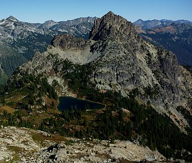
Peggys Pond and Cathedral Rock seen from Mt. Daniel.
-
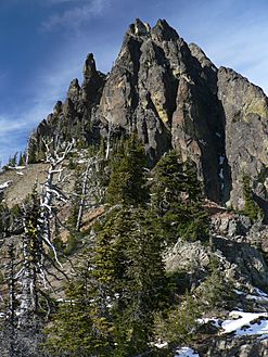
Cathedral Rock up close.
-
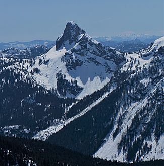
The north side of Cathedral Rock covered in snow.


