Caveside facts for kids
Quick facts for kids CavesideTasmania |
|||||||||||||||
|---|---|---|---|---|---|---|---|---|---|---|---|---|---|---|---|

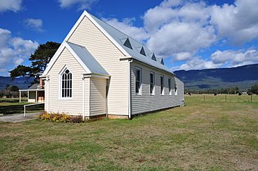
The "church in the paddock", Caveside's Church of Christ.
|
|||||||||||||||
| Population | 133 (2016 census) | ||||||||||||||
| Postcode(s) | 7304 | ||||||||||||||
| Location |
|
||||||||||||||
| LGA(s) | Meander Valley Council | ||||||||||||||
| Region | Launceston | ||||||||||||||
| State electorate(s) | Lyons | ||||||||||||||
| Federal Division(s) | Lyons | ||||||||||||||
|
|||||||||||||||
Caveside is a small rural area in Tasmania, Australia. It's found in the Meander Valley region. About 133 people lived here in 2016. Caveside is located about 45 kilometres (28 mi) (28 miles) southwest of Westbury. It sits between the Great Western Tiers mountains to the south and Mole Creek to the north.
Caveside is more of a farming community than a town. The area is known for its limestone rock. Over time, water has worn away this rock, creating many caves underground. To the west, you can find Wet Caves and Honeycomb Caves. These are popular spots for cavers, who explore caves. The land also has many sinkholes, which are dips in the ground. These can be a bit tricky for the cattle grazing in the fields. The name "Caveside" probably comes from these caves. Before 1897, it was called Brookside. This area used to be thick forest before people settled here. Farming, especially timber and dairy, has always been a big part of Caveside's history. In the early 1900s, it was famous for its excellent cattle and sheep.
Contents
Exploring Caveside's Past
Early Days and Churches
A person named Henry Reed was very important in Caveside's early history. He bought a large piece of land here in 1835. Reed even held some of the first church services in his home, which was called Wesley Dale. He gave land for a new church, hoping it would also be used as a school first. The first official church services began around 1875 in a private home. This home was in a field near the bridge over Lobster Creek.
The Caveside Wesleyan church and a small house were built and finished in 1876. In 1903, this church became the Caveside Methodist church. A new brick church replaced it in 1978, but it is no longer used for services.
Post Office and School Life
Caveside had a post office that opened on November 1, 1887. It operated from a private home and finally closed in 1980. A private school started in the Wesleyan church on June 4, 1877, with 27 students. A special one-room school building and a house for the teacher were built between 1892 and 1893. The school stayed in this building until it closed in 1937. The school building was later moved to Mole Creek in 1938. There, it was used for "domestic arts" (like cooking and sewing) at the Mole Creek district school.
Community Buildings and Fun
More buildings were added on the Methodist church's land. These included a small house and two buildings used as a shop and a post office. The shop and post office buildings were rented out from about 1900 to 1940. A community hall, known for its beautiful timber walls, was built in 1921.
A public swimming pool was built in 1957 by local volunteers. It was made bigger in 1980 with a tennis court. In 2001, gas barbeques were added. The pool is a 16-metre (52 ft) outdoor pool. The Caveside Recreation Committee manages it. The old shop is now closed, but the Caveside memorial hall is still open. The Meander Valley Council runs the hall.
The Church of Christ started a group in the area in 1909. Before that, services were held in Caveside. They built a church from hand-split timber and opened it in 1911. The original building was moved in 1956, and a new one was built. This building is now famously known as "The Church in the Paddock."
Caveside officially became a "locality" (a defined area) in 1965.
Caveside's Landscape
Lobster Rivulet, a small river that flows into the Mersey River, runs through Caveside. It flows from the south to the north.
Getting Around Caveside
The C169 route, also known as Caveside Road, enters the area from the northwest. It then runs through to the north, where it leaves. Another road, Route C168 (Western Creek Road), starts where it meets C169. It then goes southeast until it leaves the area.
 | Shirley Ann Jackson |
 | Garett Morgan |
 | J. Ernest Wilkins Jr. |
 | Elijah McCoy |


