Cedar Grove, Queensland facts for kids
Quick facts for kids Cedar GroveLogan City, Queensland |
|||||||||||||||
|---|---|---|---|---|---|---|---|---|---|---|---|---|---|---|---|

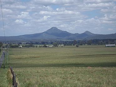
Flinders Peak from Cedar Grove, 2016
|
|||||||||||||||
| Population | 1,992 (2021 census) | ||||||||||||||
| • Density | 110.7/km2 (287/sq mi) | ||||||||||||||
| Postcode(s) | 4285 | ||||||||||||||
| Area | 18.0 km2 (6.9 sq mi) | ||||||||||||||
| Time zone | AEST (UTC+10:00) | ||||||||||||||
| Location |
|
||||||||||||||
| LGA(s) | Logan City | ||||||||||||||
| State electorate(s) | Scenic Rim | ||||||||||||||
| Federal Division(s) | Wright | ||||||||||||||
|
|||||||||||||||
Cedar Grove is a special kind of area called a locality in Queensland, Australia. It is part of Logan City. This area has a mix of different uses. In 2021, about 1,992 people lived in Cedar Grove.
Contents
Discovering Cedar Grove's Geography
Cedar Grove is bordered by the Logan River on its western side. Part of its northern edge also follows this river. You'll find the Cedar Grove Weir on the Logan River at the northern boundary. A weir is like a small dam that helps control water flow. The Mount Lindesay Highway runs along the eastern side of Cedar Grove.
The land in Cedar Grove is used for different things. The eastern and western parts are mostly for farming. Farmers here either raise animals like cattle (this is called grazing) or grow crops. In the middle of Cedar Grove, between the farming areas, you'll find homes where people live.
A Look Back at Cedar Grove's History
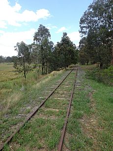
Cedar Grove has an interesting past. A railway line used to run through the area. This was the Beaudesert railway line, which connected Bethania to Beaudesert. It opened way back on May 16, 1888.
The Old Railway Station
The Cedar Grove railway station was built when the railway line was new. It was in an area then known as Cedar Pocket. An old map from 1888 even shows it as "Cedar Pocket South railway station." This station is no longer used today.
Schools in Cedar Grove's Past
Education has also been part of Cedar Grove's story. Around 1899, a school called Jimboomba Timber Reserve Provisional School opened. "Provisional" means it was a temporary school. In 1906, its name changed to Martindale Provisional School. Then, on January 1, 1909, it became Martindale State School. This school was located near Gittins Road. It closed in 1922.
The school building was then moved to Cedar Grove Road. It reopened there in 1923 as Cedar Grove State School. This school served the community until it closed in 1965.
Building the Cedar Grove Weir
The Cedar Grove Weir on the Logan River was built more recently. Construction started in March 2007 and finished in January 2008. This weir is important because it helps supply water to the South East Queensland Water Grid. This grid makes sure people in the region have enough water.
Changes in Local Government
Before March 2008, Cedar Grove was part of the Shire of Beaudesert. But then, local governments in Queensland changed. Cedar Grove became part of Logan City.
Cedar Grove's Population
The number of people living in Cedar Grove has changed a bit over the years.
- In 2011, there were 2,020 people.
- In 2016, the population was 2,041 people.
- In the most recent count in 2021, Cedar Grove had 1,992 residents.
Schools Near Cedar Grove
Cedar Grove itself does not have any schools. Students living here go to schools in nearby areas.
- For primary school, the closest government school is Woodhill State School. It's located in Woodhill, which is just south of Cedar Grove.
- For high school, students can attend Flagstone State Community College. This school is in Flagstone to the north. Another option is Beaudesert State High School, located in Beaudesert to the south.
 | Misty Copeland |
 | Raven Wilkinson |
 | Debra Austin |
 | Aesha Ash |


