
Jimboomba facts for kids
Quick facts for kids JimboombaLogan City, Queensland |
|||||||||||||||
|---|---|---|---|---|---|---|---|---|---|---|---|---|---|---|---|

The post office and veterinary surgery, Jimboomba
|
|||||||||||||||

Jimboomba
Location in Queensland
|
|||||||||||||||
| Population | 7,423 (2021 census) | ||||||||||||||
| • Density | 136.96/km2 (354.7/sq mi) | ||||||||||||||
| Established | 1845 | ||||||||||||||
| Postcode(s) | 4280 | ||||||||||||||
| Area | 54.2 km2 (20.9 sq mi) | ||||||||||||||
| Time zone | AEST (UTC+10:00) | ||||||||||||||
| Location |
|
||||||||||||||
| LGA(s) | Logan City | ||||||||||||||
| State electorate(s) | Logan | ||||||||||||||
| Federal Division(s) | Wright | ||||||||||||||
|
|||||||||||||||
Jimboomba is a town and area in Queensland, Australia. It is part of the City of Logan. In 2021, about 7,423 people lived in Jimboomba.
Contents
- Where is Jimboomba Located?
- What is Jimboomba's History?
- Who Lives in Jimboomba?
- What Does Jimboomba's Economy Look Like?
- Where Can Students Go to School in Jimboomba?
- What Services Does Jimboomba Offer?
- What is the Greater Flagstone Development?
- What Sports and Activities Can You Do in Jimboomba?
- Images for kids
Where is Jimboomba Located?
Jimboomba is found on the Mount Lindesay Highway. It is about 29.6 kilometers (18.4 miles) south-east of Logan Central. It is also about 48.7 kilometers (30.3 miles) south of Brisbane's city center.
The Logan River forms the western edge of Jimboomba. Payne Bridge on Cusack Lane is the only bridge for cars in the area. There is an older bridge nearby, but cars cannot use it.
The Queensland Government plans for Jimboomba to grow a lot. It will become a major living and business area. This is part of the Greater Flagstone plan. This plan aims to add up to 150,000 new residents in the future. Even though it used to be a farming area, most of Jimboomba is now homes.
What is Jimboomba's History?
The name Jimboomba comes from the original spelling, Gimboomba. This was the name of a large sheep and livestock farm. The farm covered the area where the town is today.
Gimboomba is a word from the Gugingin people. They are the traditional owners of this land. The word means "place of loud thunder and little rain." A special culture trail at a local school celebrates this history. It is called 'Loud Thunder' to honor the First Australian peoples.
The land was first used for grazing sheep in 1845. Later, it became a place for cattle.
Jimboomba's Railway History
Jimboomba once had a railway station. It was on the old Beaudesert railway line. This line connected Bethania to Beaudesert. It opened in 1888. The railway line closed in 1995.
Later, railway fans reopened part of the line for tourist rides. This lasted from 1999 until 2004. But it was hard to raise money, so the line closed for good.
Schools in Jimboomba's Past
Jimboomba Timber Reserve Provisional School opened around 1899. It changed its name to Martindale Provisional School in 1906. Then, in 1909, it became Martindale State School. This school closed in 1922. The school building was then moved and reopened as Cedar Grove State School. That school closed in 1965.
Jimboomba Provisional School opened on May 12, 1890. It became Jimboomba State School in 1900.
Emmaus Primary School started in 2002. It was a special school for different Christian groups. In 2005, it became Emmaus College. This was to prepare for adding high school grades in 2006.
A Japanese international school, South Queensland Academy (SQA), opened in Jimboomba in 1992. It closed in 2006. Hills International College now uses that location.
In 2008, Jimboomba became part of Logan City. Before that, it was in the Shire of Beaudesert.
In 2017, some parts of Jimboomba were separated. These areas became new places called Glenlogan and Riverbend. This also allowed Flagstone and South Maclean to grow.
Who Lives in Jimboomba?
In 2016, Jimboomba had 13,201 people. About half were female and half were male. The average age was 34 years old. This is younger than the national average of 38.
Most people (78.75%) living in Jimboomba were born in Australia. Other countries of birth included New Zealand (5.2%) and England (4.8%). Most people (91%) spoke only English at home.
In 2021, Jimboomba's population was 7,423 people. This number was lower than in 2016. This is because some land was separated from Jimboomba in 2017.
What Does Jimboomba's Economy Look Like?
In the past, Jimboomba was known for cutting timber and raising sheep and cattle. Today, Jimboomba has a growing industrial area. This area provides many services. These include vehicle repairs, irrigation supplies, and home water services. There are also places for farm produce, light manufacturing, and landscape gardening.
Where Can Students Go to School in Jimboomba?
Jimboomba has several schools for students.
- Jimboomba State School is a government primary school. It teaches students from Prep (kindergarten) to Year 6. In 2018, it had 837 students. It also has a special education program.
- Emmaus College is a school for both primary and secondary students. It teaches from Prep to Year 12. In 2018, 1,379 students attended this school.
- Hills International College is a private school. It teaches students from Prep to Year 12. In 2018, it had 487 students.
There is no government high school right in Jimboomba. Students can go to Flagstone State Community College in Flagstone. Another option is Park Ridge State High School in Park Ridge.
What Services Does Jimboomba Offer?
Jimboomba has many important services for its residents. These include:
- A Fire and Rescue station (with volunteer firefighters).
- A permanent ambulance service.
- A police station.
- A State Emergency Services (SES) depot.
- Shops for daily needs.
- A hotel.
- Medical and dental services.
The Logan City Council also runs a public library in Jimboomba.
What is the Greater Flagstone Development?
The suburb of Flagstone is growing very fast. It started on one side of the railway line. Now, it is expanding to the west. A new town center is planned there.
More homes are being built in nearby areas like Undullah and South Maclean. This big project is called the Greater Flagstone development area. It covers a huge area of about 7,188 hectares (17,762 acres). The final plan for this project was approved in 2011.
What Sports and Activities Can You Do in Jimboomba?
Jimboomba has several well-known sports teams.
- The Jimboomba Thunder is a rugby league club. They play their home games at Jimboomba Park.
- The Jimboomba Redbacks is an AFL club. They play at Glenlogan Park.
- Glenlogan Park is also home to the Jimboomba Cricket Club.
Many people in Jimboomba own horses. They enjoy riding them for fun or in competitions.
Jimboomba also has the Jimboomba X Stadium. This is an outdoor place for extreme sports. It has hosted big events like the Queensland Supercross Championship. It also held rounds of the Australian Supercross Championship.
Images for kids
-
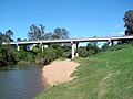
Payne Bridge over the Logan River, 2011
-
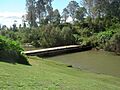
Old low-level bridge across the Logan River, 2011


