Charleston, Vermont facts for kids
Quick facts for kids
Charleston, Vermont
|
|
|---|---|
|
Town
|
|

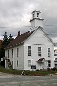
The Plymouth Congregational Church on VT Rte 105 in East Charleston
|
|

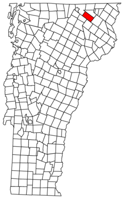
Located in Orleans County, Vermont
|
|

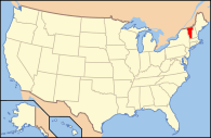
Location of Vermont with the U.S.A.
|
|
| Country | United States |
| State | Vermont |
| County | Orleans |
| Chartered | November 10, 1780 |
| Communities |
|
| Area | |
| • Total | 38.6 sq mi (100.0 km2) |
| • Land | 37.5 sq mi (97.1 km2) |
| • Water | 1.1 sq mi (2.9 km2) |
| Elevation | 1,196 ft (358 m) |
| Population
(2020)
|
|
| • Total | 1,021 |
| • Density | 27/sq mi (10.5/km2) |
| • Households | 362 |
| • Families | 26,123.9 |
| Time zone | UTC-5 (EST) |
| • Summer (DST) | UTC-4 (EDT) |
| ZIP Codes | |
| Area code(s) | 802 |
| FIPS code | 50-13150 |
| GNIS feature ID | 1462067 |
Charleston is a small town located in Orleans County, Vermont, in the United States. In 2020, about 1,021 people lived there. The town includes two smaller communities: East Charleston and West Charleston.
Contents
History of Charleston, Vermont
Early Days and Name Change
Long ago, the Native Abenakis people told stories about a large pond that "ran away." This happened in the 1780s, before people from Europe explored the area.
A naval officer named Commodore Abraham Whipple was given the land for the town. He shared it with about 50-60 of his shipmates. He first named the town "Navy." The very first settler, Abner Allen, arrived in 1803 from Barton, Vermont.
In 1825, the town of Navy changed its name to Charleston. People believe it was named after an important naval battle that took place near Charleston, South Carolina.
Charleston During the Civil War
During the American Civil War, Charleston sent 121 men to fight. Sadly, 35 of these soldiers died. They were either killed in battle or passed away from injuries or sickness they got while serving.
Growth and Challenges
In the late 1800s and early 1900s, Charleston had many mills. These mills helped the town grow, and its population reached a high of 1,700 people.
In 1908, a special round barn was built in Charleston. It might have been the biggest round barn in all of New England! Unfortunately, this large barn burned down in 1918. You can still see its big stone foundation along the Ten Mile Square Road.
The town faced more challenges when a series of fires destroyed parts of it. East Charleston burned on May 18, 1921, and West Charleston caught fire the very next day.
Geography of Charleston
Land and Water
Charleston covers about 38.6 square miles (100.0 square kilometers) in total. Most of this area, about 37.5 square miles (97.1 square kilometers), is land. The rest, about 1.1 square miles (2.9 square kilometers), is water.
Rivers and Lakes
The Clyde River is the biggest stream in Charleston. It flows through the middle of the town from north to west. The river has some waterfalls, especially in the western part of town. Here, the water drops over 100 feet (30 meters) in a short distance. However, the river's flow is usually slow.
Echo Lake is in the eastern part of town. Water from Lake Seymour and Holland Pond flows into Echo Lake. Echo Lake is about one mile (1.6 km) from East Charleston. It is about 1.5 miles (2.4 km) long and one mile (1.6 km) wide. An early explorer, General Whitelaw, named it Echo Pond. He noticed that any sound made near the lake would bounce around, creating many echoes!
Pensioners Pond is the next largest lake. It got its name because a soldier from the American Revolution used its water power.
Above Pensioners Pond is Toad Pond, which is near a large swamp. Broadway Pond is another pond, located near the Morgan town line.
Population of Charleston
How Many People Live Here?
| Historical population | |||
|---|---|---|---|
| Census | Pop. | %± | |
| 1810 | 56 | — | |
| 1820 | 90 | 60.7% | |
| 1830 | 564 | 526.7% | |
| 1840 | 731 | 29.6% | |
| 1850 | 1,008 | 37.9% | |
| 1860 | 1,160 | 15.1% | |
| 1870 | 1,278 | 10.2% | |
| 1880 | 1,204 | −5.8% | |
| 1890 | 1,058 | −12.1% | |
| 1900 | 1,025 | −3.1% | |
| 1910 | 993 | −3.1% | |
| 1920 | 921 | −7.3% | |
| 1930 | 895 | −2.8% | |
| 1940 | 834 | −6.8% | |
| 1950 | 764 | −8.4% | |
| 1960 | 668 | −12.6% | |
| 1970 | 654 | −2.1% | |
| 1980 | 851 | 30.1% | |
| 1990 | 844 | −0.8% | |
| 2000 | 895 | 6.0% | |
| 2010 | 1,023 | 14.3% | |
| 2020 | 1,021 | −0.2% | |
| U.S. Decennial Census | |||
In the year 2000, there were 895 people living in Charleston. These people lived in 362 households, with 261 of them being families. The town had about 24 people per square mile (9.2 per square kilometer).
About 24.4% of the people were under 18 years old. Around 11.7% were 65 years old or older. The average age of people in Charleston was 41 years.
Notable People from Charleston
- Benjamin Hunkins: He was a pioneer and a lawmaker in Wisconsin. He was born in Charleston.
- Robert Mills: A famous physicist who studied tiny particles. He passed away in East Charleston, Vermont in 1999.
See also
 In Spanish: Charleston (Vermont) para niños
 | George Robert Carruthers |
 | Patricia Bath |
 | Jan Ernst Matzeliger |
 | Alexander Miles |

