
Chester Heights, Pennsylvania facts for kids
Quick facts for kids
Chester Heights, Pennsylvania
|
|
|---|---|

|
|

Location in Delaware County and the U.S. state of Pennsylvania.
|
|

Chester Heights, Pennsylvania
Location in Pennsylvania

Chester Heights, Pennsylvania
Location in the United States
|
|
| Country | United States |
| State | Pennsylvania |
| County | Delaware |
| Incorporated | 1945 |
| Area | |
| • Total | 2.22 sq mi (5.74 km2) |
| • Land | 2.21 sq mi (5.73 km2) |
| • Water | 0.00 sq mi (0.01 km2) |
| Elevation | 131 ft (40 m) |
| Population
(2020)
|
|
| • Total | 2,897 |
| • Density | 1,308.49/sq mi (505.29/km2) |
| Time zone | UTC-5 (EST) |
| • Summer (DST) | UTC-4 (EDT) |
| ZIP code |
19017
|
| Area code(s) | 610 and 484 |
| FIPS code | 42-13232 |
Chester Heights is a small town, called a borough, in Pennsylvania, USA. It's located in Delaware County. In 2010, about 2,531 people lived here. By 2020, the population grew to 2,897. Most of the borough is south of a big road called U.S. Route 1, not far from the Wawa area.
Contents
Exploring the History of Chester Heights
The story of Chester Heights began even before William Penn received his land grants. Long ago, Swedes explored this area from the Delaware River. They found the soil was very good for farming. For a long time, the land was used for farms.
Early Days and the Railroad
In the 1700s and 1800s, Chester Heights was part of Aston Township. However, it didn't have a main village area. Things started to change when a railroad came through. The first train ran on Christmas Day in 1833. After that, more houses began to appear near the railroad.
As cars became popular, more homes were built along the oldest road in the borough. This road is now called Valleybrook Road. It used to be known as "Logtown Road." It was one of the first paths from the Chester settlement to the inland areas. This road winds along the West Branch of Chester Creek and has some sharp turns.
Schools and Local Names
An old school building from 1836 stood on Valleybrook Road. Aston Township rented it for just $2 a month to use as a school. It was first called the Logtown School. In 1880, its name changed to the Chester Heights School. Today, a newer stone school building stands in its place.
Chester Heights was once the Fourth Ward of Aston. For a while, people called it "Chester Heights and Wawa." The northern part, known as "Wawa," was where many large properties were bought for summer homes. These areas are still mostly unchanged today. They are now used as homes all year round. The name "Wawa" comes from an old Native American word for "wild goose."
Important Buildings and Incorporation
In 1852, the first stone was laid for St. Thomas the Apostle Church. This church was built for a Roman Catholic group that had been meeting since 1728. Today, it includes a modern church, a school, and homes.
In 1872, a group of Methodists bought a farm in Aston. They formed the Chester Heights Camp-Meeting Association. They still meet every July for religious retreats. Chester Heights officially became its own borough in 1945.
Historic Homes and Landmarks
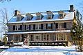
Today, about a dozen old homes made of fieldstone or brick are still standing. Some of the oldest houses date back to 1720 or even earlier. Many were already built by 1777. At that time, soldiers from the Battle of Brandywine rested in the area. They slept in barns and open fields. These homes show a valuable history of architecture from the 1700s to the Victorian era.
Several places in Chester Heights are listed on the National Register of Historic Places. These include the Chester Heights Camp Meeting Historic District, the Chamberlain-Pennell House, and Stonehaven.
Chester Heights was also the setting for the fictional Grogan family in the 2008 movie "Marley and Me."
Where is Chester Heights Located?
Chester Heights is in the western part of Delaware County. It is located at coordinates 39.889539 degrees North and -75.470931 degrees West.
It shares borders with several other townships. To the southeast is Aston Township. To the west is Concord Township. Thornbury Township is to the north. Across Chester Creek to the northeast is Middletown Township.
The United States Census Bureau says the borough covers about 5.7 square kilometers (2.2 square miles). Almost all of this area is land.
What is the Climate Like?
Chester Heights has hot, humid summers. Winters are generally cool to cold. This type of weather is called a hot-summer humid continental climate. It is shown as "Dfa" on climate maps. The local plant hardiness zone is 7a.
On June 23, 2015, a very strong thunderstorm hit the borough. It caused a lot of wind damage. Many trees fell, and power poles broke. Nearby areas were later declared disaster zones. At the Philadelphia International Airport, winds reached 71 miles per hour during the storm.
| Climate data for Chester Heights, Pennsylvania | |||||||||||||
|---|---|---|---|---|---|---|---|---|---|---|---|---|---|
| Month | Jan | Feb | Mar | Apr | May | Jun | Jul | Aug | Sep | Oct | Nov | Dec | Year |
| Mean daily maximum °C (°F) | 5 (41) |
6 (43) |
11 (52) |
18 (64) |
23 (74) |
29 (84) |
31 (88) |
30 (86) |
26 (79) |
19 (67) |
13 (55) |
7 (45) |
18 (65) |
| Daily mean °C (°F) | 1 (34) |
2 (36) |
7 (44) |
13 (55) |
18 (65) |
23 (74) |
26 (79) |
25 (77) |
21 (70) |
15 (59) |
9 (48) |
3 (38) |
13 (56) |
| Mean daily minimum °C (°F) | −2 (28) |
−2 (29) |
2 (36) |
7 (45) |
13 (55) |
18 (65) |
21 (70) |
20 (68) |
16 (61) |
10 (50) |
5 (41) |
−1 (31) |
9 (48) |
| Average precipitation cm (inches) | 7.6 (3) |
6.6 (2.6) |
9.4 (3.7) |
8.6 (3.4) |
9.1 (3.6) |
8.9 (3.5) |
11 (4.3) |
9.9 (3.9) |
9.7 (3.8) |
7.4 (2.9) |
8.4 (3.3) |
8.1 (3.2) |
105 (41.3) |
| Source: Weatherbase | |||||||||||||
How Do People Get Around?
_just_north_of_Valleybrook_Road_and_Walnut_Hill_Boulevard_in_Chester_Heights,_Delaware_County,_Pennsylvania.jpg)
As of 2008, Chester Heights had about 10.42 miles of public roads. The Pennsylvania Department of Transportation (PennDOT) took care of 7.90 miles. The borough itself maintained the remaining 2.52 miles.
U.S. Route 1 is the main highway in Chester Heights. It runs from southwest to northeast through the northwestern part of the borough. US 1 goes northeast about 20 miles to Philadelphia. It goes southwest about 13 miles to Kennett Square. You can also reach Chester about 7 miles to the southeast.
Who Lives in Chester Heights?
| Historical population | |||
|---|---|---|---|
| Census | Pop. | %± | |
| 1950 | 474 | — | |
| 1960 | 534 | 12.7% | |
| 1970 | 597 | 11.8% | |
| 1980 | 1,302 | 118.1% | |
| 1990 | 2,273 | 74.6% | |
| 2000 | 2,481 | 9.2% | |
| 2010 | 2,531 | 2.0% | |
| 2020 | 2,897 | 14.5% | |
In 2010, most people in Chester Heights were White (92.1%). About 3.3% were African American, and 3.2% were Asian. A small number were from other races or mixed races. About 1.5% of the population was Hispanic or Latino.
In 2000, there were 2,481 people living in the borough. There were 1,056 households, and 664 families. The population density was about 1,184.8 people per square mile.
About 29.3% of households had children under 18. Almost half (49.7%) were married couples. About 9.8% had a female head of household with no husband. The average household had 2.32 people, and the average family had 2.93 people.
The population was spread out by age. About 23.1% were under 18. About 35.2% were between 25 and 44. The median age was 37 years old.
The average income for a household in 2000 was $70,236. For families, it was $74,375. The average income per person was $37,707. A small number of families (2.6%) and people (4.3%) lived below the poverty line.
What is the Economy Like?

The company Wawa Food Markets has its main office in Chester Heights. This office is located in the Wawa area. In 2011, about 300 people worked at the headquarters. The borough of Chester Heights gets most of its local service tax money from Wawa employees.
Learning and Education
The Rachel Kohl Library serves the community of Chester Heights.
Students in Chester Heights attend schools in the Garnet Valley School District. Younger students go to Concord Elementary School (grades K-2) or Garnet Valley Elementary School (grades K-5). Middle school students attend Garnet Valley Middle School (grades 6-8). High school students go to Garnet Valley High School (grades 9-12).
Chester Heights Fire Company
The Chester Heights Fire Company started in 1947. It is known as Station 71 on the Delaware County fire radio. The fire station is located at the corner of Valleybrook Road and Llewellyn Road.
The fire company has several vehicles. These include an engine (Engine 71), a rescue truck (Rescue 71), a Quick Response Service (QRS) vehicle (QRS 71), and a utility pickup truck (Utility 71). The fire company is made up entirely of volunteers. They serve Chester Heights and parts of Thornbury Township. They also help other nearby townships when needed. In May 2015, the company finished building a new station. Today, there are about 20 volunteer members.
Images for kids
-
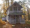
Chester Heights Camp Meeting Historic District
-
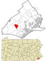
Location in Delaware County and the U.S. state of Pennsylvania.
-
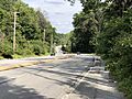
US 1 northbound in Chester Heights
-
A building of the Wawa Food Markets headquarters
See also
 In Spanish: Chester Heights para niños
