Chetamon Mountain facts for kids
Quick facts for kids Chetamon Mountain |
|
|---|---|

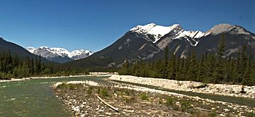
Chetamon Mountain and Snaring River seen from Highway 16
|
|
| Highest point | |
| Elevation | 2,606 m (8,550 ft) |
| Prominence | 122 m (400 ft) |
| Listing | Mountains of Alberta |
| Geography | |
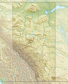
| Location | Jasper National Park Alberta, Canada |
| Parent range | De Smet Range Canadian Rockies |
| Topo map | NTS 83E/01 |
| Type of rock | sedimentary rock |
Chetamon Mountain is a mountain in Jasper National Park, Alberta, Canada. It stands 2,606-metre (8,550-foot) tall in the Canadian Rockies. This mountain is part of the De Smet Range.
You can see Chetamon Mountain from Highway 16. It is also visible from "The Canadian" train. The mountain is about 18 kilometres (11 mi) north of the town of Jasper. Its closest taller neighbor is Cliff Mountain, which is 3.5 km (2.2 mi) to the northwest.
What Does Chetamon Mean?
The name Chetamon Mountain comes from the Stoney language. In this language, "Chetamon" means "squirrel". The mountain got its name in 1916 from Morrison P. Bridgland. He was a Dominion Land Surveyor, which means he helped map out land for the Canadian government.
Bridgland named the mountain because two rocks on its ridge looked like a squirrel. He named many other peaks in Jasper Park and the Canadian Rockies. The name Chetamon Mountain became official in 1956.
Mountain Weather
Chetamon Mountain has a subarctic climate. This means it has very cold and snowy winters. Temperatures can drop below -20 °C (that's -4 °F!). With the wind chill, it can feel even colder, sometimes below -30 °C (-22 °F).
Summers on the mountain are mild. The best time to visit or climb Chetamon Mountain is from June to September. Water from the mountain flows into the Athabasca River. This happens through the Snaring River and Cobblestone Creek.


