
Chiapas Depression dry forests facts for kids
Quick facts for kids Chiapas Depression dry forests |
|
|---|---|

Chiapas Depression dry forests in Sumidero Canyon
|
|

Ecoregion territory (in purple)
|
|
| Ecology | |
| Realm | Neotropical |
| Biome | tropical and subtropical dry broadleaf forests |
| Borders | Central American pine–oak forests, Chimalapas montane forests, Petén–Veracruz moist forests, and Sierra Madre de Chiapas moist forests |
| Geography | |
| Area | 13,974 km2 (5,395 sq mi) |
| Countries | southern Mexico and Guatemala |
| Conservation | |
| Conservation status | Critical/Endangered |
| Global 200 | Mexican dry forests |
| Protected | 309 km² (2%) |
The Chiapas Depression dry forests are a special type of forest found in northwestern Central America. They are called 'dry forests' because they have a long dry season each year. These forests are part of a larger group of ecosystems known as tropical and subtropical dry broadleaf forests. The World Wildlife Fund helps to define and protect these important natural areas.
Contents
Where Are These Forests?
These forests are located in a valley called the Chiapas Depression. This valley is mostly in Chiapas state, Mexico. It also reaches into northwestern Guatemala. Big mountains surround this valley. To the north are the Chiapas Highlands. To the south is the Sierra Madre de Chiapas. The Grijalva River flows through this area.
The Chiapas Depression dry forests cover about 13,900 square kilometers (5,367 square miles). They sit at an elevation of about 420 to 800 meters (1,378 to 2,625 feet) above sea level.
What is the Climate Like?
The climate in the Chiapas Depression dry forests is hot and dry for part of the year. This area is in a "rain shadow." This means the mountains block much of the rain from reaching the valley. So, it is drier here than in the surrounding highlands.
Most of the rain falls during the summer months. There is a long dry season that lasts for four to six months. In the driest parts, the area can get less than 800 mm (31 inches) of rain each year.
What Plants Grow Here?
The main type of plant life here is the tropical deciduous dry forest. Many trees in these forests lose their leaves during the long dry season. This makes the forest look very different between the wet and dry times of the year.
The trees are usually not very tall. Some common trees include Lysiloma divaricatum, Mexican alvaradoa (Alvaradoa amorphoides), and peacock flower (Caesalpinia pulcherrima). You can also find ceiba or kapok (Ceiba pentandra) and buttercup tree (Cochlospermum vitifolium). Cactus and other plants that store water are also common.
In canyons and areas with more moisture, you might find taller forests. These forests have trees that lose some or all of their leaves. Along rivers, you can see Montezuma cypress (Taxodium mucronatum) and fig trees (Ficus species).
Some parts of the ecoregion have savannas, which are grasslands with scattered trees. Areas changed by people or farm animals often have grasslands and palm groves.
This ecoregion has many different kinds of plants, which is called high biodiversity. There are about 980 plant species here. About 40% of the plants found only in dry areas of Mexico live here. This area also connects two important natural regions: the Gulf of Mexico and the Pacific.
What Animals Live Here?
Many interesting animals call these dry forests home.
Mammals
Some native mammals you might find include the gray fox (Urocyon cinereoargenteus). You can also see the hooded skunk (Mephitis macroura) and the hog-nosed skunk (Conepatus mesoleucos). These animals are often found in isolated mountains and canyons where there is less human activity.
Birds
Characteristic birds of this region include the plain chachalaca (Ortalis vetula). Other birds are the mottled owl (Strix virgata), the lesser roadrunner (Geococcyx velox), and the white-throated magpie-jay (Calocitta formosa).
Reptiles
Native snakes found here include the boa constrictor (Boa constrictor). Another snake is the neotropical rattlesnake (Crotalus durissus).
-
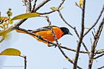
Icterus galbula in Tuxtla Gutiérrez, Mexico
-
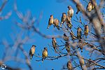
Bombycilla cedrorum in Chiapa de Corzo, Mexico


Protecting the Forests
The Chiapas Depression dry forests are facing serious threats. One of the biggest problems is cattle grazing. This means large areas of forest are cleared for cows to eat grass. Logging (cutting down trees) and expanding farms also cause a lot of damage.
Much of the ecoregion has been turned into farmland. People grow crops like corn, beans, and peanuts here. Sugarcane and corn are also grown in areas where they can be watered. Large parts have been cleared to create pastures for cattle.
Tuxtla Gutiérrez is the largest city in this ecoregion.
Protected Areas
In 2017, it was found that about 2% of the ecoregion is protected. This is about 309 square kilometers (119 square miles). Some of the protected areas include Sumidero Canyon National Park. A part of La Sepultura Biosphere Reserve is also within this ecoregion. These protected areas help to save the plants and animals that live there.
See also
 In Spanish: Bosques secos de la depresión de Chiapas para niños
- List of ecoregions in Mexico
- Tropical and subtropical dry broadleaf forests ecoregions
