Chipps Island facts for kids

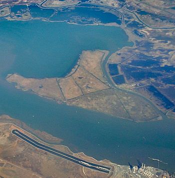
Chipps Island from the south, in an aerial photo from 2015
|
|
| Geography | |
|---|---|
| Location | Northern California |
| Coordinates | 38°03′19″N 121°54′43″W / 38.05528°N 121.91194°W |
| Adjacent bodies of water | Suisun Bay |
| Administration | |
| State | |
| County | Solano |
Chipps Island is a small island located in Suisun Bay, California. It is part of Solano County. This island has an interesting history, including being considered for a large dam project.

Discovering Chipps Island
Chipps Island is also known by another name: Knox Island. This name appeared on old maps from the 1850s. One map was made by Cadwalader Ringgold in 1850. Another was made by Henry Lange in 1854.
In 1959, the state of California used Chipps Island. It helped define the western border of the Sacramento–San Joaquin River Delta. This shows how important the island was for mapping the area.
Big Plans for a Dam
In the 1960s, there were big plans for water projects in California. One idea was to build a huge dam near Chipps Island. This dam would have been built across the Carquinez Strait. It was meant to create a large freshwater lake. This would stop fresh water from flowing into the Pacific Ocean.
The dam project was estimated to cost a lot of money. It was expected to hold a huge amount of fresh water. However, this project faced big problems. Experts worried about how it would affect wildlife. They were especially concerned about salmon. The dam might have stopped salmon from swimming upstream to lay their eggs.
Because of these serious concerns, the dam project was eventually stopped. By 1964, new plans for managing freshwater in the region did not include the Chipps Island dam.
Land and Resources
Chipps Island is located near areas with natural gas and oil. In 1967, companies were invited to bid for rights to drill for oil and gas near the island.
In the 2010s, Chipps Island was part of a large land purchase. The Metropolitan Water District of Southern California tried to buy it. They also wanted to buy other nearby islands and land areas. These included Bouldin and Bacon Islands. They also wanted parts of the Holland and Webb Tracts.
However, this land purchase led to a lawsuit. Several environmental groups and water agencies sued the district. The counties of Contra Costa and San Joaquin also joined the lawsuit.
 | Victor J. Glover |
 | Yvonne Cagle |
 | Jeanette Epps |
 | Bernard A. Harris Jr. |


