Christian Island facts for kids
|
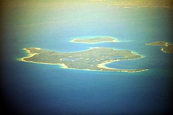
Aerial view of Christian Island from the southeast.
|
|
| Geography | |
|---|---|
| Location | Georgian Bay, Lake Huron |
| Highest elevation | 209 m (686 ft) |
Christian Island is a large island located in Georgian Bay, a part of Lake Huron. It's close to the towns of Penetanguishene and Midland in Ontario, Canada.
This island, along with its neighbours Hope Island and Beckwith Island, forms a large Ojibwe reserve. This reserve is known as Christian Island Indian Reserve No. 30. The total land area of these islands is about 5,428 hectares (13,413 acres).
There are also two smaller reserves connected to Christian Island. One is Christian Island Indian Reserve No. 30A, located at Cedar Point, Ontario. The other is Chippewa Island Indian Reserve, found in Twelve Mile Sound. Together, these reserves make up the land base for the Beausoleil First Nation. Christian Island's highest point is 209 metres (686 feet) above sea level.
To the east of Christian Island, you'll find Giants Tomb Island and Beausoleil Island. Beausoleil Island is part of the Georgian Bay Islands National Park. It's also part of UNESCO's Georgian Bay Biosphere Reserve (GBBR). This reserve covers a huge area of 347,000 hectares (857,450 acres). It stretches 200 kilometres (124 miles) along Georgian Bay's eastern coast. This area is known as The Thirty Thousand Islands, the world's largest freshwater archipelago.
The Beausoleil First Nation, along with other First Nations in the area, has a land claim. This claim is for lands between Matchedash Bay and the narrows at Lake Simcoe and Lake Couchiching. While the Chippewa Island reserve is shared, the two Christian Island reserves belong only to the Beausoleil First Nation.
Contents
Discovering Christian Island's Past
Christian Island is mostly covered by forests. The ground is made of limestone rock and sandy soil. This sand is left over from a huge ancient lake called Glacial Lake Algonquin.
You can even find a special type of grass here called Forked three-awned grass. Some people call it "Ice Age Grass" because it's linked to the island's icy beginnings. This grass is very rare and is considered a species at risk.
How Christian Island Got Its Name
Long ago, Christian Island was known by its Huron name, Gahoendoe. In the 1800s, the three main islands were called the Christian Islands. Beckwith Island was known as Faith Island, and Christian Island, being the largest, was called Charity Island.
In 1649, during the Huron-Iroquois wars, thousands of Huron people and some Jesuit missionaries sought safety on the island. They had come from Sainte-Marie among the Hurons. The Jesuits named the island St. Joseph Island. Sadly, many people didn't have enough food and starved during that winter. The island became known as "Christian" Island because Huron Catholics and Jesuits stayed there. It was named in honour of the Canadian Martyrs.
The Jesuits and most of the Huron people left the island in the summer of 1650. The remaining Huron and Petun people left in 1651. Their descendants later settled near Detroit and Windsor. Some were later moved to Oklahoma.
The Beausoleil First Nation's Home
Today, Christian Island is home to the Beausoleil First Nation. Their ancestors used to travel a lot, moving around northern Georgian Bay and the Great Lakes. The Canadian government encouraged them to settle down. They lived at Coldwater from 1834 to 1842. Later, they moved to Beausoleil Island in 1842. Finally, in 1856, they settled on Christian Island, where they have lived ever since.
The First Nation has tried different ways to earn money on the reserve. They've had pheasant hunting, a cattle farm, and a charcoal business. They also ran a commercial fishing operation. Today, some land is rented out for cottages. Many residents now work on the mainland. A growing community has also developed at Cedar Point, where the ferry lands. Hope and Beckwith islands are not lived on, but boaters often visit them. Boaters pay a small fee to the First Nation community.
The Beausoleil First Nation provides important services for its community. They operate an elementary school, a health centre, and a community centre. There is also 24-hour emergency medical service (EMS) and a volunteer fire department.
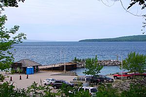
A ferry service connects Christian Island to the mainland at Cedar Point. The Sandy Graham is a car ferry that travels regularly between the island and the mainland. Another ferry, the Indian Maiden, carries only passengers. It can break through ice up to 6 inches thick. A hovercraft is available for emergencies. When it's very cold, people sometimes build an ice road across the water. This ice road was open in February 2014 due to thick ice.
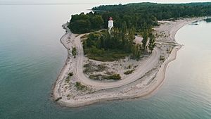
Christian Island has a lighthouse at its southern tip. This lighthouse helped guide ships traveling from Collingwood to Penetanguishene, Midland, and Parry Sound. It was first lit in 1859. It is one of the oldest lighthouses in Georgian Bay and one of the six famous Imperial Towers.
Important People from Christian Island
Rodney Monague (1942–2013) was a very important leader for Christian Island. He became the island's first chief after government agents left in the 1960s. He served as chief for over twenty years, from the late 1960s until about 1990.
The famous Canadian folk singer Gordon Lightfoot wrote a song about Christian Island in 1972. The song is called "Christian Island (Georgian Bay)." It mentions the island's popularity for sailing.
Exploring Shipwrecks Near Christian Island
Christian Island is a popular spot for scuba diving because of the many old shipwrecks nearby. Most of these ships sank a century or more ago. They are found close to Christian Island and the uninhabited Hope Island. Some of these shipwrecks include:
- Mapledawn: A steel freighter built in 1890 that sank in 1924. It's located northwest of Christian Island.
- Saucy Jim: This ship sank in 1910 and is east of Christian Island.
- Michigan: A grain vessel that sank in 1843, found northwest of Hope Island.
- Lottie Wolf: A schooner that sank in 1879, located northeast of Hope Island.
- Marquette: This ship sank in 1867 and is east of Hope Island.
Lake Huron, where Georgian Bay is located, is home to hundreds of other sunken ships. Many of them are very old and important to history. These shipwrecks are usually well-preserved because the water is cold and fresh.
How Christian Island is Governed
The Beausoleil First Nation holds general elections every two years. This is done according to the Indian Act election rules.
In the June 23, 2018 election, the following leaders were chosen:
- Chief: Guy Monague
- Chief Councillor: Joanne Sandy
- Councillor: Kristin Monague
- Councillor: Lauraine Judith Jamieson
- Councillor: Hank Monague
- Councillor: Angela Beedie
- Councillor: C. Susan Copegog
The new Chief and Council officially started their roles on July 6, 2018.
Since November 2016, Terra Sandy Roy has served as the Youth Chief, with Lance Copegog as the Deputy Youth Chief.
The Oath of Office for the June 2021 election took place on June 1, 2021.
 | William M. Jackson |
 | Juan E. Gilbert |
 | Neil deGrasse Tyson |


