
Cloudy Peak (North Cascades) facts for kids
Quick facts for kids Cloudy Peak |
|
|---|---|

Cloudy Peak seen from Suiattle Pass
|
|
| Highest point | |
| Elevation | 7,915 ft (2,412 m) |
| Prominence | 195 ft (59 m) |
| Parent peak | North Star Mountain 8,096 ft |
| Geography | |

Cloudy Peak
Location in Washington (state)

Cloudy Peak
Location in the United States
|
|
| Parent range | North Cascades Cascade Range |
| Topo map | USGS Suiattle Pass |
| Geology | |
| Age of rock | Cretaceous |
| Climbing | |
| First ascent | 1921, party of The Mountaineers |
| Easiest route | Scrambling |
Cloudy Peak is a tall mountain in Washington state. It stands about 7,915 feet (2,412 meters) high. This peak is found in the Glacier Peak Wilderness area. It is part of the beautiful North Cascades mountain range.
Cloudy Peak is located in Chelan County. The closest taller mountain is North Star Mountain. It is only about 0.67 miles (1.08 km) away. Water from Cloudy Peak flows into Agnes Creek and Railroad Creek. These creeks then join the Chelan River. The first people to climb Cloudy Peak were from The Mountaineers club in 1921.
Contents
How Cloudy Peak Was Formed
Cloudy Peak is part of a large rock formation called the Cloudy Pass batholith. A batholith is a huge mass of igneous rock that formed deep underground. This particular batholith was created about 20 million years ago. This happened during a time called the early Miocene Epoch.
The Story of the Cascade Mountains
The Cascade Mountains, where Cloudy Peak is located, began forming millions of years ago. This process started during the late Eocene Epoch. The Earth's tectonic plates were moving. The North American Plate was slowly sliding over the Pacific Plate. This movement caused a lot of volcanic activity.
Small pieces of the Earth's outer layer, called terranes, also played a role. These terranes crashed into the North American continent. This helped to build up the North Cascades about 50 million years ago.
Ice and Uplift
Over the last two million years, during the Pleistocene period, glaciers covered the land. These huge sheets of ice moved across the landscape many times. They carved out the valleys and shaped the peaks we see today. Most valleys were free of ice about 12,000 years ago.
The mountains also got taller because of uplift and faulting. Uplift means the land is pushed upwards. Faulting is when cracks in the Earth's crust cause blocks of land to move. These forces, along with the glaciers, created the tall peaks and deep valleys of the North Cascades.
Volcanic activity in the area started around 90 million years ago. This was during the late Cretaceous period. More widespread volcanic activity began about 35 million years ago. Glacier Peak, a large stratovolcano southwest of Cloudy Peak, started forming in the middle of the Pleistocene period.
Weather at Cloudy Peak
Cloudy Peak is in a marine west coast climate zone. This means it gets a lot of moisture from the Pacific Ocean. Most weather systems come from the Pacific Ocean. They travel northeast towards the Cascade Mountains.
How Mountains Affect Weather
When these weather systems reach the North Cascades, the mountains force the air upwards. This process is called Orographic lift. As the air rises, it cools down. The moisture in the air then turns into rain or snow. This is why the western side of the North Cascades gets a lot of precipitation. This is especially true in winter, when there is heavy snowfall.
During winter, the weather is often cloudy. However, in summer, high-pressure systems over the Pacific Ocean become stronger. This often leads to clear skies and little cloud cover. Because of the ocean's influence, the snow tends to be wet and heavy. This can create a high risk of avalanches, which are dangerous slides of snow down a mountain.
Images for kids
-
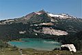
South side of Cloudy Peak, seen from Lyman Lake.

