Comptche, California facts for kids
Quick facts for kids
Comptche
|
|
|---|---|
 |
|

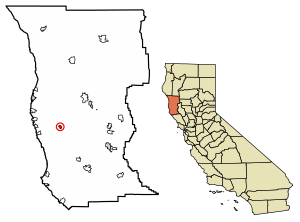
Location in Mendocino County and California
|
|
| Country | |
| State | |
| County | Mendocino |
| Area | |
| • Total | 1.15 sq mi (3.0 km2) |
| • Land | 1.15 sq mi (3.0 km2) |
| • Water | 0.00 sq mi (0 km2) 0% |
| Elevation | 187 ft (57 m) |
| Population
(2020)
|
|
| • Total | 167 |
| • Density | 144.71/sq mi (55.87/km2) |
| Time zone | UTC-8 (PST) |
| • Summer (DST) | UTC-7 (PDT) |
| ZIP code |
95427
|
| Area code(s) | 707 |
| GNIS feature IDs | 255911; 2628722 |
Comptche is a small, quiet place in Mendocino County, California, United States. It's known as an unincorporated community, which means it's not officially a city or town with its own local government. It's also a census-designated place (CDP), which is a special area the government uses to collect information about people.
The name Comptche comes from the Pomo people's word Compatche. This word means "In the valley among the hills." Comptche is located about 17 miles (27 km) southeast of Fort Bragg. It sits at an elevation of 187 feet (57 meters) above sea level.
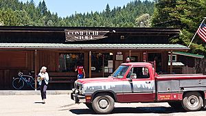
Even though it's small, Comptche has a few important things. There's a primary school for younger kids (kindergarten to third grade). You can also find a small store with a gas pump, a post office, and a church. In 2020, about 167 people lived in Comptche.
Contents
Where is Comptche Located?
Comptche is in the western part of Mendocino County. Its exact location is 39°15′54″N 123°35′28″W / 39.26500°N 123.59111°W. It uses the ZIP code 95427.
Roads and Rivers
Comptche is at a spot where three smaller roads meet.
- The Comptche–Ukiah Road goes west from Comptche for 15 miles (24 km). It leads to Mendocino on State Route 1.
- To the east, Orr Springs Road stretches about 30 miles (48 km) to Ukiah. Ukiah is on U.S. 101. Along this road, you'll pass Montgomery Woods State Natural Reserve.
- Flynn Creek Road goes south from Comptche for about 8 miles (13 km). It connects to State Route 128. This is near the town of Navarro in Navarro River Redwoods State Park.
These roads are important. Flynn Creek Road and the western part of Comptche–Ukiah Road offer another way to travel. They connect Mendocino and the Anderson Valley. This route is especially useful during winter storms. Sometimes, the Navarro River floods Route 128, making it impassable.
Comptche covers an area of about 1.2 square miles (3.1 square kilometers). All of this area is land. The Albion River flows along the southern edge of the community. This river travels west and eventually reaches the Pacific Ocean at Albion.
A Look Back in Time
The Comptche post office first opened in 1877. It closed later that same year but then reopened in 1879. The exact reason for the town's name isn't fully known. However, there was a village of the Pomo people nearby called Komacho. This suggests the name might have come from them.
Who Lives in Comptche?
| Historical population | |||
|---|---|---|---|
| Census | Pop. | %± | |
| 2010 | 159 | — | |
| 2020 | 167 | 5.0% | |
| U.S. Decennial Census | |||
In 2010, the population of Comptche was 159 people. By 2020, it had grown slightly to 167 people. Most people in Comptche live in family homes.
Learning in Comptche
Students in Comptche attend schools that are part of the Mendocino Unified School District.
See also
 In Spanish: Comptche para niños
 | Janet Taylor Pickett |
 | Synthia Saint James |
 | Howardena Pindell |
 | Faith Ringgold |


