
Coolidge, Arizona facts for kids
Quick facts for kids
Coolidge
|
||
|---|---|---|
|
City
|
||

Original 1939 Coolidge High School
|
||
|
||
| Nickname(s):
C-Town
|
||

Location of Coolidge in Pinal County, Arizona
|
||

Coolidge, Arizona
Location in Arizona

Coolidge, Arizona
Location in the United States
|
||
| Country | United States | |
| State | Arizona | |
| County | Pinal | |
| Founded | 1925 | |
| Incorporated | 1945 | |
| Government | ||
| • Type | City | |
| Area | ||
| • Total | 83.05 sq mi (215.11 km2) | |
| • Land | 82.89 sq mi (214.69 km2) | |
| • Water | 0.16 sq mi (0.42 km2) 0% | |
| Elevation | 1,424 ft (434 m) | |
| Population
(2020)
|
||
| • Total | 13,218 | |
| • Density | 159.46/sq mi (61.57/km2) | |
| Time zone | UTC-7 (MST) | |
| • Summer (DST) | no DST | |
| ZIP code |
85128
|
|
| Area code(s) | 520 | |
| FIPS code | 04-15500 | |
| GNIS ID | 2410221 | |

Coolidge is a city in Pinal County, Arizona, in the United States. In 2020, about 13,218 people lived there.
This city is famous for the Casa Grande Ruins National Monument. This special place was the first historic site protected by the United States Government way back in 1892! Coolidge is also home to two important schools: Central Arizona College and the Central Arizona Valley Institute of Technology.
Contents
History of Coolidge
The area where Coolidge is now was once home to the Hohokam people. They were an ancient group from the Sonoran Desert. They built a huge complex with many structures made of a material called caliche. They lived there for over 1,000 years!
The only part of their buildings still standing and protected today is the Casa Grande Ruins National Monument.
How Coolidge Started
The modern city of Coolidge grew because of farming, especially cotton. The city was founded in 1925. A man named R.J. Jones planned out the town during the building of the Coolidge Dam. This dam was built on the nearby Gila River and finished in 1930.
Both the dam and the town were named after Calvin Coolidge. He was the 30th President of the United States. The dam helped turn the sandy desert soil into very rich farmland. Soon, large areas of desert were plowed, and lots of cotton was planted. This made Coolidge a major center for the cotton industry in Arizona. The city officially became a city in 1945.

Coolidge's Economy
For a long time, until the 1950s, Coolidge's economy mostly depended on mining and cotton farming. But since then, the city's economy has grown. It now includes manufacturing (making things), regional trade (buying and selling goods), and services for farmers and their families.
In 2019, a company called Nikola Motor Company bought a large piece of land in Coolidge. They built a factory there to make zero-emissions heavy trucks. This factory can produce 2,500 trucks every year!
Geography of Coolidge
Coolidge covers about 5 square miles (13 square kilometers) of land. It is almost completely flat and has no mountains. The city sits in a fertile valley just south of the Gila River.
You can see the Sacaton Mountains to the west. The Picacho Mountains are visible to the southeast.
Getting Around Coolidge
Arizona State Route 87 and Arizona State Route 287 are main roads that go through Coolidge. These roads connect the city to the Phoenix metropolitan area, Casa Grande, and Eloy. Interstate 10 is about 10 miles (16 km) to the west.
Coolidge is about 56 miles (90 km) southeast of Phoenix. It's also 69 miles (111 km) northwest of Tucson. Casa Grande is 21 miles (34 km) northeast, and Florence is 11 miles (18 km) southwest. The Picacho Reservoir is just 11 miles (18 km) south of town.
Climate in Coolidge
Coolidge has a hot desert climate, which is typical for the Sonoran Desert.
Winters
Winters in Coolidge are usually short and mild. There's lots of sunshine. Daytime temperatures are often between 65°F (18°C) and 75°F (24°C). Nighttime temperatures are usually between 35°F (2°C) and 45°F (7°C). It freezes a few times each year. Rain doesn't happen often, usually only 2 or 3 days a month. The coldest temperature ever recorded in Coolidge was 8°F (-13°C).
Summers
Summers are long and very hot. Temperatures are often between 100°F (38°C) and 110°F (43°C) almost every day from late May to September. Sometimes, temperatures can even go above 115°F (46°C). The hottest temperature ever recorded was 123°F (51°C). Nighttime temperatures are usually above 70°F (21°C). Sometimes, they stay above 80°F (27°C).
Coolidge is affected by the North American Monsoon. This brings short, heavy rain showers and strong winds in the second half of summer. Sometimes, these storms can cause dust storms called haboobs and even flash flooding.
Population of Coolidge
| Historical population | |||
|---|---|---|---|
| Census | Pop. | %± | |
| 1960 | 4,990 | — | |
| 1970 | 5,314 | 6.5% | |
| 1980 | 6,851 | 28.9% | |
| 1990 | 6,934 | 1.2% | |
| 2000 | 7,786 | 12.3% | |
| 2010 | 11,825 | 51.9% | |
| 2020 | 13,218 | 11.8% | |
| 2022 (est.) | 16,711 | 41.3% | |
| U.S. Decennial Census | |||
In 2000, there were 7,786 people living in Coolidge. There were 2,585 households, and 1,938 families. The population density was about 1,549 people per square mile (598 per square kilometer).
About 32.9% of the people were under 18 years old. About 13.4% were 65 years or older. The average age was 31 years.

By 2010, the population of Coolidge had grown to 11,825 people.
Education in Coolidge
Coolidge has several schools for different age groups:
- Coolidge High School: This is a high school located in the center of the city.
- West Elementary School: This school teaches students from kindergarten to 5th grade. It's in the western part of the city.
- Imagine Schools Coolidge Elementary: This is a charter school for kindergarten to 5th grade. It's in the northern part of the city.
- Imagine Prep Coolidge: This is a charter school for grades 6 through 12. It's right next to Imagine Coolidge Elementary.
- Coolidge Junior High School: This school is for grades 6-8.
- Central Arizona College: This is a college in the area.
- Central Arizona Valley Institute of Technology: This is another important school in Coolidge.
Transportation
The City of Coolidge helps people get around.
- The Cotton Express is a local bus service that operates within the city.
- The Central Arizona Regional Transit (CART) provides transportation between Florence, Coolidge, Central Arizona College, and Casa Grande.
Coolidge used to have a train station for Amtrak, but it closed in 1996.
The Coolidge Municipal Airport is about 5 miles (8 km) southeast of the city. It has two asphalt runways. The closest major airports are Phoenix Sky Harbor International Airport and Tucson International Airport. You can use the Casa Grande Shuttle to get to Sky Harbor.
Notable people
Some famous people have connections to Coolidge:
- Duane Eddy – a rock & roll guitarist and record producer who graduated from Coolidge High School.
- Waylon Jennings – a famous singer who is in the Country Music Hall of Fame.
- Sammi Smith – a country music recording artist and songwriter.
Historic properties
- Historic properties in Coolidge, Arizona
-
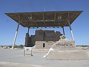
The Casa Grande Ruins are located at Ruins Drive in Coolidge, Az. Built by the Hohokam, the Casa Grande was abandoned around AD/CE. Written historic accounts of the Casa Grande begin with the journal entries of Padre Eusebio Francisco Kino when he visited the ruins in 1694. Listed in the National Register of Historic Places in 1966, and reference #66000192.
-
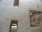
Inside the Casa Grande Big House Ruins
-
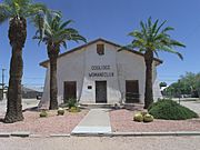
The Coolidge Woman's Club (Building) was built in 1925 and is located at 240 W. Pinkley Ave., Coolidge, Arizona. The building was listed in the National Register of Historic Places in 1990, reference #900015924.
-
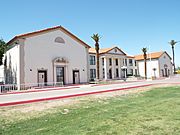
Historic Coolidge High School built in 1939 and NRHP eligible. The building now houses the offices of the Coolidge Unified School District No. 21.


See also
 In Spanish: Coolidge (Arizona) para niños
