
Copiapó Province facts for kids
Quick facts for kids
Copiapó Province
Provincia de Copiapó
|
|||||
|---|---|---|---|---|---|
|
|||||
| Country | |||||
| Region | Atacama | ||||
| Capital | Copiapó | ||||
| Comunas | Copiapó, Caldera, Tierra Amarilla | ||||
| Government | |||||
| • Type | Provincial | ||||
| Area | |||||
| • Total | 32,538.5 km2 (12,563.2 sq mi) | ||||
| Population
(2002 Census)
|
|||||
| • Total | 155,713 | ||||
| • Density | 4.785500/km2 (12.39439/sq mi) | ||||
| Time zone | UTC-4 (CLT) | ||||
| • Summer (DST) | UTC-3 (CLST) | ||||
| Area code(s) | 56 + 52 | ||||
| Website | Official website: http://www.gobernacionchanaral.gov.cl/ | ||||


Welcome to Copiapó Province (which is Provincia de Copiapó in Spanish)! This is one of three provinces located in the northern Chilean region called Atacama. The main city and capital of Copiapó Province is Copiapó.
Contents
Exploring Copiapó Province: Geography and Nature
Copiapó Province is a large area, covering about 32,538.5 square kilometers (that's about 12,563 square miles!). It is the biggest province in the Atacama region.
Where is Copiapó Province Located?
This province has many neighbors! To the north, it shares a border with Chañaral Province. To the northeast, you'll find the country of Argentina. The Tierra Amarilla commune is to the east. South of Copiapó Province is Huasco Province. Finally, to the west, it meets the vast Pacific Ocean and the Caldera commune.
 |
Chañaral commune (Chañaral province) |
Diego de Almagro commune (Chañaral province) |
Argentina | |
| Caldera commune Pacific Ocean |
Tierra Amarilla commune | |||
| Huasco commune (Huasco province) |
Vallenar commune (Huasco province) |
The Copiapó River and Its Importance
The most important river in the province is the Copiapó River. It flows for about 162 kilometers (about 101 miles). The valley around the Copiapó River is very fertile. This means it's great for growing fruits, especially delicious grapes!
People of Copiapó Province: Population Facts
According to the last national census in 2002, about 155,713 people lived in Copiapó Province. This means there were about 4.8 people living in each square kilometer.
The Capital City: Copiapó
The biggest city in the province is Copiapó, which is also its capital. In 2002, about 129,091 people lived in Copiapó city. It's a busy and important center for the province.
How Copiapó Province is Managed: Administration
Copiapó is a province, which is a type of administrative division in Chile. Think of it like a large county or district. It is made up of three smaller areas called communes (comunas in Spanish).
The Role of the Capital City
The city of Copiapó is the capital of the province. This means it's where the main government offices for the province are located. A governor is in charge of running the province.

Communes of Copiapó Province
Here are the three communes that make up Copiapó Province:
| Code | Comuna | Capital | Area (km²) |
Population (2002) |
|---|---|---|---|---|
| 03101 | 4 Copiapó | Copiapó | 16,681.3 | 129,091 |
| 03102 | 3 Caldera | Caldera | 4,666.6 | 13,734 |
| 03103 | 5 Tierra Amarilla | Tierra Amarilla | 11,190.6 | 12,888 |
| Total of the Copiapó province | 32,538.5 | 155,713 | ||
Gallery
-
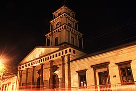
The beautiful Copiapó cathedral at night.
-
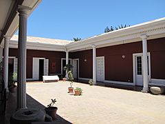
The Atacama museum in Copiapó, where you can learn about the region's history.
-
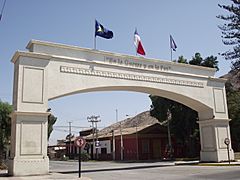
An impressive Arch in Copiapó.


See also
 In Spanish: Provincia de Copiapó para niños
