
Corinth, New York facts for kids
Quick facts for kids
Corinth
Kahcheboncook (Mohawk)
|
|
|---|---|
| Town of Corinth | |

Main Street, Corinth NY
|
|
| Nickname(s):
Gateway to the Adirondacks
|
|

Map highlighting Corinth's location within Saratoga County.
|
|

Corinth
Location in New York
|
|
| Country | United States |
| State | New York |
| County | Saratoga |
| Settled | 1775 |
| Established | 1818 |
| Area | |
| • Total | 58.13 sq mi (150.57 km2) |
| • Land | 56.76 sq mi (147.02 km2) |
| • Water | 1.37 sq mi (3.55 km2) |
| Population
(2020)
|
|
| • Total | 6,500 |
| Time zone | UTC-5 (Eastern (EST)) |
| • Summer (DST) | UTC-4 (EDT) |
| Area code(s) | 518 |
| FIPS code | 36-091-18223 |
| Website | www.townofcorinthny.com |

Corinth is a town in Saratoga County, New York. It is located in the United States. In 2020, about 6,500 people lived here. The town has a village also called Corinth. It sits on the northeastern edge of Saratoga County. This is north of Saratoga Springs. Corinth is known as the "snowshoe capital of the world." It is also home to Palmer Falls. Here, the Hudson River flows through the Palmertown Range.
Contents
What is the History of Corinth?

Early Days and Palmer Falls
Palmer Falls is an area with rushing waterfalls. It had many names before. Some names were "Kah-che-bon-cook" and "The Great Falls of the Hudson." Today, it is named after Beriah Palmer. He once owned land on both sides of the river near the falls.
Around 1763, after the French and Indian War, two brothers, Ebenezer and Edward Jessup, started cutting down trees here. They floated logs down the Hudson River. To get around Palmer Falls, they would stop at "Jessup's Landing." This spot is now a public beach in the Village of Corinth. They would then move the logs onto wagons.
American Revolution and First Settlers
During the American Revolution, the Jessup brothers supported the British. They left for Canada. For a long time, the area was called Jessup's Landing. The first people to settle here permanently arrived around 1777. Joseph Eggleston moved from Wilton to avoid British attacks.
John W. Taylor came to Jessup's Landing around 1808. He helped create the Town of Corinth in 1818. Other early families also settled nearby. Ambrose Clothier moved from Connecticut around 1790. He built a cabin near Lake Bonita. His family was known for playing the fiddle.
Another settlement area was South Corinth. It was first called Chapman's Corners. This area was settled around 1788 by Adam Comstock. He was a politician who served in the New York State Assembly.
How Corinth Got Its Name
The town was officially formed in 1818. It was created from the town of Hadley. The first thing they did was choose a name. Mrs. Washington Chapman was given the honor. She opened her Bible randomly to the Epistle to the Corinthians. That is how the town got its name.
After the American Civil War, many paper mills opened in Corinth. This was after Lumbering had been very important. The town once had over thirty sawmills.
In 1888, the small community of Corinth became an official village. A mapmaker named L.R. Burleigh made a detailed map of Corinth and Palmer Falls that year.
Where is Corinth Located?
The town of Corinth covers about 58.1 square miles (150.6 square kilometers). Most of this area is land. Only a small part is water.
The eastern border of the town is the Hudson River. This river also forms the border with Warren County. The western part of Corinth is inside the Adirondack Park. This is a large protected area.
How Do People Travel in Corinth?
New York State Route 9N is a main road that runs north and south through the town.
The Saratoga and North Creek Railway used to have train stops in Corinth. This train line closed in 2002. This happened when the paper mill also closed down.
What Industries Were Important in Corinth?
Corinth has a history of different industries. As early as 1804, a sawmill was built on the Hudson River at Palmer Falls. Soon after, a gristmill (for grinding grain) and a factory for making wool products opened.
In 1869, the Hudson River Pulp & Paper Company built a mill. They started making paper from wood pulp in 1870. This mill became a very important part of the International Paper Company when it started in 1898. At times, over 1500 people worked there. The mill made special coated paper until it closed in 2002.
Other businesses also operated in Corinth. A shirt factory opened in the 1890s. It was bought by Cluett Peabody & Company in 1899. This factory closed in 1975. The Elixman Paper Core Company made paper cores from 1913 until 1976. There was also a factory that made chairs. Other businesses included sand, crushed-stone, and gravel operations.
In South Corinth, Washington Chapman built a woolen mill in 1805. It later made nuts and bolts. A tannery (for processing animal hides) opened there in 1855. By the 1870s, it processed thousands of hides each year. Nearby sawmills also produced a lot of lumber.
How Many People Live in Corinth?
| Historical population | |||
|---|---|---|---|
| Census | Pop. | %± | |
| 1820 | 1,490 | — | |
| 1830 | 1,412 | −5.2% | |
| 1840 | 1,365 | −3.3% | |
| 1850 | 1,501 | 10.0% | |
| 1860 | 1,558 | 3.8% | |
| 1870 | 1,500 | −3.7% | |
| 1880 | 1,737 | 15.8% | |
| 1890 | 2,124 | 22.3% | |
| 1900 | 3,104 | 46.1% | |
| 1910 | 3,102 | −0.1% | |
| 1920 | 3,696 | 19.1% | |
| 1930 | 3,760 | 1.7% | |
| 1940 | 4,478 | 19.1% | |
| 1950 | 4,879 | 9.0% | |
| 1960 | 5,167 | 5.9% | |
| 1970 | 5,442 | 5.3% | |
| 1980 | 5,216 | −4.2% | |
| 1990 | 5,935 | 13.8% | |
| 2000 | 5,985 | 0.8% | |
| 2010 | 6,531 | 9.1% | |
| 2020 | 6,500 | −0.5% | |
| U.S. Decennial Census | |||
In 2000, there were 5,985 people living in the town. There were 2,331 households. About 1,662 of these were families. The population density was about 105 people per square mile.
About 32.6% of households had children under 18. Most households (55.2%) were married couples. About 23.4% of households were single people. The average household had 2.57 people.
The population was spread out by age. About 26% were under 18. About 14.2% were 65 or older. The average age was 38 years old.
The median income for a household was $35,199. For families, it was $41,732. About 11.9% of the population lived below the poverty line. This included 14.7% of those under 18.
What are the Communities and Places in Corinth?
- Black Pond – This is a lake west of the village of Corinth.
- Corinth: This is a village by the Hudson River. It is in the eastern part of the town. You can find it on NY-9N.
- Daly's Creek: This is a stream in the northwestern part of Corinth. It flows into the Great Sacandaga Lake.
- Efner Lake: This lake is near the northern town line. It is south of County Road 10.
- Hunt Lake: This lake is located east of Efner Lake.
- Jenny Lake: Another lake found east of Efner Lake.
- Lake Bonita: This lake is in the southeastern corner of the town.
- Mount McGregor: This is a mountain in the southeastern part of the town.
- Palmer: This is a small community east of Corinth village. It is on County Road 24.
- Randall Corner: This community is in the southeastern part of the town. It is on County Road 25.
- South Corinth: This is a community near the southern town line. It is on NY-9N.
- Woodland Lake: This lake is southeast of Corinth village.
- Alpine Lake
Images for kids
-
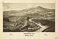
Perspective map of Corinth and Palmer Falls by L.R. Burleigh from 1888 with a list of landmarks
-
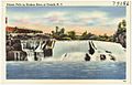
Palmer Falls c.1930-1945
See also
 In Spanish: Corinth (Nueva York) para niños
