
Corroirie facts for kids
Quick facts for kids La Corroirie |
|
|---|---|
_(18833885679).jpg)
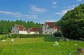
General view of the buildings from the south.
|
|
| General information | |
| Type | Fortified monastic farm |
| Architectural style | Romanesque architecture, Gothic, French Renaissance |
| Address | Loches to Montrésor Route |
| Town or city | Chemillé-sur-Indrois commune, Indre-et-Loire department, Centre-Val de Loire region. |
| Country | France |
| Coordinates | 47°09′03″N 01°08′24″E / 47.15083°N 1.14000°E |
| Construction started | From the 17th to 18th century |
| Owner | Private land |
| Awards and prizes | Monument historique (1926, gateway, church and prison) Monument historique (2015, whole site) Classed site (1947, La Corroirie, chartreuse and surroundings) |
La Corroirie is an old fortified farm in France, near the village of Chemillé-sur-Indrois. It was once part of a large monastery called the Chartreuse du Liget. Imagine a place that was both a busy farm and a strong fortress!
It was likely built around the late 1100s. It became the "lower house" for the monastery, where lay brothers (monks who focused on practical tasks) managed huge farms. The monastery owned nearly 1,500 hectares (about 3,700 acres) of land! Over the centuries, La Corroirie grew bigger and stronger. It was fortified during wars like the Hundred Years' War and the French Wars of Religion.
By the 1500s, it looked like a true stronghold with a huge fortified gate. In the late 1600s, the monks moved to the main monastery, and La Corroirie became just a farm. But it was special because it also had legal rights over its land, even having its own prison! This shows it was an important place from the Middle Ages until the French Revolution.
When the French Revolution happened, the monks left, and La Corroirie was sold. Luckily, it wasn't badly damaged. People still live there today, keeping it well-maintained. Its old gate, church, and prison were recognized as historic monuments in 1926. Later, in 2015, the entire site became a protected historic monument.
Contents
Discovering La Corroirie

La Corroirie is located in the Chemillé-sur-Indrois area, about 3 kilometers (1.8 miles) southwest of the main town. Its buildings are built into the side of a hill, next to a small river valley. The main monastery, the Chartreuse du Liget, is about 1.1 kilometers (0.7 miles) away.
South of the buildings, there's a pond called Corroirie pond. The monks created this pond to help with their farming. A road now runs between the pond and the buildings. Old maps, like the Cassini map, show how the area used to look. The limited space for building might be why the buildings were made taller over time, to fit more people and activities.
The name "Corroirie" comes from old words. It likely means a "lower house" of a monastery, where manual and farm work was done. These places were often close to the land and housed the lay brothers. It's a name that fits its history as a working farm for the monks.
A Look Back in Time
How it Started

The land where the monastery stands was bought by Henry II of England between 1176 and 1183. He then gave it to a small group of monks, asking them to join the Carthusian order. This is when the Saint-Jean du Liget chapel and the first monastery buildings were constructed.
Before the Carthusians arrived, the area of La Corroirie was called Craçay. It was a separate piece of land that a local lord, Foulques de Craçay, gave to the monks around 1200. Even though there were some arguments about this gift after Foulques died, it was confirmed.
It's hard to know the exact date La Corroirie was founded because old records are missing. However, we know its church was dedicated by a bishop in 1206. This suggests that the first buildings were put up between the late 1100s and early 1200s. These early structures might have been a pantry, a dormitory, or a dining hall. The church was likely started just before the other buildings.
La Corroirie was important because it was on the road between two strong castles, Loches and Montrésor. It helped the powerful Anjou family control the area. It was also the center for managing the monastery's lands, showing a clear separation between the monks' spiritual life and the practical, everyday work.
Growing and Getting Stronger
Medieval Times


The monastery really thrived between the mid-1200s and mid-1300s. Over a hundred gifts of land from local lords and even royalty made its estate very rich. By the 1600s, the land managed by La Corroirie for the monastery covered almost 1,480 hectares (3,657 acres) of fields, meadows, vineyards, woods, and ponds. It also managed other farms and lands up to 15 kilometers (9 miles) away.
To handle all this activity, La Corroirie's buildings were greatly improved. Existing buildings were made bigger or taller to house more lay brothers. A large hall was built, possibly for meetings or as a court. The monastery had the right to hold its own court and make legal decisions, which was confirmed in 1352. Records show that La Corroirie's legal officers sometimes had disagreements with those from the nearby town of Loches.
It's likely that the farm had a walled courtyard with a grand entrance gate facing the road. However, no traces of this early gate remain today.
Tough Times and Fortifications
In 1361, during the Hundred Years' War, an English-allied army attacked La Corroirie. The monks from the main monastery had hidden there, but they managed to escape through an underground passage to Loches. Another attack happened in 1392.
After these attacks, a new defensive gate with a portcullis was built in the west building. This replaced the old entrance from the south, which was sealed off. Once the war ended, the monks returned, and a big project began to raise the ground level around the buildings by about 1.5 meters (5 feet). This was probably to protect La Corroirie from floods. The buildings were also expanded again. An extra floor was added to the church, possibly for dormitories. By the mid-1400s, the church's attic was turned into a bastion (a strong defensive part) with arrowslits (narrow openings for shooting arrows) and a walkway for defenders. In 1432, King Charles VII even sent a small group of soldiers to protect La Corroirie and the main monastery.
The new gatehouse was not just for defense. It also pointed towards the main monastery, showing the strong connection between the two places. It might have also made it easier for monks to quickly reach safety during an attack.
Attacks During the Wars of Religion
.jpg)
The French Wars of Religion caused serious problems for the monastery. In 1562, the head monk was killed, and the monastery was completely destroyed. It's unclear if this attack was by organized Protestants or by independent groups of looters. The monks had to leave for a while. In 1584, more attacks happened at La Corroirie and nearby farms. In 1589, a group called the "preneurs de Barbetz" attacked La Corroirie, with local farmers joining in the looting.
After these events, it was decided to turn La Corroirie into a strong fortified house. A fortified gatehouse with a drawbridge was built at the entrance. A bretèche (a small projection from a wall, with openings for dropping things on attackers) was added. Towers and watchtowers were built around the walls, and a moat (a deep, wide ditch, usually filled with water) was dug. The Corroirie pond was likely built at this time to keep the moat filled with water. Finally, a turret-shaped prison was built inside the walls, away from the other buildings. This work continued into the early 1600s.
Changing Roles
The late 1600s marked a big change for La Corroirie. Two watermills were built in 1671 and improved later. The Corroirie pond made sure the mills had a steady supply of water. The church was closed to worshipers around 1674, and the religious workers who lived at La Corroirie moved to the main monastery. This change meant La Corroirie focused mainly on farming, losing its original religious purpose.
The buildings were made more comfortable with better heating and access to upper floors. However, we don't know exactly when these improvements were made. They might have been part of a larger renovation project for the main monastery that was stopped by the French Revolution.

After the French Revolution, the monastery system was abolished. La Corroirie, already mostly a farm, fully became one. In 1789, only two lay brothers managed La Corroirie, living at the main monastery. The monks left in early 1791, and La Corroirie was sold by the government on June 1, 1791.
Ownership changed several times, and the property was even divided. In 1899, the Marsay family bought it. Since then, La Corroirie has stayed in this family and is still lived in today, which has helped keep the buildings in good condition. Some parts were even turned into guest rooms in the 2000s. Even with these changes, the house still looks much like it did in the late Middle Ages.
In 1926, the fortified gate, chapel, and old prison were listed as historic monuments. In 2015, the entire site was added to this list. In 1947, La Corroirie, along with the main monastery and surrounding land, became a protected natural site.
What the Buildings Look Like

Many buildings have been built at La Corroirie over time. Some have changed their use, and others have been partly destroyed. This makes it tricky to map out how they evolved. However, because La Corroirie has been continuously lived in since the Middle Ages, the buildings are generally in good shape.
The Fortified Gate

The impressive fortified gateway was likely built around 1575. Its style and the age of its wood (found through tree-ring dating) confirm it's from the late 1500s. This gatehouse replaced an older defensive gate.
It's a two-story tower with machicolations (openings for dropping things on attackers) on its west side. You enter through two gates: one for carts and one for people. Both had a drawbridge over the moat. The walls are made of rough stone, with large, smooth tufa blocks at the corners. The roof is covered with tiles.
Above the doors, the first floor held the machinery for the drawbridges. The second floor was a lookout room, perhaps for soldiers. It even had a small sink!
The Church

This building has changed the most over time and has been studied a lot. Its construction happened in five main stages, which you can clearly see from the south side.
- First Phase: The first church had a main hall (nave) and a choir area. The main entrance was at the west end. It was about 15.5 meters (51 feet) long and 6 meters (20 feet) wide. The floor was later raised by 1.5 meters (5 feet). The outside walls are in Romanesque style, but the arched ceilings (vaults) are Gothic. This first part was built between the late 1100s and early 1200s. Inside, you can still see colorful decorations and painted patterns on the ceilings. The church also has a Renaissance baptismal font.
- Second Phase: In the early 1400s, the church's nave was made taller by adding another story. The purpose of this floor is unknown, but it might have been a dormitory for the growing number of workers. You can see the different types of stone used for the original walls and the added upper story.
- Third Phase: In the late 1400s, the choir area was also made taller and, like the nave, turned into a strong defensive point. This is when "exclamation-point-shaped" arrowslits were added, allowing defenders to shoot arrows or firearms.
- Fourth Phase: Before 1570, another building was added, connecting the church to the cellar building.
- Fifth Phase: When La Corroirie became a fortified house in the late 1500s, a few more arrowslits were added to the church. These were designed for larger weapons and helped cover any "blind spots" in the defense.
The Prison

A round tower, about 5 meters (16 feet) wide and 7 meters (23 feet) tall, stands alone in the northern part of the complex. It's believed to be a former prison because of its unique design. It has two cells, one above the other, each about 2.7 meters (9 feet) wide.
There's only one door on the upper floor, and it could only be locked from the outside. Small openings (like arrowslits) and windows were originally fitted with strong iron bars. Each cell also had a simple toilet built into the wall.
While some thought it might have been an ice-house, its layout doesn't support that idea. It's most likely a prison built in the late 1500s. It might also have been used for processing hemp (a plant used for fiber) at other times, as hemp farming was common in this area.
Other Important Buildings
North of the church, there's a large building that served as a cellar. It was built around the same time as the church and has been changed and made taller many times. In the late 1600s, two flour mills were built on its eastern side, powered by water from the Corroirie pond. The upper floors of this building are no longer there.
A large building on the west side of the site was built around the late 1200s. It might have been a meeting hall for the monks or a court. It was later changed and possibly used as living quarters for soldiers when La Corroirie was fortified. In the 1300s, the northern part of this building was turned into a gatehouse with a portcullis. This made it easier to create a new main entrance using existing structures. Before the French Revolution, this building was made taller and divided into many rooms.
Further north, another building, possibly the monks' dining hall (refectory), was one of the first to be built. It was later rebuilt and made taller, perhaps to host visitors.
Even further north, there's a two-story building whose purpose isn't fully known. It might have been the monastery's outbuildings with the abbot's (head monk's) home above. It was built in the early 1400s.
Two towers remain from when La Corroirie became a fortified house. The northern tower is mostly ruins, but the southern tower is still in good condition.
After the French Wars of Religion, the monastery's walls were extended to the north and east. The steep hillside on one side naturally protected La Corroirie, but it was reinforced with a wall and supports. This wall is still visible near the prison.
An underground passage, dug into the hillside, has a large room and several smaller passages. One leads outside on the northern side. It was explored in 2009. However, there's no proof that this was the secret passage the monks used to escape in 1361.
La Corroirie in Arts and Culture

_(18832310838).jpg)

La Corroirie has been featured in movies and books!
- The short film Les Condiments irréguliers, based on the life of a famous French noblewoman, was partly filmed at La Corroirie in 2009.
- In 2015, La Corroirie was used as a filming location for several scenes, including a dramatic burning scene, in the American film Joan of Arc, which tells the story of Joan of Arc.
- Several parts of Mary Play-Parlange's crime novel Clair-obscur en chartreuse: une enquête à tiroirs (2013) take place at La Corroirie or talk about its history.
Images for kids
-
General view of the buildings from the south.
See also
