
Cozy Dell Shale facts for kids
Quick facts for kids Cozy Dell ShaleStratigraphic range: Eocene |
|
|---|---|

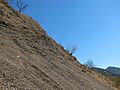
Talus slope on an outcrop of Cozy Dell Shale, Santa Ynez Mountains, California.
|
|
| Type | sedimentary |
| Underlies | Coldwater Sandstone |
| Overlies | Matilija Sandstone |
| Thickness | 350 to 4,000 feet (107 to 1,219 m) |
| Lithology | |
| Primary | shale |
| Other | minor sandstone beds, calcareous nodules |
| Location | |
| Region | Coastal southern California |
| Country | United States |
| Type section | |
| Named for | Cozy Dell Canyon, Ventura County |
| Named by | Kerr and Schenck (1928) |

The Cozy Dell Shale is a special type of rock layer found in California. It formed during the middle Eocene epoch, which was about 34 to 56 million years ago. This rock layer is mostly made of shale, which is a fine-grained sedimentary rock.
You can find the Cozy Dell Shale in the Santa Ynez Mountains and Topatopa Mountains in California. It stretches from Ventura County all the way west to near Point Arguello, which is north of Santa Barbara. Because this shale easily breaks down into clay-rich soil, it often forms areas with thick chaparral plants. These areas are usually found in dips or "saddles" between the taller peaks made of harder rocks like the Matilija and Coldwater formations.
Contents
Where to Find the Cozy Dell Shale


The Cozy Dell Shale was first described in 1928. Later, in 1966, a geologist named Dibblee officially named it a "formation." He named it after Cozy Dell Canyon, which is near Ojai in Ventura County. This canyon is where the rock layer was first studied in detail, making it its "type locality."
You can see the Cozy Dell Shale continuously in the mountains north and east of Ojai. It shows up along the southern side of the Topatopa Mountains in Ventura County. It also continues west along the southern side of the Santa Ynez Mountains into Santa Barbara County.
The thickness of the Cozy Dell Shale changes quite a bit. It tends to get thicker as you go from east to west. In the Santa Ynez Mountains, it's usually about 1,700 feet (518 m) thick. However, it can be as thick as 4,000 feet (1,219 m) west of San Marcos Pass. In some offshore oil fields, it can be much thinner, sometimes only 50 feet (15 m) or 350 feet (107 m) thick.
What the Cozy Dell Shale Looks Like
The Cozy Dell Shale is typically gray to dark gray. It's made of fine clay and silt particles. When it's exposed to the weather, it often turns brown or olive green. In some places, you might find small layers of sandstone within the shale. West of San Marcos Pass, there are even some areas with conglomerate, which is a rock made of larger, rounded pebbles.
When this shale is exposed to the air and rain, it quickly breaks down into a soil rich in clay. This type of soil is perfect for growing dense chaparral plants. Since the Cozy Dell Shale is often found between harder rock layers like the Matilija and Coldwater sandstones, and these layers are often tilted upright, the softer Cozy Dell Shale erodes faster. This creates natural passes and saddles (low points) between the higher peaks and ridges formed by the tougher sandstone units.
Ancient Life and How It Formed
Scientists study tiny fossils in the Cozy Dell Shale to learn about its age and how it formed. These tiny fossils are mainly planktonic (floating) foraminifera, which are single-celled organisms with shells. These fossils tell us that the Cozy Dell Shale formed during the Lutetian stage of the middle Eocene epoch.
While the formation has many tiny fossils, larger fossils are rare in the western parts of Santa Barbara County. However, in the Topatopa Mountains to the east, near Ojai, some larger fossils have been found. These include ancient sea creatures like molluscs, starfish, and brittle stars, as well as plant imprints. These larger fossils suggest that this area was once a shallow ocean close to an ancient shoreline.
The Cozy Dell Shale formed during a time when the Eocene sea in the California region was at its largest and deepest. This means that only the very finest sediments, mostly a muddy material containing mica, reached the bottom of the ocean. The sediments also had a good amount of organic material (up to 3% or more). This suggests that many tiny organisms lived there, and the ocean floor had low oxygen levels. Low oxygen helps preserve organic matter. All this evidence tells us that the Cozy Dell Shale was laid down in an ocean basin. The shoreline was to the east and north, and the water got deeper towards the west, possibly over a thousand feet deep.
Earth's Magnetic History in the Rocks
Scientists can study the Earth's ancient magnetic field preserved in rocks, a method called magnetostratigraphy. Recent studies show that the Cozy Dell Shale at its original location was deposited between about 46 and 42 million years ago. This matches the Lutetian time period.
These magnetic studies also show something very interesting: the block of Earth's crust where the Cozy Dell Shale formed has rotated! It has turned clockwise by about 100 degrees since the Eocene. This means that features in the rock that now run east-west were originally oriented north-south.
Why the Cozy Dell Shale is Important
The Cozy Dell Shale is important because it's often found with sandstone layers that can contain oil and natural gas. In places where this shale is deep underground, both on land and offshore in the Santa Barbara Channel, it acts like a "cap rock." This means it's very dense and doesn't let fluids pass through easily. This allows oil and gas to be trapped in the more porous sandstone layers below it.
However, in a few offshore oil fields, some parts of the Cozy Dell Shale itself can hold oil. For example, in the now-closed Cuarta field near Gaviota, the Cozy Dell Shale had some thinner sandstone layers within it. These layers produced oil from about 7,000 feet (2,134 m) below the ocean floor. Even though there's no oil or gas being produced from the Cozy Dell Shale on land, some geologists believe that its high organic content means it could be a "source rock." This means it might have been the original source of the oil found in other rock units.
Images for kids
-
Talus slope on an outcrop of Cozy Dell Shale, Santa Ynez Mountains, California.
