
Crocker Mountain (Maine) facts for kids
Quick facts for kids Crocker Mountain |
|
|---|---|

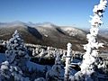
Crocker Mountain (center) seen from Sugarloaf ski resort
|
|
| Highest point | |
| Elevation | 4,229 ft (1,289 m) |
| Prominence | 1,214 ft (370 m) |
| Listing | New England 4000 footers |
| Geography | |

Crocker Mountain
Location in Maine
|
|
| Topo map | USGS Black Nubble |
Crocker Mountain is a tall peak in Maine, United States. It stands at about 4,228 ft (1,289 m) high. This mountain is located in Carrabassett Valley, Franklin County. Crocker Mountain is the fourth highest mountain in Maine. It is part of the famous Appalachian Mountains.
Contents
About Crocker Mountain
Crocker Mountain is a very important part of Maine's natural landscape. Only Katahdin (with its Baxter and Hamlin peaks) and Sugarloaf Mountain are taller. This mountain is also part of the huge Appalachian Mountains range. This mountain range stretches along the eastern side of North America.
The Appalachian Trail
A very long hiking path called the Appalachian Trail (AT) goes right over Crocker Mountain. The AT is a special trail that is about 2,170 mi (3,490 km) long. It stretches all the way from Georgia to Maine. Many hikers enjoy walking parts of this famous trail.
Crocker Cirque
Between the main peak of Crocker Mountain and a smaller peak called South Crocker Mountain, there is a special bowl-shaped area. This area is called "Crocker Cirque." It was formed by glaciers long ago. Inside Crocker Cirque, you can find a small pond. Hikers can reach this interesting spot by following the Appalachian Trail.
Water Flowing from the Mountain
Water from Crocker Mountain flows in different directions. Brooks on the east side of the mountain feed into the Carrabassett River. This river then flows into the Kennebec River. Finally, the water reaches the Gulf of Maine.
On the northwest side, water drains into Stoney Brook. This water then goes into Stratton Brook and Flagstaff Lake. From there, it flows into the Dead River, which is another river that joins the Kennebec. Water from the southwest side of Crocker Mountain flows into Nash Stream. This stream then joins the South Branch of the Dead River.
Images for kids
-
Crocker Mountain (center) in winter

