
Crossville, Tennessee facts for kids
Quick facts for kids
Crossville
|
|||
|---|---|---|---|

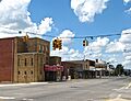
Main Street in Downtown Crossville
|
|||
|
|||

Location of Crossville in Cumberland County, Tennessee
|
|||
| Country | United States | ||
| State | Tennessee | ||
| County | Cumberland | ||
| Established | 1856 | ||
| Incorporated | 1901 | ||
| Named for | Intersection of two early roads | ||
| Area | |||
| • Total | 20.86 sq mi (54.03 km2) | ||
| • Land | 20.45 sq mi (52.95 km2) | ||
| • Water | 0.42 sq mi (1.08 km2) | ||
| Elevation | 1,857 ft (566 m) | ||
| Population
(2020)
|
|||
| • Total | 12,071 | ||
| • Density | 590.41/sq mi (227.96/km2) | ||
| Time zone | UTC-6 (Central (CST)) | ||
| • Summer (DST) | UTC-5 (CDT) | ||
| ZIP codes |
38555, 38557, 38558, 38571, 38572
|
||
| Area code(s) | 931 | ||
| FIPS code | 47-18540 | ||
| GNIS feature ID | 1306203 | ||


Crossville is a city in Tennessee, United States. It is the main town, or county seat, of Cumberland County. In 2020, about 12,071 people lived in Crossville.
Contents
History of Crossville
Crossville grew up at a special meeting point of two old roads. One road, called the Great Stage Road, connected the Knoxville area with the Nashville area. The other, the Kentucky Stock Road, was used by people moving cattle between Middle Tennessee and Kentucky. These old roads are now similar to modern US-70 and US-127 highways.

Around the year 1800, an early American settler named Samuel Lambeth opened a store at this important crossroads. The small community that formed around his store was first known as Lambeth's Crossroads. This store was located where Main and Stanley Streets meet today. By the 1830s, when a post office was set up, the community had started calling itself "Crossville." In the early 1850s, a merchant from nearby Sparta, James Scott, bought Lambeth's store and renamed it Scott's Tavern.
When Cumberland County was officially created in 1856, Crossville was chosen as the county seat. This was because it was close to the center of the new county. James Scott gave 40 acres (16 ha) of land for building a courthouse and a town square.
During the American Civil War, Crossville and Cumberland County faced many challenges. The well-known roads made the area easy for both Union and Confederate soldiers, and even small groups of guerrilla fighters, to pass through. Families and communities were divided, and people suffered. The county sent soldiers to both sides of the conflict.
After World War I, the new U.S. 70 highway helped connect Crossville to bigger markets. This made it easier for the town to sell its farm products and other goods. More highways built after World War II also improved travel and trade in the area.
During the Great Depression, the government started a special housing project south of Crossville. It was called the Cumberland Homesteads. The goal was to give small farms to hundreds of families who were struggling. The recreation area from this project later became Cumberland Mountain State Park. In 1934, First Lady Eleanor Roosevelt even visited Crossville and the Cumberland Homesteads Project.
Crossville's Geography

Crossville is located right in the middle of Cumberland County. It sits on top of the Cumberland Plateau. The Obed River starts near Crossville and flows through a deep gorge north of the city. Crossville is about halfway between the eastern and western edges of the plateau.
There are several small lakes around Crossville. These include Lake Tansi to the south, Lake Holiday to the west, and Byrd Lake at Cumberland Mountain State Park. The city's average elevation is about 1,890 feet (576 m) above sea level.
Crossville grew because it was at the intersection of two major old roads. These roads were later improved and paved. Today, two major federal highways, U.S. Route 70 (east-west) and U.S. Route 127 (north-south), follow these old routes. Interstate 40 also passes through the northern part of Crossville. Crossville is about 35 miles (56 km) east of Cookeville. It is also about 80 miles (130 km) north of Chattanooga and 70 miles (110 km) west of Knoxville.
The United States Census Bureau says Crossville covers an area of 20.3 square miles (52.7 km2). Most of this area, 19.9 square miles (51.7 km2), is land. The rest, 0.4 square miles (1.0 km2), is water.
Crossville's Climate
Crossville has a humid subtropical climate. This means it has warm summers and cool winters. The city's high elevation on the Cumberland Plateau helps to keep temperatures milder. It rains a lot in Crossville, with about 62.57 inches (1,590 mm) of rain each year. This rain is spread out evenly through the year, though early autumn is a bit drier. Snowfall is common, with about 14.1 inches (36 cm) of snow each year.
| Climate data for Crossville, Tennessee (1991–2020 normals, extremes 1912–present) | |||||||||||||
|---|---|---|---|---|---|---|---|---|---|---|---|---|---|
| Month | Jan | Feb | Mar | Apr | May | Jun | Jul | Aug | Sep | Oct | Nov | Dec | Year |
| Record high °F (°C) | 81 (27) |
77 (25) |
82 (28) |
91 (33) |
95 (35) |
102 (39) |
102 (39) |
102 (39) |
103 (39) |
90 (32) |
80 (27) |
73 (23) |
103 (39) |
| Mean maximum °F (°C) | 63.5 (17.5) |
66.7 (19.3) |
74.0 (23.3) |
79.9 (26.6) |
83.8 (28.8) |
88.5 (31.4) |
90.4 (32.4) |
89.7 (32.1) |
87.6 (30.9) |
81.1 (27.3) |
72.3 (22.4) |
64.3 (17.9) |
91.9 (33.3) |
| Mean daily maximum °F (°C) | 41.6 (5.3) |
45.4 (7.4) |
53.6 (12.0) |
63.5 (17.5) |
71.6 (22.0) |
78.5 (25.8) |
81.8 (27.7) |
81.1 (27.3) |
75.9 (24.4) |
65.7 (18.7) |
54.1 (12.3) |
45.1 (7.3) |
63.2 (17.3) |
| Daily mean °F (°C) | 33.4 (0.8) |
36.7 (2.6) |
44.3 (6.8) |
53.5 (11.9) |
61.8 (16.6) |
69.0 (20.6) |
72.5 (22.5) |
71.4 (21.9) |
65.6 (18.7) |
54.8 (12.7) |
44.4 (6.9) |
37.0 (2.8) |
53.7 (12.1) |
| Mean daily minimum °F (°C) | 25.1 (−3.8) |
28.0 (−2.2) |
35.0 (1.7) |
43.5 (6.4) |
52.0 (11.1) |
59.6 (15.3) |
63.2 (17.3) |
61.7 (16.5) |
55.3 (12.9) |
43.8 (6.6) |
34.6 (1.4) |
28.9 (−1.7) |
44.2 (6.8) |
| Mean minimum °F (°C) | 4.5 (−15.3) |
9.2 (−12.7) |
17.2 (−8.2) |
28.2 (−2.1) |
36.1 (2.3) |
48.7 (9.3) |
55.2 (12.9) |
53.7 (12.1) |
41.1 (5.1) |
27.9 (−2.3) |
18.9 (−7.3) |
11.3 (−11.5) |
1.4 (−17.0) |
| Record low °F (°C) | −25 (−32) |
−15 (−26) |
−6 (−21) |
14 (−10) |
28 (−2) |
33 (1) |
40 (4) |
41 (5) |
27 (−3) |
15 (−9) |
−7 (−22) |
−17 (−27) |
−25 (−32) |
| Average precipitation inches (mm) | 5.49 (139) |
5.66 (144) |
6.08 (154) |
6.07 (154) |
5.35 (136) |
5.27 (134) |
5.31 (135) |
4.14 (105) |
4.28 (109) |
3.68 (93) |
4.70 (119) |
6.54 (166) |
62.57 (1,589) |
| Average snowfall inches (cm) | 3.5 (8.9) |
4.4 (11) |
2.7 (6.9) |
0.2 (0.51) |
0.0 (0.0) |
0.0 (0.0) |
0.0 (0.0) |
0.0 (0.0) |
0.0 (0.0) |
0.0 (0.0) |
0.2 (0.51) |
3.1 (7.9) |
14.1 (36) |
| Average precipitation days (≥ 0.01 in) | 15.2 | 13.2 | 14.3 | 13.1 | 13.6 | 13.3 | 12.8 | 10.9 | 9.6 | 9.8 | 11.4 | 14.0 | 151.2 |
| Average snowy days (≥ 0.1 in) | 4.1 | 3.2 | 1.4 | 0.1 | 0.0 | 0.0 | 0.0 | 0.0 | 0.0 | 0.0 | 0.2 | 2.4 | 11.4 |
| Source: NOAA | |||||||||||||
Crossville's Population and People
| Historical population | |||
|---|---|---|---|
| Census | Pop. | %± | |
| 1870 | 95 | — | |
| 1880 | 99 | 4.2% | |
| 1890 | 266 | 168.7% | |
| 1910 | 763 | — | |
| 1920 | 948 | 24.2% | |
| 1930 | 1,128 | 19.0% | |
| 1940 | 1,511 | 34.0% | |
| 1950 | 2,291 | 51.6% | |
| 1960 | 4,668 | 103.8% | |
| 1970 | 5,381 | 15.3% | |
| 1980 | 6,394 | 18.8% | |
| 1990 | 6,930 | 8.4% | |
| 2000 | 8,981 | 29.6% | |
| 2010 | 10,795 | 20.2% | |
| 2020 | 12,071 | 11.8% | |
| Sources: | |||
Who Lives in Crossville? (2020 Census)
| Race | Number | Percentage |
|---|---|---|
| White (non-Hispanic) | 10,572 | 87.58% |
| Black or African American (non-Hispanic) | 111 | 0.92% |
| Native American | 25 | 0.21% |
| Asian | 193 | 1.6% |
| Pacific Islander | 1 | 0.01% |
| Other/Mixed | 404 | 3.35% |
| Hispanic or Latino | 765 | 6.34% |
Based on the 2020 United States census, Crossville had 12,071 people. There were 5,040 households and 2,777 families living in the city.
Fun Places to Visit in Crossville


- Cumberland Mountain State Park is just south of Crossville. It's a great place for outdoor activities.
- The Cumberland Homesteads are also south of Crossville. This area has a unique history from the Great Depression.
- The Native Stone Museum is in an old Tennessee Highway Patrol station. It shows off Crab Orchard Stone, a special local building material. Many buildings in Crossville are made from this stone.
- The Palace Theatre opened in 1938. It is still used today for movies, shows, and meetings.
- The United States Chess Federation used to have its main office in Crossville. They moved there in 2005 but later moved to St. Louis in 2022.
- The Highway 127 Corridor Sale is held every August. It's known as the world's largest yard sale!
- The Cumberland County Playhouse is a big professional theater in rural Tennessee. It's one of the largest in rural America. They put on many shows for over 165,000 visitors each year.
- Crossville is known as "the golf capital of Tennessee." It has 12 different golf courses for people to play on.
- The Cumberland County Fair happens every August. It's a fun event for everyone.
- The Art Circle Public Library is a place where you can find books and learn.
Famous People from Crossville
- Mandy Barnett – a country music singer and actress.
- Julie Ann Emery – an actress who grew up in Crossville.
- Stormi Henley – she was Miss Tennessee Teen USA in 2009 and later Miss Teen USA 2009.
- Milo Lemert – he received the Medal of Honor after he died for his brave actions in World War I. He is buried in Crossville.
- Earl Lloyd – the first African-American person to play in an NBA basketball game.
- Thomas Shadden – a politician who was a member of the Tennessee General Assembly and also Crossville's mayor.
- Michael Sims – a well-known writer of nonfiction books.
- Charles Edward Snodgrass – a U.S. representative.
- Michael Turner – a comic book artist and president of Aspen MLT.
- Marjorie Weaver – a film actress.
Images for kids
-
Main Street in Downtown Crossville
-

Crossville City Flag
-
Crossville City Seal
-

Location of Crossville in Cumberland County, Tennessee
See also
 In Spanish: Crossville (Tennessee) para niños
