
Crystal, Gunnison County, Colorado facts for kids
Quick facts for kids
Crystal, Colorado
|
|
|---|---|
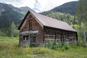
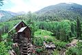
The Crystal Club building, 2015
|
|

Crystal, Colorado
Location in Colorado

Crystal, Colorado
Location in the United States
|
|
| Country | United States |
| State | Colorado |
| County | Gunnison |
| Elevation | 8,951 ft (2,728 m) |
| GNIS feature ID | 175564 |
Crystal (also known as Crystal City) is a fascinating ghost town located high in the Elk Mountains of Colorado. It sits along the upper Crystal River in Gunnison County. You can find it about 6 miles (10 km) east of Marble and 20 miles (32 km) northwest of Crested Butte. The roads leading to Crystal are often rough and require a four-wheel-drive vehicle.
Crystal started as a busy mining camp in 1881. After many years, most people left by 1917. The town's post office was open from 1882 to 1909. Today, many of the old buildings still stand. Only a few people live in Crystal, and they are usually there only during the summer months.
Contents
History of Crystal
In 1874, a geologist named Sylvester Richardson found promising silver deposits near the Crystal River. Soon after, the native Ute people moved from the area. This opened the way for miners to start digging for valuable metals. A new mining camp began in 1880.
Just one year later, on August 6, 1881, the local court officially made Crystal City a town. At its busiest in the mid-1880s, Crystal had over 500 residents. It was a lively place with a post office, newspapers, a pool hall, and even a special men's club called the Crystal Club. There were also barber shops, saloons, and hotels.

Mining and Challenges
During the 1880s and 1890s, miners cleared land by setting fires. This helped them access the mining areas. Several mines near Crystal became very productive. The Black Queen, Lead King, and Sheep Mountain Tunnel were among the largest. Miners mostly found silver, lead, and zinc.
However, getting the ore out of the valley was a big problem. The closest train stations were 20 miles (32 km) away in Crested Butte and 34 miles (55 km) away in Carbondale, Colorado. The roads from Crystal were not much more than trails. Even after years of work, they remained narrow wagon trails. Most ore was carried by "jack trains" – long lines of up to a hundred mules!
Crystal's remote location made it hard to succeed. Transporting ore and bringing in supplies was tough in summer. In winter, it was nearly impossible due to deep snow and dangerous avalanches. These transportation problems cut into profits. By 1889, Crystal's population had dropped to less than 100 people in winter.
The Crystal Mill and Decline
Even during the "Panic of 1893" (a time when many businesses struggled), Crystal's mines kept going. In fact, the famous Crystal Mill was built that same year. George C. Eaton and B.S. Phillips built it to power the Sheep Mountain Tunnel and other mines.
The mill used water from the Crystal River to create compressed air. This air was then sent through pipes to the mines to power drills and provide fresh air. This smart system helped the mines for a few more years. But Crystal continued to shrink. By 1915, only eight people lived there. In 1917, the mines and the powerhouse closed, and Crystal became mostly empty.
Years later, in 1938, a man named Emmet Shaw Gould bought several mining claims and cabins in Crystal. He hoped to restart mining, but it never became profitable again. Eventually, the land passed to his daughter, Dorothy Tidwell. In 1985, Crystal was added to the National Register of Historic Places, recognizing its importance.
The Land Around Crystal
Crystal is located at an elevation of about 8,950 feet (2,728 meters). The surrounding mountains reach peaks of 13,500 feet (4,114.8 meters). The area has very steep slopes, which are common in the Rocky Mountains. The streams here are fed by glacial cirques, which are bowl-shaped hollows carved by glaciers.
Visiting Crystal Today
Crystal is empty in the winter, but a few people live there during the summer. Many visitors come to the area for outdoor activities. The upper Crystal River Valley is surrounded by two wilderness areas: the Maroon Bells–Snowmass Wilderness to the north and the Raggeds Wilderness to the south.
Popular activities include photography, hiking, peak bagging (climbing mountain peaks), mountain biking, and four-wheel-drive tours. Fly fishing and hunting for deer and elk are also common.
Today, Crystal is most famous for the Crystal Mill. It is one of the most photographed historic sites in Colorado. The mill was added to the National Register of Historic Places in 1985.
Getting There
Getting to Crystal can be an adventure!
- From Marble: Gunnison County Road 3 connects Crystal to Marble. Much of this road is a rocky "shelf road," meaning it's narrow with a drop-off on one side. It's only suitable for four-wheel-drive vehicles.
- From Crested Butte: Forest Road 317 (also known as Gothic Road) connects Crystal to Crested Butte. This road goes over Schofield Pass and through a dangerous area called the Devils Punchbowl. It's considered one of the most challenging four-wheel-drive trails in Colorado.
Images for kids
-
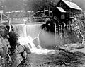
Crystal mill (foreground) and town (behind), 1890s
-
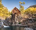
Crystal mill, 2012
-
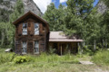
Cabin in Crystal, 2015
-
The Crystal Mill, among the Elk Mountains in 2016. Crystal, CO

.jpg)

