Current River (Ozarks) facts for kids
Quick facts for kids Current |
|
|---|---|

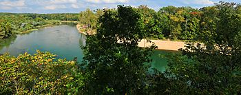
Current River near Doniphan
|
|

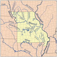
Map of major Missouri Rivers
|
|
| Country | United States |
| State | Missouri, Arkansas |
| Region | Ozark Plateau, Mississippi Alluvial Plain |
| Cities | Van Buren, Doniphan, Missouri |
| Physical characteristics | |
| Main source | Pigeon Creek Montauk Spring Montauk State Park, Dent County, Ozark Plateau, Missouri 935 ft (285 m) 37°27′36″N 91°41′00″W / 37.46000°N 91.68333°W |
| River mouth | Black River Pocahontas, Arkansas, Randolph County, Mississippi Alluvial Plain, Arkansas 243 ft (74 m) 36°15′11″N 90°54′45″W / 36.25306°N 90.91250°W |
| Length | 184 mi (296 km) |
| Basin features | |
| Basin size | 2,641 sq mi (6,840 km2) |
| Tributaries |
|
The Current River is a beautiful river that starts in the Ozark Mountains of Missouri. It flows southeast into northeastern Arkansas. There, it joins the Black River. The Black River then flows into the White River, which eventually reaches the mighty Mississippi River.
The Current River is about 184 miles (296 km) long. It drains an area of about 2,641 square miles (6,840 km2) of land. Most of this land is in Missouri, with a smaller part in Arkansas. The river starts high up, nearly 900 feet (270 m) above sea level. By the time it reaches its end, it's about 280 feet (85 m) above sea level.
The land around the river is mostly rural. It has many caves and springs, which is called karst topography. The rocks under the ground are mainly dolomite and sandstone. In 1964, a big part of the river, over 134 miles (216 km), was protected. It became the Ozark National Scenic Riverways. This was the first national park in America created to protect a river system.
Where the Current River Begins and Its Main Branches
The Current River starts in Montauk State Park. This park is in the southwestern part of Dent County, Missouri. The river's beginning is formed by two water sources. These are Pigeon Creek and Montauk Spring. Montauk Spring provides most of the steady water flow. This makes it a great spot for trout fishing.
After leaving Montauk State Park, the river enters the Ozark National Scenic Riverways. The upper parts of the river flow quickly. They have many small rapids called riffles. These are broken up by deep, clear pools. Further downstream, the riffles are still there but are spaced out more.
The river banks are lined with hardwood trees and rocky ledges. You can also see caves, springs, and tall dolomite cliffs. Welch Spring, a very large spring, joins the river about 14 miles (23 km) downstream. It almost doubles the river's water flow! Other important springs that add water include Cave Spring, Pulltite Spring, and Round Spring.
About 52 miles (84 km) from its start, the Current River gets its biggest branch. This branch is called the Jacks Fork. It joins the Current River from the west near the town of Eminence. Another very large spring, Blue Spring, flows into the river. This happens about 9 miles (14 km) downstream from where the Jacks Fork joins.
The Current River is about 86 miles (138 km) long when it passes by Van Buren. It also goes under U.S. Route 60 there. A few miles south of Van Buren, the river gets its second biggest branch. This is Big Spring. It is the largest spring in the Ozarks. It's also one of the biggest single spring outlets known in the world. Big Spring adds nearly 470 cubic feet (13 m3) of water per second to the river.
From Big Spring, the river continues flowing southeast. It leaves the Ozark National Scenic Riverways about 105 miles (169 km) from its start. The river then flows through Mark Twain National Forest. It reaches Doniphan, Missouri and passes under U.S. Route 160. From here, the river slows down as it leaves the Ozark Highlands. It continues its slower path into Arkansas. There, it receives the Little Black River from the northeast. Finally, it joins the Black River near Pocahontas, Arkansas.
Fun Things to Do on the Current River
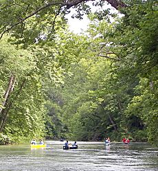
The Current River is a great place for outdoor activities. Many people enjoy canoeing, fishing, horseback riding, and camping here. The river is usually calm and easy to navigate. Most of its rapids are considered Class 1, which means they are gentle. There are a couple of Class 2 rapids, which are a bit more exciting but still safe for most people.
Some cool places to visit along the river include:
- Montauk State Park, which is known for trout fishing.
- Welch Spring and an old hospital nearby.
- Aker's Ferry.
- Cave Spring.
- Devil's Well.
- Deer Leap.
- Rock House Cave.
- Pulltite Spring.
- Round Spring.
- The Jacks Fork tributary.
- Blue Spring.
- Rocky Falls, which is on a small stream that flows into the Current River.
- And of course, Big Spring, one of the largest springs in the world!


