
Cusseta, Georgia facts for kids
Quick facts for kids
Cusseta
|
||
|---|---|---|
|
Consolidated city-county
|
||
| Cusseta, Georgia | ||
.JPG)
Cusseta in 2012
|
||
|
||

Location of pre-consolidation boundary in Chattahoochee County and the state of Georgia
|
||
| Country | United States | |
| State | Georgia | |
| County | Chattahoochee | |
| Seat | Cusseta | |
| Government | ||
| • Type | City-County Consolidation | |
| Area | ||
| • Total | 251.16 sq mi (650.50 km2) | |
| • Land | 248.74 sq mi (644.23 km2) | |
| • Water | 2.42 sq mi (6.28 km2) | |
| Elevation | 531 ft (162 m) | |
| Population
(2020)
|
||
| • Total | 9,565 | |
| • Density | 38.45/sq mi (14.85/km2) | |
| Time zone | UTC-5 (Eastern (EST)) | |
| • Summer (DST) | UTC-4 (EDT) | |
| ZIP code |
31805
|
|
| Area code(s) | 706 | |
| FIPS code | 13-21016 | |

Cusseta is a city in Chattahoochee County, Georgia, in the United States. It is part of the larger Columbus metropolitan area. In 2020, about 9,565 people lived there.
Cusseta is the county seat of Chattahoochee County. This means it's where the main government offices for the county are located. The city and county governments have joined together. Even so, Cusseta is still a separate town within the county.
Contents
History of Cusseta
How Cusseta Was Formed
Chattahoochee County was created on February 13, 1854. It was made from parts of Muscogee and Marion counties. The county was named after the Chattahoochee River, which forms its western border.
Five people were chosen to pick a spot for the county seat. They named it Cusseta. This name was chosen to remember an old Creek Indian town that used to be nearby.
Early Buildings and City Status
The first courthouse building is now kept at a tourist place called Westville in Columbus, Georgia.
Cusseta officially became a city on December 22, 1855. It is still the only official city in Chattahoochee County.
Tall Structures and Government Changes
For a short time, Cusseta was proud to have the world's tallest human-made structure. This was the WTVM/WRBL-TV & WVRK-FM Tower, a tall TV and radio tower built in 1962. It was about a mile from the city. However, just one year later, an even taller tower was built in North Dakota.
In 2003, the city and county decided to combine their governments. This formed a single Cusseta-Chattahoochee County government.
Geography of Cusseta
Cusseta is located at 32°18′20″N 84°46′37″W. The city is southeast of Columbus, Georgia. Major roads like U.S. Route 280, Georgia State Route 520, and U.S. Route 27 pass through or near it.
These highways connect Cusseta to other cities. For example, U.S. Route 280 and Georgia 520 go south and east to Americus and Albany. Other state routes also run through Cusseta.
The United States Census Bureau says the city covers about 1.5 square miles (3.9 km²). Most of this area is land. A part of Fort Moore (which used to be called Fort Benning) is also within the city limits.
Population Information
| Historical population | |||
|---|---|---|---|
| Census | Pop. | %± | |
| 1870 | 216 | — | |
| 1880 | 166 | −23.1% | |
| 1890 | 241 | 45.2% | |
| 1900 | 301 | 24.9% | |
| 1910 | 341 | 13.3% | |
| 1920 | 276 | −19.1% | |
| 1930 | 343 | 24.3% | |
| 1940 | 357 | 4.1% | |
| 1950 | 571 | 59.9% | |
| 1960 | 768 | 34.5% | |
| 1970 | 1,251 | 62.9% | |
| 1980 | 1,218 | −2.6% | |
| 1990 | 1,107 | −9.1% | |
| 2000 | 1,196 | 8.0% | |
| 2010 | 11,267 | 842.1% | |
| 2020 | 9,565 | −15.1% | |
| U.S. Decennial Census | |||
In 2000, there were 1,196 people living in Cusseta. By the 2020 census, the population was 9,565. This was a decrease from 11,267 people in 2010.
Education
Chattahoochee County School District
The Chattahoochee County School District serves students from pre-school all the way to twelfth grade. The district has one elementary school, one middle school, and one high school. There are 85 full-time teachers and over 1,000 students in the district.
- Chattahoochee County Education Center
- Chattahoochee County Middle School
- Chattahoochee County High School
Gallery
-
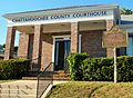
The Chattahoochee County Courthouse is located in Cusseta, the county seat.
-
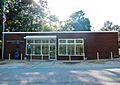
Cusseta Post Office (ZIP code: 31805)
-
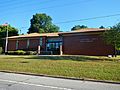
Chattahoochee County Public Library
-
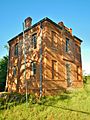
This two-story jail was built in Cusseta in 1902. It was used until 1975. It is now on the National Register of Historic Places.
-
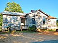
The Cusseta Industrial High School is a Rosenwald School. It was built between 1929 and 1930. It is also on the National Register of Historic Places.
-
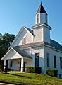
Cusseta First Baptist Church is the oldest church in Cusseta. It was started in 1839.

.JPG)
.JPG)
.JPG)
.JPG)
.JPG)
See also
 In Spanish: Cusseta (Georgia) para niños
