Dangerous Reef facts for kids

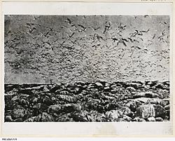
Dangerous Reef, near Pt. Lincoln, a bird colony and seal habitat. Circa 1932.
(State Library of South Australia PRG PRG-458-1-1-9) |
|
| Geography | |
|---|---|
| Coordinates | 34°49′03″S 136°13′03″E / 34.81744479°S 136.21747697°E |
| Archipelago | Sir Joseph Banks Group |
| Adjacent bodies of water | Spencer Gulf |
| Area | 12 ha (30 acres) |
| Highest elevation | 3 m (10 ft) |
| Administration | |
|
Australia
|
|
| Demographics | |
| Population | 0 |
| Coordinates | |
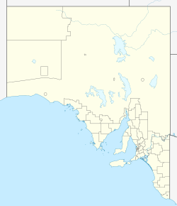
Dangerous Reef is a special island and reef system in Spencer Gulf, South Australia. It is about 32.5 kilometers east-southeast of Port Lincoln. This place is famous for its Australian sea lions, which have a breeding colony here.
The waters around Dangerous Reef are also well-known for great white sharks. People used to come here for fishing and shark cage diving. This reef was even used to film parts of famous movies like Blue Water White Death and Jaws. Dangerous Reef has been a protected area since 1900. It is now part of the Sir Joseph Banks Group Conservation Park.
Contents
What is Dangerous Reef?
Dangerous Reef is located in Spencer Gulf. It is about 32.5 kilometers from Port Lincoln. It is also about 17.5 kilometers east of the nearest mainland on the Eyre Peninsula.
Some people call it a "reef," while others call it an "island." It is part of the Sir Joseph Banks Group of islands. The reef is made up of a chain of four large rocks. The tallest rock is about 3 meters high. Other rocks are barely above the water at low tide.
At high tide, the dry land area is about 12 hectares. At low tide, it grows to about 100 acres (40 hectares). You need special permission to visit the reef. You can get there by boat or helicopter.
How was Dangerous Reef formed?
Dangerous Reef was formed about 8,400 years ago. This happened when sea levels rose at the start of the Holocene period.
The reef is made of very old granite rock. This rock was formed between 1.6 and 1.8 billion years ago. In 1982, it was noted that the reef had no soil. Any soil came from sea lion and seabird waste. The reef system stretches about 1.4 kilometers to the west. It also goes about 4.6 kilometers to the south-east. The south-eastern end often has very strong waves.
Animals and Plants of Dangerous Reef
What plants grow there?
In 1982, only the largest rock had plants. There were two types of plants found. These were Mueller's Saltbush and Leafy Peppercress.
What animals live there?
Dangerous Reef is home to many animals. In 1904, many Australian sea lions lived there. Photos from 1907 show sea lions and cormorants on the reef. Early reports also mentioned many cormorants and terns. Pacific gulls were seen eating cormorant eggs.
In the 1930s, the reef had many birds and seals. There were lots of Australian sea lions. Large male sea lions had their families around them. Younger males stayed a safe distance away. The air was filled with their barking sounds.
In 1982, the reef was a breeding ground for several birds. These included black-faced cormorants, silver gulls, and Pacific gulls. By 1994, the Australian sea lion breeding colony was the second largest of its kind.
History of Dangerous Reef
Who discovered Dangerous Reef?
The British explorer, Matthew Flinders, discovered Dangerous Reef. He named it on March 19, 1802. Flinders often wrote notes about dangers on his maps. These notes then became the names of places. This is how Dangerous Reef got its name.
Capturing animals from the reef
In the late 1800s, people tried to catch animals from Dangerous Reef. They wanted them for zoos. They caught seal pups and terns. Seals were always a common sight on the reef. They were said to be "plentiful" in the 1930s.
What about guano mining?
Before 1919, people mined guano (bird droppings) from Dangerous Reef. This was done with a special permit. However, this activity caused problems. It disturbed the seabirds that lived and bred there.
A navigation aid has been on the largest rock since 1911. This helps boats find their way safely.
Great white sharks and movies
The waters around Dangerous Reef are famous for great white sharks. It was a popular spot for fishing for sharks. This continued until 1997. That year, great white sharks became a protected species in Australia. Sometimes, dolphins were used as bait. One shark caught in 1907 had a whole seal in its stomach. Famous fishermen like Jack Davey and Zane Grey visited these waters.
In 1969, parts of the shark documentary Blue Water White Death were filmed here. In 1974, live shark footage for the movie Jaws was filmed at Dangerous Reef. This was done by Ron Taylor. Another film, Great White of Dangerous Reef, was made in the late 1980s. In this film, sharks were fed from a shark cage.
From the 1970s to 2002, tourists could go shark cage diving here. They could watch sharks safely from inside a cage. Now, shark cage diving tours usually go to the Neptune Islands. These tours leave from Port Lincoln.
Why is Dangerous Reef protected?
Dangerous Reef first became a protected area in 1909. It was called a bird protection district. In 1933, it was also announced that seals there were protected.
Since 1989, it has been part of the Sir Joseph Banks Group Conservation Park. This park also includes the waters up to 2 kilometers from the island's shore. This helps manage shark cage diving activities. Since 2012, the waters around the island are also a sanctuary zone. This is part of the Sir Joseph Banks Group Marine Park.
 | Janet Taylor Pickett |
 | Synthia Saint James |
 | Howardena Pindell |
 | Faith Ringgold |


