
Dartmoor crosses facts for kids

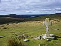
An old cross near Crazywell Pool on southern Dartmoor
|
|
| Location | Devon, England, United Kingdom |
|---|---|
| Coordinates | 50°34′N 4°0′W / 50.567°N 4.000°W |
The Dartmoor crosses are special stone crosses found in Dartmoor National Park in the middle of Devon, England. Many of these crosses were put there a long time ago to help people find their way. Dartmoor can be a wild place with bad weather, so these crosses were like ancient signposts!
Some crosses marked old paths used by monks between their abbeys during the Middle Ages. Other crosses were put up to remember people, for prayer, or as markers for towns, markets, churchyards, and land boundaries. These crosses were built over many years. Some are almost 1,000 years old, while others were made just about 100 years ago.
In 2005, the Dartmoor National Park Authority started a project to protect these old granite crosses. They began putting tiny microchips inside the most important ones. This helps stop people from stealing them and makes it easier to find them if they do go missing.
Contents
A Dartmoor Legend

There's an old story about how some of the first crosses came to be. The legend says there were four monks who didn't like their abbot's strict rules about living simply. One day, when the abbot went to Italy, the four brothers decided to have a party. But they needed money for it. So, they decided to get money in a bad way, hurting a traveler.
That same evening, the brothers were called to the nearby moor. It was covered in snow and ice. When they arrived, they realized the messenger who called them was the ghost of the traveler they had harmed! The ghost put them in a trance, and they wandered into a bog. They fell through the ice and were pulled into the thick mud.
The abbot didn't know about the traveler. He thought the monks had run away because they felt guilty when they saw him coming home. So, he ordered crosses to be put up. These crosses were meant to mark the paths between monasteries. This way, future monks wouldn't get lost.
Famous Crosses of Dartmoor
Bennett's Cross

This cross stands beside the road that goes from Moretonhampstead to Two Bridges. It's about 900 meters (about half a mile) north-west of the Warren House Inn. It was probably placed here for two reasons. First, it was an early marker for this route, long before the road was built. Second, it marked the border between the areas of Chagford and North Bovey.
We don't know much about the early history of this cross. But its simple shape suggests it's very old. Later, it was used to mark the boundary of Headland Warren. The letters "WB" carved on one side mean "Warren Bounds." It also marked the edge of the Vitifer Mine mining area. This cross likely survived because it was used as a boundary marker. Two similar crosses further along the road were removed in the 1800s.
The reason for its name is not fully known. In 1902, William Crossing, a famous writer about Dartmoor, said it was mentioned in a document from 1702. That document showed it was already well-known back then. Some people think it might have been put up by monks from a Benedictine Order. "Bennet" was a common way to say "Benedict." Another idea is that it's named after William Bennet. He was a miner who attended a special meeting called a Stannary Parliament in the early 1500s.
Cadover Cross
.JPG)
Cadover Cross is on Wigford Down. It's about 250 meters (a quarter of a mile) north-west of Cadover Bridge. This is on a small road between Plympton and Yelverton. Two important paths from the 1100s used the river crossing here. One went from Tavistock to Plympton Priory. The other went to Ivybridge through Cornwood. So, it's very likely the cross was there even then. The first written record of it as a boundary marker is from 1381.
The top part of the cross was found by soldiers in 1873. The local vicar asked them to put it back where they found it. By 1901, it had fallen again. It stayed down until 1915. Then, Hugh Breton, the vicar of Sheepstor, arranged for it to be put back up with a new base. While looking for a good spot, they dug a hole and luckily found the original stone base! They raised it to ground level and used it again.
Writers from the early 1900s said there were carved crosses on its sides. But today, they are very hard to see.
Crazywell Cross
Crazywell Cross is an old cross near Crazywell Pool in southern Dartmoor. Its arms get wider as they move away from the center, like a special cross shape called a cross pattée. It was probably used to mark the "Monks' Path." This path went from Buckfast Abbey to Tavistock Abbey.
The top part of the cross was found near the north-east side of the pool by William Crossing. He thought its original spot was closer to the path. So, it was given a new base and set up there. In 1952, people reported that the cross was damaged again. It was then repaired, and its base was made more secure.
Many old stories and beliefs are connected to the nearby area. People used to say that Crazywell Pool had no bottom. They also believed the pool's water could predict which monk would die next. There was also a legend about a witch who lived there. She was said to haunt the place and give people bad advice. One story says she advised Piers Gaveston, a friend of King Edward II, to return to the king's court. He had been sent away to Ireland. The witch told him, "his humbled head shall soon be high." But instead, he was caught by the king's enemies and executed.
Goldsmith's Cross

Goldsmith's Cross is in the Fox Tor Mire area. It's located between Childe's Tomb and Nun's Cross, right on the Monks' Path. It was named after Lieutenant M. Lennon Goldsmith. He found the base, top, and lower part of the cross in 1903. This made it the last major cross discovery on the moor.
He told William Crossing about his find. Crossing had just published his detailed book about Dartmoor's crosses. At first, Crossing didn't believe it existed. So, Goldsmith put it back together with the help of four sailors from his ship. He then gave the details to Crossing, who agreed and added it to the 1910 edition of his Guide to Dartmoor. The cross is short and thick because the upper part of its main shaft was never found.
Horn's Cross

Horn's Cross is on the lower part of Holne Ridge. It's east of the O Brook and about 0.5 miles (0.8 km) south of Combestone Tor. It stands where the Monks' Path meets another track. This other track was used by moorland farmers and went from Hexworthy to South Brent. It is now the first moorland cross on the eastern end of the Monks' Path. However, people think another cross used to be closer to the edge of the moor.
In 1887, William Crossing wrote that the cross was badly broken. Only the base stone and the top part were left. The top part included a small piece of the main shaft and only one complete arm. The cross has since been fixed with a new shaft. But one of its arms is still broken. You can clearly see the iron pieces holding the top to the shaft.
Near the cross, along the top of the ridge, are several low Bronze Age burial mounds called cairns. There are also remains of stone rows that were built with them. The cairn closest to the cross (60 meters or about 200 feet to the west) was dug up by Robert Burnard in 1905. He said its central pit had "a lot of charcoal and burnt bones, but no other relics."
Mount Misery Cross

Like Crazywell Cross, Mount Misery Cross also marked the Monks' Path. This path connected Buckfast Abbey and Tavistock Abbey. The name "Misery" was given to this spot because of the very harsh weather. This part of Fox Tor Newtake is very open and windy.
When William Crossing first saw this cross, it was lying on the ground. In 1879, it was standing. But by 1881, it was down again. Crossing helped put it back up in 1885, and it has been standing ever since.
The famous Fox Tor mire, a boggy area near the cross, inspired the "Grimpen Mire." This was a dangerous bog described by Sir Arthur Conan Doyle in his famous book, The Hound of the Baskervilles.
Nun's or Siward's Cross

This is the largest and oldest cross recorded on Dartmoor. It was mentioned in a document from 1240 that described the boundaries of the Forest of Dartmoor. It was historically known as Siward's Cross. This name likely comes from Siward, Earl of Northumbria. He lived around the time of Edward the Confessor. Siward was the Lord of the Manor of Tavei (which is probably Mary Tavy today). He also witnessed the document that created Exeter Cathedral in 1050.
The reason for its other name, Nun's Cross, is not known. It was first recorded as "Nannecross" in 1699. William Crossing thought it might come from the old Cornu-Celtic word "nans" or "nant," which means valley or ravine.
The cross was probably put up during King Edward the Confessor's rule (1042–1066). It stands where two main paths across the moor meet: The Monks’ Path and the Abbots’ Way. Both of these paths connected Buckfast Abbey to Tavistock Abbey and Buckland Abbey. The cross was knocked down in 1846, and its main shaft broke. It was fixed in 1848 by Sir Ralph Lopes.
Both sides of the cross have carvings that are hard to read because of the weather. People have wondered about these carvings since the 1800s. One popular idea today is that the western side says BOC LAND. This would mark the edge of the land owned by Buckland Abbey. However, on a map from the 1500s that shows the 1240 boundary, it is written as ROOLANDE. This side also has a cross carved above the letters. The eastern side might say SIWARD or SYWARD.
Spurrell's Cross

Spurrell's Cross is on Ugborough Moor, about three miles (4.8 km) north-east of Ivybridge. This cross is at a crossroads of two old tracks. One was an east-west path between Exeter and Plymouth. The other was the north-south Blackwood path, once used by people who cut peat (a type of fuel).
This cross is special on Dartmoor because it has "spurred limbs." This style was popular in the 1300s. It is badly damaged, and only the top part (missing one arm) is original. A well-preserved cross with the same design, but made of sandstone, is in the church porch in Ermington. That village is about four miles (6.4 km) to the south. Spurrell's Cross was fixed with a new shaft by the Dartmoor Preservation Association in 1931. But it was later knocked down again. The same group put it back up in 1954.
Ter Hill crosses

There used to be two crosses on Ter Hill: a southwest one and a northeast one. The southwest cross was badly damaged. It was too fragile to stay in its original spot. So, it was moved to the Jack Wigmore Memorial Garden in Princetown. A copy of the southwest cross was put up on Ter Hill in 1994.
The northeast cross was moved from its original place in the 1600s. A man named Mr. Coaker from Sherberton used it in his courtyard. Eventually, the cross was brought back to its original spot and put up again in 1885.
Other Crosses
There are 132 known crosses inside the Dartmoor National Park area. Here is a list of a few more of them:
- Childe's Tomb
- Fingle Bridge Cross
- Harton Cross
- Hexworthy Cross
- Hobajohn's Cross
- Huntingdon Cross
- Maggie Cross
- Petre's Cross
- Southcott Cross
- Sampford Spiney Cross
- Shaugh Prior crosses
- Sherwell Cross
- Week Down Cross
- Widecombe crosses
- Widgery Cross
Lost Crosses
A document from 1280, written by Amicia, Countess of Devon, mentions Siward's Cross (which is listed above). It also mentions five other crosses that are now lost. Their names were Copriscrosse, Wolewille, Maynstoncross, Smalacumbacrosse, and Yanedonecross.
Images for kids
-
Ancient cross close to Crazywell Pool on southern Dartmoor
See also
 In Spanish: Cruces de Dartmoor para niños
