Shamong Township, New Jersey facts for kids
Quick facts for kids
Shamong Township, New Jersey
|
|
|---|---|
|
Township
|
|

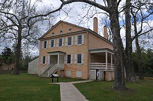
Samuel Richards Mansion in Atsion, a settlement within Shamong Township
|
|

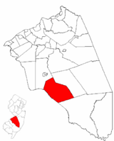
Shamong Township highlighted in Burlington County. Inset map: Burlington County highlighted in the State of New Jersey.
|
|

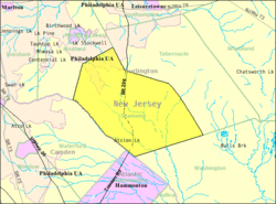
Census Bureau map of Shamong Township, New Jersey
|
|
| Country | |
| State | |
| County | |
| Incorporated | February 19, 1852 |
| Government | |
| • Type | Township |
| • Body | Township Committee |
| Area | |
| • Total | 45.01 sq mi (116.58 km2) |
| • Land | 44.45 sq mi (115.14 km2) |
| • Water | 0.56 sq mi (1.44 km2) 1.24% |
| Area rank | 41st of 565 in state 6th of 40 in county |
| Elevation | 56 ft (17 m) |
| Population
(2020)
|
|
| • Total | 6,460 |
| • Estimate
(2023)
|
6,503 |
| • Rank | 329th of 565 in state 25th of 40 in county |
| • Density | 145.3/sq mi (56.1/km2) |
| • Density rank | 523rd of 565 in state 35th of 40 in county |
| Time zone | UTC−05:00 (Eastern (EST)) |
| • Summer (DST) | UTC−04:00 (Eastern (EDT)) |
| ZIP Code |
08088
|
| Area code(s) | 609 exchanges: 268, 801, 859 |
| FIPS code | 3400566810 |
| GNIS feature ID | 0882084 |
Shamong Township is a community in Burlington County, New Jersey. It's called a "township" and is located in the southern part of the state. In 2020, about 6,460 people lived here. This number was a little less than in 2010.
Shamong Township became an official township on February 19, 1852. It was formed from parts of other nearby townships like Medford and Southampton. Later, some of its land was used to create Woodland Township and Tabernacle Township.
The name "Shamong" comes from Native American words. It means "place of the big horn." In 2008, New Jersey Monthly magazine said Shamong Township was the 6th best place to live in New Jersey!
Contents
History of Shamong Township
Long ago, the Lenape Native Americans lived in this area. They spoke a language called Unami. Their land stretched from New York to New Jersey, Pennsylvania, and Delaware.
By the mid-1700s, English settlers moved into the area. The local Lenape people were moved to a special area called the Brotherton Indian Reservation. This reservation was near what is now Indian Mills.
After the American Revolutionary War, more settlers came. The Brotherton Indians moved to New York. They joined another group of Christian Native Americans called the Stockbridge–Munsee Community. Later, in the 1820s and 1830s, these groups were forced to move again. This was part of a U.S. policy to move Native Americans west of the Mississippi River.
Today, the Stockbridge–Munsee Community is a recognized tribe. They have a reservation in Shawano County, Wisconsin. In 1992, people in Shamong Township voted on changing the township's name to Indian Mills. This vote was not legally binding.
Geography and Nature in Shamong
Shamong Township covers about 45 square miles (116.58 square kilometers). Most of this area is land, with a small part being water. Some smaller communities and places within the township include Atsion and Indian Mills.
Shamong shares borders with several other townships. These include Medford, Tabernacle, and Washington townships in Burlington County. It also borders Hammonton in Atlantic County and Waterford Township in Camden County.
A big part of Shamong Township is in the New Jersey Pinelands National Reserve. This is a special protected natural area. It covers a huge 1.1 million acres and is known for its unique plants and animals. It was made a National Reserve by Congress in 1978.
Population and People
| Historical population | |||
|---|---|---|---|
| Census | Pop. | %± | |
| 1860 | 1,008 | — | |
| 1870 | 1,149 | * | 14.0% |
| 1880 | 1,097 | −4.5% | |
| 1890 | 958 | −12.7% | |
| 1900 | 910 | −5.0% | |
| 1910 | 483 | * | −46.9% |
| 1920 | 414 | −14.3% | |
| 1930 | 475 | 14.7% | |
| 1940 | 505 | 6.3% | |
| 1950 | 712 | 41.0% | |
| 1960 | 774 | 8.7% | |
| 1970 | 1,318 | 70.3% | |
| 1980 | 4,537 | 244.2% | |
| 1990 | 5,765 | 27.1% | |
| 2000 | 6,462 | 12.1% | |
| 2010 | 6,490 | 0.4% | |
| 2020 | 6,460 | −0.5% | |
| 2023 (est.) | 6,503 | 0.2% | |
| Population sources: 1860–2000 1860–1920 1860–1870 1870 1880–1890 1890–1910 1910–1930 1940–2000 2000 2010 2020 * = Lost territory in previous decade. |
|||
In 2010, there were 6,490 people living in Shamong Township. There were 2,168 households, which are groups of people living together. Most of the people (about 96.86%) were White. There were also smaller numbers of Black, Native American, and Asian residents. About 2.30% of the population was Hispanic or Latino.
The average household had almost 3 people. About 40.2% of households had children under 18. Many households (71.7%) were married couples.
The median age of people in Shamong was about 41.9 years old. This means half the people were younger than 41.9 and half were older. About 26.8% of the population was under 18 years old.
Education in Shamong
Students in Shamong Township go to public schools run by the Shamong Township School District. This district teaches students from kindergarten through eighth grade. There are two schools in the district.
Indian Mills Elementary School teaches students from Pre-Kindergarten to 4th grade. Indian Mills Memorial Middle School teaches students from 5th to 8th grade.
For high school, students from Shamong Township attend Seneca High School. This school is located in Tabernacle Township. It also serves students from Southampton, Tabernacle, and Woodland townships. Seneca High School is part of the Lenape Regional High School District.
Students in Burlington County can also attend the Burlington County Institute of Technology. This school offers special vocational and technical training. It has campuses in Medford and Westampton Township.
Transportation in Shamong
Shamong Township has many miles of roads. Most of these roads are taken care of by the township itself. Some are maintained by Burlington County, and a few by the New Jersey Department of Transportation.
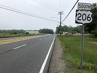
The most important highway that goes through Shamong Township is U.S. Route 206. Other important roads include County Route 534 and County Route 541.
Local Wineries
Shamong Township is home to a winery:
Famous People from Shamong
Many interesting people have lived in or are connected to Shamong Township:
- Daria Berenato (born 1993): A professional wrestler known as Sonya Deville in WWE.
- Kacey Carrig (born 1992): A well-known model.
- Kevin Comer (born 1992): A professional baseball pitcher for the Detroit Tigers team.
- John J. Gardner (1845–1921): A former Mayor of Atlantic City, New Jersey and a U.S. Representative.
- Keith Jones (born 1968): A former professional ice hockey player for the Philadelphia Flyers.
- Juliet Richardson (born 1980): A singer known for her album Random Order.
- William Still (1821–1902): An important person who worked to end slavery.
- Joe Vento (1939–2011): The owner of the famous South Philadelphia cheesesteak shop, Geno's Steaks.
See also
 In Spanish: Municipio de Shamong para niños
 | Lonnie Johnson |
 | Granville Woods |
 | Lewis Howard Latimer |
 | James West |


