Des Moines Rapids facts for kids
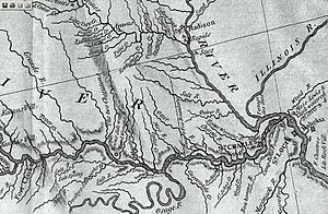
The Des Moines Rapids were a challenging part of the Mississippi River. They were located between Nauvoo, Illinois and Keokuk, Iowa-Hamilton, Illinois. These rapids were one of two main areas on the Mississippi where the river flowed very fast over rocks. This made it hard for Steamboats to travel easily in the early 1800s.
The rapids were just above where the Des Moines River joins the Mississippi. They even played a role in a border dispute called the Honey War in the 1830s. This conflict was between the states of Missouri and Iowa.


Contents
What Were the Des Moines Rapids?
The Mississippi River naturally got much wider at the Des Moines Rapids. It spread from about 760 meters (2,500 feet) to 1,370 meters (4,500 feet) wide near Nauvoo. Over a distance of about 18 kilometers (11 miles), the river dropped 6.7 meters (22 feet). This drop happened over shallow limestone rocks.
Records show that the average depth of the water through the rapids was only about 0.73 meters (2.4 feet). In many spots, it was even shallower. This made it very difficult for large boats to pass.
People realized early on that the rapids were a problem for river travel. So, they started trying to make the river easier to navigate.
Blasting a Channel
In 1837, the U.S. Army Corps of Engineers began working on the rapids. A team led by Robert E. Lee used explosives to blast a channel through the rocks. This helped some, but it wasn't a complete solution.
Building a Canal
Later, in 1877, a canal was built around the rapids. A canal is like a man-made river that allows boats to bypass difficult sections. Today, this canal is gone. It was replaced by Lock and Dam No. 19, which helps boats travel smoothly through this area.
Trading Posts and Forts
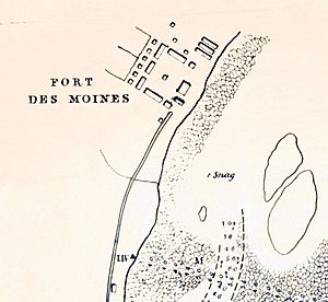
Starting in 1804, the United States government set up trading posts for Native American tribes. These posts were part of a system to trade goods. Several forts were built near these trading posts, including Fort Johnson and Fort Madison.
During the War of 1812, these forts were burned down. After the war, a new fort was built called Fort Edwards. It was commanded by Zachary Taylor, who later became a U.S. President.
The Honey War and the State Border
The Des Moines Rapids played a big part in a border dispute known as the Honey War. This conflict happened between Missouri and Iowa in the 1830s.
The Sullivan Line
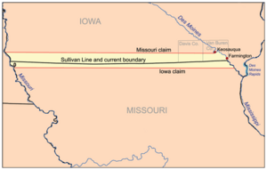
In 1816, a government surveyor named John C. Sullivan drew a line. This line went about 160 kilometers (100 miles) north from where the Kansas River meets the Missouri River. Then it turned east to the Des Moines River. This line was supposed to match the location of the rapids.
However, when Missouri became a state in 1820, its constitution described the border differently. It said the border was "the parallel of latitude which passes through the rapids of the River Des Moines." This was a mistake, as the actual rapids were on the Mississippi, not the Des Moines River.
Land Disputes
Even with this mistake, Missouri didn't try to fix it. In 1824, the Iowa, Sauk, and Fox tribes gave up land "in Missouri" along this line. This created an area known as the Half-Breed Tract.
As work began to make the rapids navigable in the late 1830s, Iowa was also preparing to become a state. Missouri then became interested in controlling the land on the west side of the rapids. But Missouri's constitution clearly stated the Des Moines River was the border.
So, Missouri claimed that there were no rapids where the Sullivan line crossed the Des Moines River. They did a new survey, saying the rapids were about 15 kilometers (9.5 miles) north, near Keosauqua, Iowa. Missouri then tried to collect taxes in this area. This led to the "Honey War," where Iowa resisted Missouri's efforts. It was called the Honey War because some Missouri officials tried to take beehives from Iowa residents as a form of tax collection. No one was seriously hurt in this "war."
The Supreme Court Decision
The dispute eventually went to the highest court in the United States, the Supreme Court. In 1849, the Supreme Court decided in State of Missouri v. State of Iowa that Iowa's southern border was at the foot of the rapids near modern-day Keokuk. However, the court accepted the original Sullivan Line for the rest of the border, about 32 kilometers (20 miles) west.
Other Major Rapids
The Des Moines Rapids were not the only major rapids on the Mississippi River. The other significant rapids that blocked river traffic were the Rock Island Rapids.
 | Mary Eliza Mahoney |
 | Susie King Taylor |
 | Ida Gray |
 | Eliza Ann Grier |

