
Dogpatch, San Francisco facts for kids
Quick facts for kids
Dogpatch
|
|
|---|---|
 |
|

Dogpatch
Location in San Francisco
|
|
| Country | |
| State | |
| City-county | San Francisco |
| Area | |
| • Total | 0.221 sq mi (0.57 km2) |
| • Land | 0.221 sq mi (0.57 km2) |
| Population
(2008)
|
|
| • Total | 828 |
| • Density | 3,751/sq mi (1,448/km2) |
| Time zone | UTC−8 (Pacific Time Zone) |
| • Summer (DST) | UTC−7 (PDT) |
| ZIP Code |
94107
|
| Area codes | 415/628 |
Dogpatch is a unique neighborhood in San Francisco, California. It's a mix of old factories and homes. For a long time, it was a place where working-class families lived. But since the 1990s, it has changed a lot. More people with higher incomes have moved in. Now, it's similar to its neighbor, Potrero Hill, with many working professionals.
Dogpatch was once part of a larger area called Potrero Nuevo. Its story is closely connected to Potrero Hill. Dogpatch has its own groups for residents and businesses. But it often works with Potrero Hill on bigger community issues.
Contents
Where is Dogpatch Located?

Dogpatch is on the eastern side of San Francisco. It sits right next to the San Francisco Bay waterfront. To its west is Potrero Hill.
The neighborhood's borders are Mariposa Street to the north. I-280, a major freeway, is to the west. Cesar Chavez Street is to the south, and the waterfront is to the east. Dogpatch has homes, some older factories, and newer, smaller businesses. It also has a growing area for art. In 2002, Dogpatch became an official historic district. This means its unique character and buildings are protected.
What Makes Dogpatch Special?
Dogpatch is mostly flat land with many docks. Many of these docks were built on land that was filled in. It's known for its industrial past, but now it also has many homes. Old warehouses have been turned into modern apartments. Like Potrero Hill, Dogpatch often gets sunny weather in San Francisco.
Getting Around Dogpatch
The Caltrain station at 22nd Street makes Dogpatch popular for people who work south of San Francisco. This station is one of only a few that offer fast "Baby Bullet" express train service.
Third Street is the main street for shops and services in Dogpatch. The T Third Street light rail line runs along this street. This train connects Dogpatch to downtown San Francisco. It also links to new areas like Mission Bay and the UCSF research campus.
Cool Places to See
- Irving M. Scott School: This is the oldest public school building in San Francisco, built in 1895.
- Historic Shipyards at Pier 70: These old shipyards show Dogpatch's past as a center for shipbuilding.
- Esprit Park: A nice grassy park with trees, given to the city by Esprit Corp.
- Restaurants and Breweries: Dogpatch has many places to eat and drink.
- Green Benefit District: Dogpatch and Northwest Potrero Hill created the first "Green Benefit District." This allows residents to help make their neighborhood greener and more beautiful.
The Name "Dogpatch"
Why is it Called Dogpatch?
The name "Dogpatch" was first used before World War II. No one knows for sure how it got its name, but there are a few ideas:
- Some say it was called "Dutchman's Flat" because Dutch immigrants lived there.
- It might be named after the fictional town "Dogpatch" from the old comic strip, Li'l Abner. This comic strip showed a simple, undeveloped place.
- Another idea is that it's named after a type of flower called dogfennel that grows there.
- Some believe it's because packs of dogs used to scavenge for meat scraps from nearby slaughterhouses.
How People Use the Name
Sometimes people say "the Dogpatch" and sometimes just "Dogpatch." Writers and locals use both versions. For example, one writer might say "the Dogpatch neighborhood," while another might just say "Dogpatch."
Dogpatch's Past
The history of Dogpatch and Potrero Hill is closely linked. Both areas were once part of Potrero Nuevo. Factories first came to Dogpatch in the mid-1850s. The first people to live there were mostly European immigrants who worked in these factories. Over time, Dogpatch became more industrial. Many residents moved to Potrero Hill. Dogpatch stayed a working-class area until the mid-1990s. Then, it started to change a lot as new people moved in.
Dogpatch was not badly damaged by the 1906 earthquake and fire. Because of this, and because it wasn't redeveloped for a long time, Dogpatch has some of San Francisco's oldest houses. Some homes date back to the 1860s. Between the 1860s and 1880s, the marshy areas near the bay were filled in. Bridges were built to connect Dogpatch to the main part of the city. Industries like shipbuilding, warehouses, and steel mills grew until after World War II. After the war, these industries started to decline.
Dogpatch went through a quiet period for several decades. This lasted until the 1990s. Then, economic changes led to some new housing. Old industrial buildings were turned into modern apartments. Many of these were designed for artists and designers. Turning old factories into homes has sometimes been a debated topic.
Early Beginnings
For much of its early history, Dogpatch was empty land. Native Americans sometimes used it for hunting. In the late 1700s, Spanish missionaries used the hills to graze cattle. They called this area (Dogpatch and Potrero Hill) Potrero Nuevo. "Potrero" is a Spanish word for "pasture," so "Potrero Nuevo" means "new pasture."
Rancho Potrero de San Francisco
Mexico became independent from Spain in 1821. In 1844, the Mexican Governor of Alta California, Juan Alvarado, gave the land of Rancho Potrero de San Francisco to Francisco and Ramon de Haro. They were 17-year-old twin sons of Don Francisco de Haro, who was the mayor of Yerba Buena (which is now San Francisco).
Sadly, just two years later, the de Haro twins were killed. This happened during a conflict called the Bear Flag Revolt. With their deaths, their father, Don Francisco de Haro, became the owner of the land.
Building Streets in the Gold Rush Era
In 1848, the Mexican–American War ended, and Mexico gave California to the United States. California became a state in 1850. Dr. John Townsend became the second mayor of San Francisco. He had a big impact on Potrero Hill.
The Gold Rush started in 1848, and San Francisco grew very fast. Townsend wanted to develop Potrero Hill for new people coming to California. He talked to de Haro about dividing his land into lots to sell. De Haro agreed, fearing the U.S. government might take his land.
Townsend, with a surveyor named Jasper O'Farrell, planned the streets. They named the north-south streets after American states (like Arkansas and Kansas). The east-west streets were named after California counties (like Mariposa and Alameda). At this time, Potrero Hill was not part of San Francisco. So, they called this area "South San Francisco."
Historians think they hoped naming streets after states and counties would attract people from the eastern U.S. to settle there. Most of the county street names changed by 1895. But a few, like Mariposa and Alameda, still exist today.
By the mid-1800s, Potrero Hill was hard to reach. It was separated by Mission Bay, which was not yet filled in. Few lots were sold. In late 1849, Don Francisco de Haro passed away.
Early Factories and Businesses
After de Haro's death, people started to settle on Potrero Point without permission. The de Haro family tried to keep control, but their ownership was challenged in court. In 1866, the Supreme Court ruled against the de Haro family.
Development finally came in the early 1850s. It wasn't wealthy gold miners, but working-class people. A power plant opened in 1852. Then, a gunpowder factory opened, followed by shipyards, iron factories, and warehouses. More workers moved nearby. In 1856, San Francisco Cordage opened a large rope factory. The opening of the Long Bridge in the 1860s would greatly change Dogpatch.
The Long Bridge (1865 to early 1900s)
In 1862, President Lincoln signed a law to support building the first transcontinental railroad. To prepare for this, San Francisco built the Long Bridge in 1865. This bridge connected downtown San Francisco over Mission Bay to Potrero Hill, Dogpatch, and Bayview. Dogpatch, once considered far away, was now just a mile's walk. The Long Bridge completely changed Potrero Nuevo. It became a central area. The Long Bridge closed in the early 1900s after Mission Bay was filled in. This made Dogpatch an even more desirable place.
European Immigrants Arrive
,_circa_in_1918_(NH_42535).jpg)
By the early 1900s, many European immigrants had settled in Dogpatch. The two earliest neighborhoods were Irish Hill and Dutchman's Flat. Irish Hill, near the factories, was home to many Irish factory workers. It was later removed in 1918.
At this time, over half of Dogpatch's population was Irish immigrants. People from Scotland, Switzerland, Russia, Slovenia, Serbia, and Italy also lived there. Less than 20% of the population was white people born in the U.S.
Freeway and Growth
By the 1930s, Dogpatch was mostly built up. Cars became more affordable, so factory workers could live further away. This meant there wasn't a big need for more housing in Dogpatch until the 1980s. Because of this, many homes from the late 1800s and early 1900s are still standing today.
World War II brought an industrial boom to Dogpatch. Shipyards built navy ships, and the population grew.
In the 1960s, Interstate 280 was built. This freeway cut through Potrero Nuevo. The area east of the freeway started to become known as "Dogpatch."
Dogpatch Today
Dogpatch began to change from its industrial past in the 1990s. More people moved in from nearby neighborhoods like Potrero Hill. The development of Mission Bay, just north of Dogpatch, also helped change the area. Mission Bay became a center for biotechnology and healthcare. The building of Oracle Park in the late 1990s also brought more development. Many new apartment buildings were built near the ballpark.
From 2010 to 2020, Dogpatch's population grew by 200%. In 2013, Dogpatch got its first art museum. The Museum of Craft and Design (MCD) opened on 3rd Street. It brought art from local, national, and international artists to the neighborhood. In 2016, the Minnesota Street Project (MSP) opened. This is a visual arts organization that supports local art events.
Images for kids
-
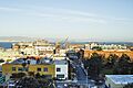
A view of Dogpatch.
