Dorchester County, South Carolina facts for kids
Quick facts for kids
Dorchester County
|
|||||
|---|---|---|---|---|---|

|
|||||
|
|||||

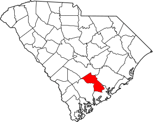
Location within the U.S. state of South Carolina
|
|||||
 South Carolina's location within the U.S. |
|||||
| Country | |||||
| State | |||||
| Founded | February 25, 1897 | ||||
| Named for | Dorchester, Massachusetts | ||||
| Seat | St. George | ||||
| Largest community | North Charleston | ||||
| Area | |||||
| • Total | 571.18 sq mi (1,479.3 km2) | ||||
| • Land | 568.59 sq mi (1,472.6 km2) | ||||
| • Water | 2.59 sq mi (6.7 km2) 0.45% | ||||
| Population
(2020)
|
|||||
| • Total | 161,540 | ||||
| • Estimate
(2023)
|
169,833 | ||||
| • Density | 284.11/sq mi (109.70/km2) | ||||
| Time zone | UTC−5 (Eastern) | ||||
| • Summer (DST) | UTC−4 (EDT) | ||||
| Congressional districts | 1st, 6th | ||||
Dorchester County is a county located in the U.S. state of South Carolina. It is known for its rich history and beautiful natural areas. As of the 2020 census, about 161,540 people lived there.
The county's main town, called its county seat, is St. George. Dorchester County was officially created on February 25, 1897. It is part of the larger Charleston-North Charleston Metropolitan Area. This area is in the Lowcountry region of South Carolina.
Contents
History of Dorchester County
Dorchester County gets its name from its very first settlement. This settlement was started in 1696 by a group of people called Congregationalists. They named the new place "Dorchester" after their previous home in Dorchester, Massachusetts.
Even though the settlement was old, Dorchester was not a separate county until 1897. When it became a county, it was formed from parts of two nearby counties: Colleton County and Berkeley County.
Geography of Dorchester County
Dorchester County covers a total area of about 571 square miles. Most of this area, about 568 square miles, is land. The rest, about 2.59 square miles, is water.
Natural and Historic Places
Dorchester County has several important natural and historic sites. These places are protected for everyone to enjoy.
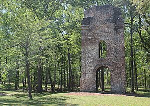
- Colonial Dorchester State Historic Site
- Edisto River Wildlife Management Area
- Givhans Ferry State Park (part)
- Middleton Place
Major Rivers and Swamps
The county is home to several important water bodies. These include rivers and swamps that are part of the local ecosystem.
- Ashley River
- Four Hole Swamp
- Edisto River
Neighboring Counties
Dorchester County shares its borders with several other counties in South Carolina.
- Bamberg County – to the west
- Berkeley County – to the east
- Charleston County – to the southeast
- Colleton County – to the southwest
- Orangeburg County – to the northwest
Main Roads and Transportation
Several major highways run through Dorchester County. These roads help people travel and transport goods.
 I-26
I-26 I-95
I-95 US 15
US 15 US 17
US 17
 US 17 Alt.
- Invalid type: US-Alt-Truck
 US 78
US 78 US 178
 SC 27
SC 27 SC 61
SC 61


 SC 61 Conn.
 SC 165
 SC 453
 SC 642
The county also has an airport.
- Summerville Airport
People of Dorchester County
| Historical population | |||
|---|---|---|---|
| Census | Pop. | %± | |
| 1900 | 16,294 | — | |
| 1910 | 17,891 | 9.8% | |
| 1920 | 19,459 | 8.8% | |
| 1930 | 18,956 | −2.6% | |
| 1940 | 19,928 | 5.1% | |
| 1950 | 22,601 | 13.4% | |
| 1960 | 24,383 | 7.9% | |
| 1970 | 32,276 | 32.4% | |
| 1980 | 58,761 | 82.1% | |
| 1990 | 83,060 | 41.4% | |
| 2000 | 96,413 | 16.1% | |
| 2010 | 136,555 | 41.6% | |
| 2020 | 161,540 | 18.3% | |
| 2023 (est.) | 169,833 | 24.4% | |
| U.S. Decennial Census 1790–1960 1900–1990 1990–2000 2010 2020 |
|||
The population of Dorchester County has grown a lot over the years. In 2020, the county had 161,540 people living there. There were 57,768 households and 41,473 families.
Diversity in Dorchester County
The county is home to a diverse group of people. Here's a look at the different groups reported in the 2020 census:
| Race | Num. | Perc. |
|---|---|---|
| White (non-Hispanic) | 99,145 | 61.37% |
| Black or African American (non-Hispanic) | 38,278 | 23.7% |
| Native American | 886 | 0.55% |
| Asian | 3,286 | 2.03% |
| Pacific Islander | 199 | 0.12% |
| Other/Mixed | 8,885 | 5.5% |
| Hispanic or Latino | 10,861 | 6.72% |
In 2010, the county had 136,555 people. The average household had about 2.68 people. The average family had about 3.11 people. The median age of people in the county was 35.6 years old.
Economy of Dorchester County
The economy of Dorchester County is strong. In 2022, the total value of all goods and services produced, called the GDP, was about $5.3 billion. This shows how much economic activity happens in the county.
The unemployment rate in Dorchester County has been low. Between 2022 and 2023, it stayed between 2.6% and 2.9%. This means most people who want to work can find jobs.
Major Employers
Many large companies and organizations provide jobs in Dorchester County. As of April 2024, some of the biggest employers include:
- Bosch
- Food Lion
- Harris Teeter
- KION Group
- Publix
- The town of Summerville
- Walmart
Education in Dorchester County
Education is important in Dorchester County. The county has two main school districts that serve its students.
- Dorchester School District 2
- Dorchester School District 4
- Districts 1 and 3 joined together to create District 4 in 1987.
Communities in Dorchester County
Dorchester County has several different types of communities. These include cities, towns, and smaller unincorporated areas.
Cities
- North Charleston (This is the largest community. Parts of it are also in Berkeley and Charleston counties.)
Towns
- Harleyville
- Lincolnville (Most of this town is in Charleston County.)
- Reevesville
- Ridgeville
- St. George (This is the county seat.)
- Summerville (Parts of this town are also in Berkeley and Charleston counties.)
Census-Designated Places
These are areas that are like towns but are not officially incorporated.
- Ladson (Parts of Ladson are also in Berkeley County and Charleston County.)
Unincorporated Communities
These are smaller communities that are not part of an official city or town.
- Grover
- Byrds
- Knightsville
Ghost Town
- Dorchester (This is a historic site where a town once stood.)
See also
 In Spanish: Condado de Dorchester (Carolina del Sur) para niños


