Dover, Vermont facts for kids
Quick facts for kids
Dover, Vermont
|
|
|---|---|

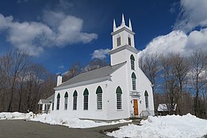
Dover Town Hall
|
|

Dover, Vermont
|
|
| Country | United States |
| State | Vermont |
| County | Windham |
| Communities |
|
| Area | |
| • Total | 35.3 sq mi (91.4 km2) |
| • Land | 35.3 sq mi (91.4 km2) |
| • Water | 0.0 sq mi (0.0 km2) |
| Elevation | 1,978 ft (603 m) |
| Population
(2020)
|
|
| • Total | 1,798 |
| • Density | 51/sq mi (19.7/km2) |
| Time zone | UTC-5 (Eastern (EST)) |
| • Summer (DST) | UTC-4 (EDT) |
| ZIP Codes |
05356 (Dover)
05341 (East Dover) |
| Area code(s) | 802 |
| FIPS code | 50-17875 |
| GNIS feature ID | 1462083 |
| Website | https://www.doververmont.com/ |
Dover is a small town in Windham County, Vermont, United States. In 2020, about 1,798 people lived there. Dover is super famous for being home to Mount Snow, a popular place for skiing and snowboarding!
Contents
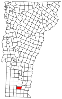
Where is Dover?
Dover covers about 35.3 square miles (91.4 square kilometers) of land. That's like a big park! Two rivers, the Rock River and the North Branch of the Deerfield River, actually start right here in Dover.
What's the Weather Like?
Dover has a climate with big changes between seasons. Summers are warm to hot and can be humid. Winters are cold, sometimes very cold. This type of weather is called a humid continental climate.
How Many People Live Here?
Dover's population has changed a lot over the years. You can see how the number of people living in Dover has grown and shrunk since 1810 in the chart below.
| Historical population | |||
|---|---|---|---|
| Census | Pop. | %± | |
| 1810 | 859 | — | |
| 1820 | 829 | −3.5% | |
| 1830 | 831 | 0.2% | |
| 1840 | 729 | −12.3% | |
| 1850 | 709 | −2.7% | |
| 1860 | 650 | −8.3% | |
| 1870 | 635 | −2.3% | |
| 1880 | 621 | −2.2% | |
| 1890 | 524 | −15.6% | |
| 1900 | 503 | −4.0% | |
| 1910 | 377 | −25.0% | |
| 1920 | 385 | 2.1% | |
| 1930 | 278 | −27.8% | |
| 1940 | 244 | −12.2% | |
| 1950 | 252 | 3.3% | |
| 1960 | 370 | 46.8% | |
| 1970 | 555 | 50.0% | |
| 1980 | 666 | 20.0% | |
| 1990 | 994 | 49.2% | |
| 2000 | 1,410 | 41.9% | |
| 2010 | 1,124 | −20.3% | |
| 2020 | 1,798 | 60.0% | |
| U.S. Decennial Census | |||
In 2000, there were 1,410 people living in Dover. There were 611 households, which are groups of people living together in one home. About 27.5% of these households had kids under 18. The average household had about 2.31 people.
The median age in Dover was 41 years old. This means half the people were younger than 41, and half were older. For every 100 females, there were about 107.7 males.
Famous People from Dover
Dover has been home to some pretty cool people!
- Sherman Adams: He was a governor of New Hampshire, a state next to Vermont.
- Levi Chamberlain: A missionary who traveled to share his beliefs.
- Kelly Clark: A super talented snowboarder who was born in Dover. She even won an Olympic Gold Medal!
- Gardner Howe: He was a state legislator, which means he helped make laws for the state.
- Devin Logan: Another amazing freeskier who won an Olympic Medal.
- Stoyan Christowe: He was a state senator and also a writer.
See also

- In Spanish: Dover (Vermont) para niños
 | Claudette Colvin |
 | Myrlie Evers-Williams |
 | Alberta Odell Jones |


