
Dulverton facts for kids
Quick facts for kids Dulverton |
|
|---|---|
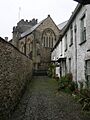
 Church of All Saints |
|

Dulverton
|
|
| Population | 1,408 (2011) |
| OS grid reference | SS9128 |
| Civil parish |
|
| Shire county | |
| Region | |
| Country | England |
| Sovereign state | United Kingdom |
| Post town | DULVERTON |
| Postcode district | TA22 |
| Dialling code | 01398 |
| Police | Avon and Somerset |
| Fire | Devon and Somerset |
| Ambulance | South Western |
| EU Parliament | South West England |
| UK Parliament |
|
Dulverton is a small town and civil parish in west Somerset, England. It's located close to the border with Devon. In 2011, about 1,408 people lived there. The area also includes two small villages called Battleton and Ashwick. Ashwick is about 4 kilometres (2.5 miles) north-west of Dulverton.
Near Ashwick, you can find Ashwick House, a large building from 1901. Another important place nearby is Northmoor. This was once the home of Sir Frederick Wills, whose family helped start the Imperial Tobacco Company. His son, Sir Gilbert Wills, was later given the special title of Baron Dulverton.
Dulverton is a popular place for people who want to explore Exmoor. It's also where the main office for the Exmoor National Park Authority is located. The town is on the path of the Exe Valley Way and the Land's End Trail, which are popular walking routes.
Contents
What's in a Name?
_(cropped).jpg)
The name Dulverton was first written down in 1084. It meant "the settlement at the hidden ford." A "ford" is a shallow place in a river where you can cross. The Domesday Book from 1086 also mentions it as Dolvertune. This old book suggests that Dulverton was a royal area even before the Norman Conquest in 1066.
A Look Back in Time
Dulverton is located near very old Iron Age hillforts. These were fortified settlements built on hills, like Oldberry Castle, Mounsey Castle, and Brewer's Castle.
After the Norman Conquest, William I gave the land to the Turberville family. Later, they gave the church and some land to Taunton Priory, which was a religious house. The rest of the land went to the Shete family. Dulverton was part of a larger area called the Williton and Freemanners Hundred.
During the Middle Ages, Dulverton continued to grow. It became known for its fairs and markets. Many small businesses grew from the local farming and wool trade. For example, there were laundries that washed sheep fleeces in the River Barle. Some of these old laundries still exist today. The market house on Fore Street, built around 1760, became the Dulverton Town Hall in 1866. Its famous porch and double staircase were added in 1930.
In 1568, the Sydenham family bought the land of Dulverton. They lived at Combe House, across the River Barle. Later, in 1858, the Sydenhams sold the land to the Earl of Carnarvon.
Exmoor House was built in 1855 as a workhouse, a place where poor people could live and work. Today, it is the main office for the Exmoor National Park Authority.
Dr. Charles Palk Collyns, a surgeon, lived in Dulverton in the 1800s. He wrote a book called "The Chase of the Wild Red Deer." His gravestone is at All Saints' Church.
Most of the houses in Dulverton are older, from the Georgian and Victorian times. There are also some newer houses and bungalows built after World War II.
How Dulverton is Run
Dulverton has a town council that helps manage local issues. This council sets a small local tax to cover its costs. It also looks at plans for new buildings and works with the police and local groups to keep the area safe. The council helps maintain local facilities and works with the larger county council on roads, footpaths, and public transport. They also care about protecting old buildings and the environment.
Dulverton is part of the larger Somerset unitary authority, which started in 2023. This council handles bigger services like education, social services, libraries, main roads, and public transport. They also manage refuse collection and recycling.
Since Dulverton is inside the Exmoor National Park, the Exmoor National Park Authority also has a special role. This authority focuses on protecting the park's natural beauty, wildlife, and history. They also help people enjoy and understand the park.
Dulverton is the largest part of an area called 'Dulverton and District' for elections. This area stretches north to Winsford. The whole area had about 2,491 people in 2011.
The town is also part of the Tiverton and Minehead area. This area chooses one Member of Parliament (MP) to represent them in the House of Commons in London.
Nature and Rivers

Dulverton sits in the deep, wooded valley of the River Barle. This river valley is a special place for nature, known as a biological Site of Special Scientific Interest.
One famous spot on the river is the Tarr Steps. This is a very old clapper bridge made of large stone slabs. Some people think it dates back to 1000 BC! The stones can weigh up to 5 tons each. A local story says the devil built the bridge to win a bet. The bridge is 55 metres (180 feet) long and has 17 arches. It's a very important historical building.
Other bridges over the River Barle include the Barle Bridge, which is from the Middle Ages. It has been repaired and widened many times over the centuries. The 18th-century Marsh Bridge was also changed and repaired after floods. The New Bridge, built in 1870, leads to Pixton Park, which was once home to famous writers like Evelyn Waugh and Auberon Waugh.
The River Exe also flows near Dulverton, forming part of the boundary with Brompton Regis. Old bridges like Chilly Bridge, Hele Bridge, and Weir Bridge cross the River Exe.
Between the town centre and the river, there's a large open field for recreation. Local people, including students from Dulverton Middle School, helped to improve this area.
South of the town is Briggins Moor, another special nature area. It's home to unique plants like purple moor-grass and meadow thistle. You might also spot the beautiful marsh fritillary butterfly there.
Getting Around

About 3 kilometres (2 miles) from Dulverton is the village of Brushford. This is where the old Dulverton railway station used to be. It was part of the train line from Taunton to Barnstaple. The station opened in 1873 but closed to passengers in 1966. You can still see the old station buildings and where the railway tracks used to run, even though the rails have been removed.
Churches and Worship
The main Church of All Saints in Bank Square has a tower from the 15th century. The rest of the church was rebuilt in the 1850s. It's a very important historical building.
There is also a Congregational Church on Chapel Street, which was built in the 19th century.
Famous People from Dulverton
- Aubrey Herbert: A diplomat and traveller who was given Pixton Park by his mother.
- Auberon Herbert (landowner): He opened up Pixton Park to people from Eastern Europe after World War II.
- John Nelder: A well-known statistician.
- Henry Charles Frank Morant: A writer and photographer.
- Auberon Waugh: A famous writer and journalist, born in 1939 at Pixton Park.
- George Williams: The person who started the YMCA, born in Dulverton in 1821.
- The Wills family: They hold the special title of Lord Dulverton.
Images for kids
-
Church of All Saints
-
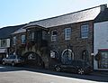
Dulverton Town Hall
-
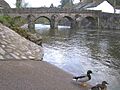
Barle Bridge
-
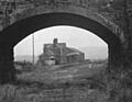
Dulverton station just after the rails were lifted in October 1969
See also
 In Spanish: Dulverton para niños
