Duval County, Texas facts for kids
Quick facts for kids
Duval County
|
|
|---|---|

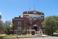
The Duval County Courthouse in San Diego
|
|

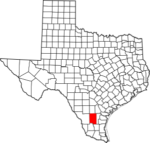
Location within the U.S. state of Texas
|
|
 Texas's location within the U.S. |
|
| Country | |
| State | |
| Founded | 1876 |
| Named for | Burr H. Duval |
| Seat | San Diego |
| Largest city | San Diego |
| Area | |
| • Total | 1,796 sq mi (4,650 km2) |
| • Land | 1,793 sq mi (4,640 km2) |
| • Water | 2.1 sq mi (5 km2) 0.1% |
| Population
(2020)
|
|
| • Total | 9,831 |
| • Density | 5.4738/sq mi (2.1135/km2) |
| Time zone | UTC−6 (Central) |
| • Summer (DST) | UTC−5 (CDT) |
| Congressional district | 28th |
Duval County is a county located in the U.S. state of Texas. In 2020, about 9,831 people lived there. The main city and county seat is San Diego.
The county was started in 1858 and officially organized in 1876. It is named after Burr H. Duval. He was a soldier in the Texas Revolution who sadly died in the Goliad Massacre.
Contents
History of Duval County
Duval County's story began a long time ago, during the time of New Spain (1521–1821). In 1804, a surveyor named Jose Faustino Contreras mapped the area. This map helped attract new settlers from places like Mier, Mexico.
On February 1, 1858, the Texas Legislature officially created Duval County. At first, not many people lived there. Reports from 1867 said there were only a few ranchers. People thought the population would not grow much unless valuable minerals were found.
Soon after, many people from England, France, Germany, Ireland, and Scotland moved to the county. They came to raise sheep. During this busy time, the county seat was a lively place. People enjoyed fancy parties and delicious food.
In April 1878, a large raid by Kickapoo, Seminole, and Lipan Apache groups happened.
In the 1880s, the county became more successful. The Texas Mexican Railway started running in 1881. Its station in San Diego became a key spot for trading animal hides, wool, and cotton. However, this good time ended when many sheep died during a very cold winter in 1886–1887. This led to conflicts, especially affecting the Spanish-speaking population.
In the 1900s, the Parr family became very powerful in local politics. They had a lot of influence in elections in Duval and nearby Jim Wells counties. They were known for helping politicians win elections.
Geography of Duval County
Duval County covers about 1,796 square miles. Most of this area is land (1,793 square miles). Only a small part (2.1 square miles) is water. The county sits over a special underground salt dome called Piedras Pintas. This dome is planned to be used for storing hydrogen in the future.
Main Roads in Duval County
Neighboring Counties
- McMullen County (north)
- Live Oak County (northeast)
- Jim Wells County (east)
- Brooks County (southeast)
- Jim Hogg County (south)
- Webb County (west)
- La Salle County (northwest)
People in Duval County (Demographics)
| Historical population | |||
|---|---|---|---|
| Census | Pop. | %± | |
| 1870 | 1,083 | — | |
| 1880 | 5,732 | 429.3% | |
| 1890 | 7,598 | 32.6% | |
| 1900 | 8,483 | 11.6% | |
| 1910 | 8,964 | 5.7% | |
| 1920 | 8,251 | −8.0% | |
| 1930 | 12,191 | 47.8% | |
| 1940 | 20,565 | 68.7% | |
| 1950 | 15,643 | −23.9% | |
| 1960 | 13,398 | −14.4% | |
| 1970 | 11,722 | −12.5% | |
| 1980 | 12,517 | 6.8% | |
| 1990 | 12,918 | 3.2% | |
| 2000 | 13,120 | 1.6% | |
| 2010 | 11,782 | −10.2% | |
| 2020 | 9,831 | −16.6% | |
| U.S. Decennial Census 1850–2010 2010 2020 |
|||
In 2020, Duval County had a population of 9,831 people. Most people in the county are of Hispanic or Latino background. In 2020, about 81% of the population was Hispanic or Latino.
In 2000, there were 13,120 people living in the county. About 37% of households had children under 18. The average household had almost three people. The average family had about 3.4 people.
The population was spread out by age. About 29.5% were under 18 years old. About 14% were 65 years or older. The average age in the county was 34 years.
Communities in Duval County
Cities
- Benavides
- Freer
- San Diego (county seat) (a small part is in Jim Wells County)
Census-designated places
Unincorporated communities
Ghost towns
Education in Duval County
Several school districts serve the students in Duval County:
- Benavides Independent School District
- Freer Independent School District
- Premont Independent School District
- Ramirez Common School District
- San Diego Independent School District
Coastal Bend College (which used to be Bee County College) is the community college for the county.
See also
 In Spanish: Condado de Duval (Texas) para niños
 | George Robert Carruthers |
 | Patricia Bath |
 | Jan Ernst Matzeliger |
 | Alexander Miles |


