Eagle Peak (Admiralty Island) facts for kids
Quick facts for kids Eagle Peak |
|
|---|---|

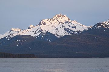
Eagle Peak seen from Douglas Island
|
|
| Highest point | |
| Elevation | 4,650 ft (1,420 m) |
| Prominence | 2,900 ft (880 m) |
| Isolation | 18.33 mi (29.50 km) |
| Parent peak | Admiralty Island High Point (4,850 ft) |
| Geography | |
| Location | Admiralty Island National Monument Hoonah-Angoon Alaska, United States |
| Parent range | Alexander Archipelago Pacific Ranges |
| Topo map | USGS Juneau A-2 |
| Climbing | |
| Easiest route | class 4 scrambling |
Eagle Peak is a tall mountain peak in Alaska, standing at 4,650 feet (about 1,417 meters) high. It is found on Admiralty Island, which is part of the Alexander Archipelago. This peak is the second-highest point on the entire island.
Eagle Peak is located about 14 miles (23 km) southwest of Juneau. It is inside the Admiralty Island National Monument, which is a special protected area. The land around the peak is managed by the Tongass National Forest. Even though it's not the tallest mountain in the world, it rises very steeply from the ocean's edge, called tidewater, at Stephens Passage. The peak climbs about 4.5 miles (7.2 km) from the water. The name "Eagle Peak" was officially given to this mountain by the U.S. Geological Survey in 1951.
Climate Around Eagle Peak
The weather at Eagle Peak is known as a subarctic climate. This means it has very cold winters with lots of snow, and mild summers. Weather systems that come from the Gulf of Alaska hit the mountains and are forced to rise. This causes a lot of rain and snow to fall, a process called orographic lift.
Temperatures can drop very low, sometimes below -20 °C (-4 °F). With the wind chill, it can feel even colder, below -30 °C (-22 °F). If you want to see or climb Eagle Peak, the best time to visit is in July. The weather is usually the most pleasant then.
 | Aurelia Browder |
 | Nannie Helen Burroughs |
 | Michelle Alexander |


