
East Cleveland, Ohio facts for kids
Quick facts for kids
East Cleveland, Ohio
|
|||
|---|---|---|---|

|
|||
|
|||

Location in Cuyahoga County and the state of Ohio
|
|||
| Country | |||
| State | |||
| County | Cuyahoga | ||
| Area | |||
| • Total | 3.09 sq mi (8.00 km2) | ||
| • Land | 3.08 sq mi (7.98 km2) | ||
| • Water | 0.01 sq mi (0.02 km2) | ||
| Elevation | 686 ft (209 m) | ||
| Population
(2020)
|
|||
| • Total | 13,792 | ||
| • Estimate
(2023)
|
13,352 | ||
| • Density | 4,473.56/sq mi (1,727.26/km2) | ||
| Time zone | UTC−5 (Eastern (EST)) | ||
| • Summer (DST) | UTC−4 (EDT) | ||
| ZIP Codes |
44110, 44112, 44118
|
||
| Area code(s) | 216 | ||
| FIPS code | 39-23380 | ||
| GNIS feature ID | 1064577 | ||


East Cleveland is a city in Cuyahoga County, Ohio, United States. It's like a neighbor to the big city of Cleveland. In 2020, about 13,792 people lived there. East Cleveland is located just east and south of Cleveland and west of Cleveland Heights.
Contents
History of East Cleveland
.jpg)
East Cleveland was partly started by Scottish immigrants a long time ago. You can still see their names in the city today, like Shaw and Eddy. East Cleveland officially became a village in 1895. Then, in 1911, it became a city.
When it became a city, East Cleveland did something very special. It allowed women to vote, which was called "women's suffrage." This was very unusual for a city east of the Mississippi River at that time! Before East Cleveland became a city, the bigger city of Cleveland tried to make it part of Cleveland in 1910 and again in 1916, but it didn't work.
East Cleveland is also home to General Electric's famous Nela Park. This was the world's first industrial park, a special area designed for factories and businesses. Nela Park was added to the National Register of Historic Places in 1975, which means it's a very important historical site. Today, it's still the main office for GE Lighting and is one of the city's biggest employers.
During the Great Depression, many large, fancy homes along "Millionaires' Row" were taken down or left empty. Over time, new shops and restaurants replaced some of these homes. However, East Cleveland still has 18 of these original "Millionaire's Row" homes, which is more than the city of Cleveland has left.
After World War II, many new suburbs grew around the area. This brought changes to East Cleveland. By the 1960s, more and more African Americans moved to the city. By 1984, East Cleveland was one of the largest communities in Ohio where most people were Black.
Geography of East Cleveland
East Cleveland is located at 41°31′54″N 81°34′55″W / 41.53167°N 81.58194°W. The city covers about 3.10 square miles (8.00 square kilometers). Most of this area is land, with a tiny bit of water.
Most of East Cleveland is quite flat and sits at a lower height, similar to the city of Cleveland. A smaller part of the city is on a steep hill. This higher area is next to Cleveland Heights. Streets like Superior Road and Forest Hills Boulevard go up this hill. The Forest Hill Historic District, a historic neighborhood, is located on "the hill."
Neighboring Communities
The University Circle area of Cleveland is right next to East Cleveland. It's separated by a railway bridge where the RTA Red Line train runs. In University Circle, you can find places like Case Western Reserve University, University Hospitals Cleveland Medical Center, and the Cleveland Museum of Art.
 |
Cleveland | |
||
| Cleveland | Cleveland Heights | |||
| Cleveland Heights |
People of East Cleveland (Demographics)
| Historical population | |||
|---|---|---|---|
| Census | Pop. | %± | |
| 1880 | 2,876 | — | |
| 1890 | 2,876 | 0.0% | |
| 1900 | 2,757 | −4.1% | |
| 1910 | 9,179 | 232.9% | |
| 1920 | 27,292 | 197.3% | |
| 1930 | 39,667 | 45.3% | |
| 1940 | 39,495 | −0.4% | |
| 1950 | 40,047 | 1.4% | |
| 1960 | 37,991 | −5.1% | |
| 1970 | 39,600 | 4.2% | |
| 1980 | 36,957 | −6.7% | |
| 1990 | 33,096 | −10.4% | |
| 2000 | 27,217 | −17.8% | |
| 2010 | 17,843 | −34.4% | |
| 2020 | 13,792 | −22.7% | |
| 2023 (est.) | 13,352 | −25.2% | |
| Sources: | |||
Homes and Living
East Cleveland has many homes, with about 4,343 houses in every square mile. There are over 13,491 houses in the city. In East Cleveland, about 68% of people rent their homes, which is much higher than the average for Ohio. In 2015, the average rent was about $472 per month. Most people in East Cleveland speak English (95.8%). A smaller number speak Spanish (2.1%) or Russian (1.2%).
Income and Work
In 2011-2015, the average yearly income for families in East Cleveland was about $19,592. Many households (59%) earned less than $25,000 a year. Only 19% of households earned between $25,000 and $44,000. For individuals, the average yearly income was about $14,442.
2020 Census Information
| Race / Ethnicity (NH = Non-Hispanic) | Pop 2000 | Pop 2010 | Pop 2020 | % 2000 | % 2010 | 2020 |
|---|---|---|---|---|---|---|
| White alone (NH) | 1,219 | 796 | 630 | 4.48% | 4.46% | 4.57% |
| Black or African American alone (NH) | 25,291 | 16,532 | 12,314 | 92.92% | 92.65% | 89.28% |
| Native American or Alaska Native alone (NH) | 46 | 38 | 31 | 0.17% | 0.21% | 0.22% |
| Asian alone (NH) | 61 | 40 | 44 | 0.22% | 0.22% | 0.32% |
| Pacific Islander alone (NH) | 4 | 0 | 5 | 0.01% | 0.00% | 0.04% |
| Other race alone (NH) | 34 | 16 | 64 | 0.12% | 0.09% | 0.46% |
| Mixed race or Multiracial (NH) | 355 | 242 | 474 | 1.30% | 1.36% | 3.44% |
| Hispanic or Latino (any race) | 207 | 179 | 230 | 0.76% | 1.00% | 1.67% |
| Total | 27,217 | 17,843 | 13,792 | 100.00% | 100.00% | 100.00% |
2010 Census Information
In 2010, East Cleveland had 17,843 people living there. There were 8,286 households, which are groups of people living together. The city had a population density of about 5,774 people per square mile.
Most of the people in East Cleveland were African American (93.2%). About 4.6% were white. A small number were Native American, Asian, or from other backgrounds. About 1% of the population was Hispanic or Latino.
About 24.9% of households had children under 18. The average household had 2.11 people, and the average family had 3.03 people. The average age in the city was 42.6 years old. About 22.2% of residents were under 18, and 18.8% were 65 or older. More women lived in East Cleveland (54.9%) than men (45.1%).
Economy of East Cleveland

In 2012, East Cleveland had 1,105 businesses owned by people living in the area. A large number of these businesses, 944, were owned by minorities. Also, 733 businesses were owned by women. These numbers are much higher than the averages for Ohio and the whole United States!
Recently, many people who invest in property have shown interest in East Cleveland. This has led to some old buildings being taken down and new ones being built. Historic homes are also being fixed up. Empty properties are being turned into green spaces, especially near Case Western Reserve University and John D. Rockefeller Park.
Major roads like Euclid Avenue and Superior Avenue have also been repaired. This has made the area more attractive and led to more land being bought for new projects.
| % of firms owned by women | % of firms owned by minorities | |
|---|---|---|
| East Cleveland | 66.33% | 85.43% |
| Ohio | 33.91% | 13.56% |
| United States | 35.76% | 28.79% |
Parks and Recreation in East Cleveland
East Cleveland has a wonderful place called Forest Hill Park. It's a huge park, about 248 acres (1 square kilometer) in size. The park has three baseball fields, tennis courts, and walking trails. It keeps its natural green look, just as John D. Rockefeller Jr. wanted when he gave the park to East Cleveland and Cleveland Heights.
Forest Hill Park is the biggest single green park area between two large metroparks in the Cleveland area. The city also has other parks like Pattison Park and Hawley Park for everyone to enjoy.
Infrastructure in East Cleveland

East Cleveland is an important place for public transportation in northeast Ohio. About one-third of all the Greater Cleveland Regional Transit Authority (RTA) bus routes start or end in the city.
The RTA's Red Line train also has its last stop in East Cleveland, at the Windermere Rapid Station on Euclid Avenue. From this station, you can ride the Red Line to many places. These include University Circle, Cleveland State University, Tower City Center in downtown Cleveland, the West Side Market, and even Hopkins International Airport. If you take an RTA bus in East Cleveland, you can reach even more places for jobs, schools, fun, and culture around Cleveland.
Medical Care
East Cleveland has several places for medical care. These include the Candlewood Park Healthcare Center and the Stephanie Tubbs Jones Health Center. Candlewood Park Healthcare Center helps senior citizens with things like outpatient care and rehabilitation. The Stephanie Tubbs Jones Health Center is part of the Cleveland Clinic. It offers many different types of medical help, such as heart care, services for long-term illnesses, diabetes care, and general surgeries.
Education in East Cleveland
When it comes to education levels in East Cleveland, about 34% of adults have a high school diploma. About 37% have attended some college, and 7% have finished a bachelor's degree.
East Cleveland City Schools
The East Cleveland City School District provides public education to more than 3,000 students. The district has seven new or updated school buildings. These updates were part of a big $94 million project to improve schools. In 1997, voters also agreed to add another $10 million to help with the schools' running costs.
The East Cleveland City Schools are working to help students succeed. The district includes Shaw High School, Heritage Middle School (which used to be Kirk Middle School), Chambers Elementary School, Superior Elementary School, Mayfair Elementary School, and Caledonia Elementary School. Prospect Elementary School is now used for administrative offices, and Rozelle Elementary School was closed and later taken down due to fewer students.
The East Cleveland Public Library has its main branch at 14101 Euclid Avenue. In 2009, two smaller branches, Caledonia and North, were closed because of budget cuts and fewer people living in the area. The East Cleveland Public Library joined CLEVNET in 1985, which is a group of libraries that share resources.
Notable People from East Cleveland
- Ed Benedict, animator (draws cartoons)
- Clarence Berger, professional baseball player
- Stephen Blum, ethnomusicologist (studies music from different cultures)
- Yvette Nicole Brown, actress
- JaQuan Hardy, professional football player
- John Henton, actor and comedian
- Dale T. Knobel, historian and academic administrator (runs a university)
- Ruth McKenney, author and journalist (writes books and news)
- Dante Moore, college football player
- Eleanor Parker, actress
- Art Sansom, cartoonist (draws cartoons)
- Bruce F. Scharschmidt, physician (doctor)
- Burt E. Skeel, pilot
- Ernest Sprague, football player, public official, and engineer
- Mike Trivisonno, radio broadcaster
- David John Walkowiak, prelate (a high-ranking church official)
- Bert Wolstein, real estate developer, sports team owner, and philanthropist (gives money to good causes)
Images for kids
-

Flag of East Cleveland
-
Seal of East Cleveland
-
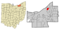
Location in Cuyahoga County and Ohio
See also
 In Spanish: East Cleveland (Ohio) para niños
