
East Greenwich, Rhode Island facts for kids
Quick facts for kids
East Greenwich
|
|
|---|---|

Historic District in downtown East Greenwich
|
|

Location of East Greenwich in Kent County, Rhode Island (top) and of Kent County in Rhode Island (below)
|
|
| Country | United States |
| State | Rhode Island |
| County | Kent |
| Incorporated | 1677 |
| Government | |
| • Type | Town Council and Manager |
| Area | |
| • Total | 16.71 sq mi (43.3 km2) |
| • Land | 16.58 sq mi (42.9 km2) |
| • Water | 0.14 sq mi (0.4 km2) |
| Elevation | 207 ft (63 m) |
| Population
(2020)
|
|
| • Total | 14,312 |
| • Density | 863.2/sq mi (333.3/km2) |
| Time zone | UTC−5 (Eastern (EST)) |
| • Summer (DST) | UTC−4 (EDT) |
| ZIP Code |
02818
|
| Area code(s) | 401 |
| FIPS code | 44-22240 |
| GNIS feature ID | 1220085 |
| Website | www.eastgreenwichri.com |
East Greenwich is a historic town located in Rhode Island. It is the main town of Kent County. In 2020, about 14,312 people lived here. East Greenwich is known as the wealthiest town in Rhode Island. It is also part of the larger Providence and Boston city areas.
The town was first called Greenwich in 1677, named after Greenwich, England. It was briefly renamed Dedford, but soon went back to its original name. In 1741, the western part of the town became West Greenwich. The remaining part was then called East Greenwich. Until 1854, East Greenwich was one of Rhode Island's five state capitals. The local courthouse, now the town hall, was used for meetings. Today, East Greenwich is famous for its beautiful waterfront, excellent schools, and lively downtown area with many restaurants and shops.

Contents
Discovering East Greenwich History
East Greenwich is the 8th oldest town in Rhode Island. It was founded in October 1677 by the General Assembly. This was done to protect land claims against Connecticut and other groups. The Assembly set aside 5,000 acres for the new town. They offered land to settlers who agreed to live there. Many of these settlers were 48 men who fought in King Phillip's War. This quick settlement helped stop Connecticut from expanding its borders. East Greenwich is special because it was the only Rhode Island town created by the government. Other towns were started by businesses.
Early Growth and Changes
In the 1700s, the government opened up waterfront land. Starting in 1711, they gave small plots to anyone who would pay a small fee. People also had to promise to build a business building. By 1725, a small community had grown. It had a schoolhouse and a graveyard. However, the town was very large. Citizens found it hard to attend town meetings. This led to West Greenwich becoming its own town in 1741.
East Greenwich became the main town for the new Kent County in 1750. A courthouse was built there. On June 12, 1772, a big decision was made in East Greenwich. The Rhode Island State Assembly decided to create the first United States Navy. This navy had two ships, the Katy and the Washington. Captain Abraham Whipple was put in charge.
The Story of Scalloptown
In the 1800s, many immigrants came to East Greenwich. They came from Ireland, Italy, Germany, and Scandinavian countries. Free Black people also moved there. Many of these new residents settled in a community called Scalloptown. They often earned a living by fishing and selling scallops.
As Scalloptown grew, some people saw it as a "shantytown." They thought it was a rough place. The neighborhood was busiest from 1890 to 1913. In 1913, the town council decided many homes in Scalloptown were not safe. Most of Scalloptown was destroyed by 1926. This happened after the town council ordered many buildings to be emptied.
Scalloptown had been a focus for social reformers. A "Neighborhood House" was run by Sarah Fernandis starting in 1908. However, some historians believe that racial bias played a role in the destruction of Scalloptown. Today, only one shellfish business remains on the street. The true Scalloptown area runs from the town dock past the clubs to Finn's Marina.
East Greenwich Geography
East Greenwich is a town located on the coast. It sits on the western side of Narragansett Bay. The total area of the town is about 16.71 square miles. Most of this, 16.58 square miles, is land. The rest, 0.14 square miles, is water. About 20 percent of East Greenwich's land is undeveloped. This includes woods and farmland. However, new buildings are slowly reducing this amount.
The town shares borders with its neighbors. Division Street is a rough border between East Greenwich and Warwick to the north and west. To the south and east, North Kingstown is separated by Frenchtown Road.
East Greenwich Climate
East Greenwich has a climate with warm summers. It is known as a humid continental climate. This means it has four distinct seasons. Summers are generally warm and humid. Winters are cold with snow.
| Climate data for East Greenwich, 1991–2020 simulated normals (79 ft elevation) | |||||||||||||
|---|---|---|---|---|---|---|---|---|---|---|---|---|---|
| Month | Jan | Feb | Mar | Apr | May | Jun | Jul | Aug | Sep | Oct | Nov | Dec | Year |
| Mean daily maximum °F (°C) | 37.9 (3.3) |
39.7 (4.3) |
46.4 (8.0) |
56.8 (13.8) |
67.1 (19.5) |
75.9 (24.4) |
81.7 (27.6) |
80.6 (27.0) |
74.1 (23.4) |
63.1 (17.3) |
52.7 (11.5) |
43.2 (6.2) |
59.9 (15.5) |
| Daily mean °F (°C) | 29.7 (−1.3) |
31.3 (−0.4) |
38.1 (3.4) |
48.2 (9.0) |
58.1 (14.5) |
67.3 (19.6) |
73.4 (23.0) |
72.1 (22.3) |
65.3 (18.5) |
54.3 (12.4) |
44.2 (6.8) |
35.4 (1.9) |
51.5 (10.8) |
| Mean daily minimum °F (°C) | 21.6 (−5.8) |
22.8 (−5.1) |
29.8 (−1.2) |
39.6 (4.2) |
49.1 (9.5) |
58.8 (14.9) |
64.9 (18.3) |
63.7 (17.6) |
56.7 (13.7) |
45.5 (7.5) |
35.8 (2.1) |
27.7 (−2.4) |
43.0 (6.1) |
| Average precipitation inches (mm) | 4.16 (105.57) |
3.52 (89.36) |
5.26 (133.65) |
4.63 (117.72) |
3.44 (87.32) |
3.97 (100.77) |
3.25 (82.48) |
3.79 (96.32) |
4.07 (103.46) |
4.65 (118.18) |
4.29 (108.88) |
4.96 (126.06) |
49.99 (1,269.77) |
| Average dew point °F (°C) | 19.6 (−6.9) |
20.5 (−6.4) |
25.7 (−3.5) |
34.7 (1.5) |
46.6 (8.1) |
57.2 (14.0) |
63.5 (17.5) |
63.0 (17.2) |
56.8 (13.8) |
45.5 (7.5) |
34.5 (1.4) |
26.2 (−3.2) |
41.2 (5.1) |
| Source: PRISM Climate Group | |||||||||||||
East Greenwich Schools

East Greenwich has six public schools. Students attend different elementary schools based on where they live. If you live east of South County Trail, you go to Meadowbrook Farms for kindergarten to second grade. Then you move to George R. Hanaford School for third to fifth grade.
If you live west of South County Trail, you attend Frenchtown Elementary for kindergarten to second grade. After that, you go to James H. Eldredge School for third to fifth grade. All public school students then attend Archie R. Cole Middle School for sixth to eighth grade. The town's only high school is East Greenwich High School.
In 2015, Newsweek magazine ranked East Greenwich High School as the best in Rhode Island. It was also ranked 186th in the entire United States.
The town also has a private Catholic school. It is called Our Lady Of Mercy Regional School. It serves students from pre-kindergarten up to eighth grade. East Greenwich was once home to the East Greenwich Academy. This was a well-known preparatory school, but it closed in 1943.
East Greenwich is also home to the main campus of the New England Institute of Technology. This school is often called New England Tech. The school bought the land in 2007. It opened to students in the summer of 2011. A big expansion started in 2014. This added dorms and new learning spaces. The campus has a large building for classrooms, labs, and medical training areas.
East Greenwich Public Library

The East Greenwich Free Library is located at 82 Pierce Street. It was given to the town by Daniel Albert Peirce in 1913. Mr. Peirce lived in East Greenwich. He also helped start the Narragansett Electric Company. The library building is made of granite from Coventry, Rhode Island. It was officially opened on June 29, 1915. The library has special collections. These include books and records about Rhode Island history and family trees.
East Greenwich Waterfront
The waterfront in East Greenwich is a popular spot. Many restaurants, bars, and clubs are located there. East Greenwich Cove also has plenty of space for boats to park. There is a public dock where people can fish or enjoy the views. There is also a small beach.
Across the water from the coast is Goddard Memorial State Park. This park has many beaches, including Sandy Point. It is easy to get to from East Greenwich Cove. Scalloptown Park has been built at the southern end of Greenwich Cove. This park is on the site of an old town landfill.
National Historic Places in East Greenwich
East Greenwich is home to several places listed on the National Register of Historic Places. These sites are important for their history and architecture.
- Armory of the Kentish Guards
- Clement Weaver-Daniel Howland House
- Col. Micah Whitmarsh House
- East Greenwich Historic District
- Fry's Hamlet Historic District
- Gen. James Mitchell Varnum House
- Kent County Courthouse
- Massie Wireless Station
- Richard Briggs Farm
- Tillinghast Mill Site
- Tillinghast Road Historic District
- Windmill Cottage
Adjacent Towns
 |
Coventry | West Warwick, Warwick | |
|
| West Greenwich | Warwick | |||
| Exeter | North Kingstown |
Images for kids
-
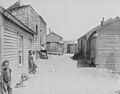
Scalloptown shanties in the early 20th Century
-
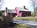
Clement Weaver House, a historic stone ender built in 1679, is one of the oldest homes in Rhode Island.


See also
 In Spanish: East Greenwich (Rhode Island) para niños
