East Hartford, Connecticut facts for kids
Quick facts for kids
East Hartford, Connecticut
|
|||
|---|---|---|---|
|
Town
|
|||
| Town of East Hartford | |||
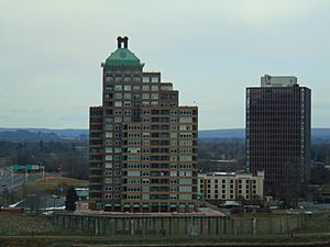
The skyline near the Connecticut River
|
|||
|
|||
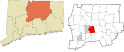
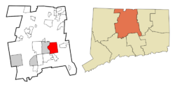 Hartford County and Connecticut Hartford County and Connecticut |
|||
| Country | |||
| U.S. state | |||
| County | Hartford | ||
| Region | Capitol Region | ||
| Incorporated | 1783 | ||
| Government | |||
| • Type | Mayor-council | ||
| Area | |||
| • Total | 18.7 sq mi (48.5 km2) | ||
| • Land | 18.0 sq mi (46.6 km2) | ||
| • Water | 0.7 sq mi (1.9 km2) | ||
| Elevation | 49 ft (15 m) | ||
| Population
(2020)
|
|||
| • Total | 51,045 | ||
| • Density | 2,837/sq mi (1,095.4/km2) | ||
| Time zone | UTC−5 (Eastern) | ||
| • Summer (DST) | UTC−4 (Eastern) | ||
| ZIP Codes |
06108, 06118
|
||
| Area code(s) | 860/959 | ||
| FIPS code | 09-22630 | ||
| GNIS feature ID | 0213424 | ||
| Interstates | |||
| U.S. Highways | |||
| State Routes | |||
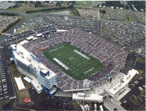
East Hartford is a town in the Capitol Planning Region, Connecticut, United States. It has a population of about 51,045 people, based on the 2020 census. The town is located on the east side of the Connecticut River, right across from the city of Hartford. East Hartford is known for being home to Pratt & Whitney, a big company that makes airplane engines. It also has Pratt & Whitney Stadium at Rentschler Field, a large stadium used for soccer and football games.
Contents
History of East Hartford
When Europeans first explored the Connecticut Valley around 1631, Native American tribes lived there. These were called the River Tribes. The Podunks lived in the area that is now East Hartford and South Windsor. They had leaders called sachems.
In 1659, Thomas Burnham bought land from the Podunk chief, Tantinomo. This land became South Windsor and East Hartford. The town of Hartford, started in 1635, once included East Hartford and other nearby towns. During the American Revolutionary War, French troops led by Lieutenant General Comte de Rochambeau camped in East Hartford. They were helping George Washington's army.
East Hartford became its own separate town in October 1783. Later, Manchester separated from East Hartford in 1823. Over time, the town created special districts for services like fire protection and street lighting. In 1929, a new town government was set up with a Town Council. This council took over from the old districts.
For a long time, East Hartford's economy was mostly farming, especially growing tobacco. But this changed in 1929 when Frederick Rentschler, who led Pratt & Whitney, moved his company's production to East Hartford. The company built a huge site that included a small airport called Rentschler Field. This airport was used for testing planes and corporate flights until 1999. Later, the airport land was given to the state of Connecticut. A new Pratt & Whitney Stadium at Rentschler Field was built there. It opened as a stadium with space for 40,000 people. The UConn football team plays its home games there.
Geography of East Hartford
East Hartford is located on the eastern bank of the Connecticut River, directly opposite Hartford. The town includes areas like Burnside, Hockanum, and Mayberry Village. The total area of the town is about 48.5 square kilometers (18.7 square miles). Most of this is land, with a small part being water.
East Hartford's Climate
| Climate data for East Harford (1991–2020 normals) | |||||||||||||
|---|---|---|---|---|---|---|---|---|---|---|---|---|---|
| Month | Jan | Feb | Mar | Apr | May | Jun | Jul | Aug | Sep | Oct | Nov | Dec | Year |
| Mean daily maximum °F (°C) | 36.1 (2.3) |
38.8 (3.8) |
46.9 (8.3) |
59.5 (15.3) |
70.3 (21.3) |
78.8 (26.0) |
84.2 (29.0) |
82.8 (28.2) |
75.6 (24.2) |
63.5 (17.5) |
51.8 (11.0) |
41.5 (5.3) |
60.8 (16.0) |
| Daily mean °F (°C) | 27.9 (−2.3) |
29.8 (−1.2) |
37.9 (3.3) |
49.5 (9.7) |
60.1 (15.6) |
68.9 (20.5) |
74.5 (23.6) |
72.9 (22.7) |
65.5 (18.6) |
53.6 (12.0) |
42.8 (6.0) |
33.6 (0.9) |
51.4 (10.8) |
| Mean daily minimum °F (°C) | 19.4 (−7.0) |
21.0 (−6.1) |
28.8 (−1.8) |
39.4 (4.1) |
49.6 (9.8) |
59.0 (15.0) |
64.6 (18.1) |
63.0 (17.2) |
55.4 (13.0) |
43.7 (6.5) |
33.8 (1.0) |
25.7 (−3.5) |
41.9 (5.5) |
| Average precipitation inches (mm) | 3.65 (93) |
3.22 (82) |
4.33 (110) |
4.16 (106) |
3.51 (89) |
4.61 (117) |
4.54 (115) |
4.60 (117) |
4.48 (114) |
4.76 (121) |
3.63 (92) |
4.73 (120) |
50.22 (1,276) |
| Average dew point °F (°C) | 18.3 (−7.6) |
19.0 (−7.2) |
24.6 (−4.1) |
34.5 (1.4) |
46.9 (8.3) |
57.6 (14.2) |
63.3 (17.4) |
62.6 (17.0) |
56.3 (13.5) |
44.6 (7.0) |
33.1 (0.6) |
24.6 (−4.1) |
40.5 (4.7) |
| Source 1: NCEI(precipitation) | |||||||||||||
| Source 2: PRISM Climate Group | |||||||||||||
People in East Hartford
In 2021, about 50,731 people lived in East Hartford. There were over 20,200 households. The town has a mix of different groups of people. About 32.6% of residents were non-Hispanic White, 24.8% were Black or African American, and 3.7% were Asian. People of Hispanic or Latino background made up 38.2% of the population. Many people have moved to East Hartford from Hartford or from other areas.
About 29.2% of households had children under 18 living there. The average household had 2.42 people. The median age in East Hartford was 37 years old. This means half the people were younger than 37, and half were older.
East Hartford's Economy
East Hartford is home to the main office of Pratt & Whitney. This company is part of Raytheon Technologies. The factory takes up a lot of space in East Hartford. In the past, tens of thousands of people worked there. Today, about 7,621 people work at Pratt & Whitney in East Hartford.
The town also has a Coca-Cola bottling plant. You can find industrial and office parks throughout the city. In the early 2000s, a large stadium, Rentschler Stadium, was built on the old Pratt & Whitney airport land. A big outdoor store called Cabela's was also built there.
Main Employers in East Hartford
Here are some of the biggest employers in East Hartford:
| # | Employer | # of Employees |
|---|---|---|
| 1 | Pratt & Whitney | 8,000 |
| 2 | Town of East Hartford | 1,716 |
| 3 | Goodwin University | 533 |
| 4 | Riverside Health Center | 385 |
| 5 | American Eagle Federal Credit Union | 331 |
| 6 | Connecticut Natural Gas | 310 |
| 7 | Raytheon Technologies | 275 |
| 8 | Hoffman Auto | 249 |
| 9 | Gengras Motor Cars | 244 |
| 10 | Coca Cola Bottling Company | 199 |
Town Services
Utilities in East Hartford
- Electricity: Eversource Energy
- Water: Metropolitan District Commission
- Natural gas: Connecticut Natural Gas
- Phone, internet, TV: Frontier Communications
- Cable TV/Internet: Comcast
Education in East Hartford
East Hartford has several schools and colleges:
- Connecticut River Academy
- Goodwin University
- East Hartford High School
- Stone Academy
- Connecticut International Baccalaureate Academy
- East Hartford Middle School
Fun Places to Visit
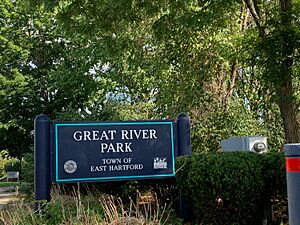
The Great River Park is a cool place along the Connecticut River in East Hartford. You can enjoy different activities by the river there.
Wickham Park is partly in East Hartford and partly in Manchester. It has beautiful Oriental gardens, fountains, open fields, and woodlands. There are also ponds, picnic areas, and even an aviary (a place for birds). From the west side of the park, you can see a great view of East Hartford and the Hartford skyline. It's a popular spot for weddings and sledding in the winter.
Close by, Pratt & Whitney Stadium at Rentschler Field is where the Huskies football team plays their home games.
Famous People from East Hartford
- Milton Avery, artist
- Lawrence Brainerd, businessman and senator
- Mary Cadorette, actress
- Howard Ensign Evans, famous bug expert
- Francis Patrick Garvan, lawyer
- John A. Gurley, U.S. Representative
- John Larson, current U.S. Representative
- Hiram N. Moulton, mayor of Madison, Wisconsin
- Aaron Olmsted, sea captain
- Denison Olmsted, physicist and astronomer
- Frederick Law Olmsted, famous urban planner
- Gérard Ouellet, Canadian politician
- Charles Phelps, first Connecticut Attorney General
- Diane Venora, actress
- Patrick Agyemang, Major League Soccer player
See also
 In Spanish: East Hartford para niños


