
Econlockhatchee River facts for kids
Quick facts for kids Econlockhatchee River |
|
|---|---|

Econlockhatchee River from the Florida Trail bridge
|
|
| Other name(s) | Econ River |
| Country | United States |
| Location | Central Florida |
| Physical characteristics | |
| Main source | Lake Conlin north of Holopaw 92 feet (28 m) 28°14′29″N 81°6′31″W / 28.24139°N 81.10861°W |
| River mouth | St. Johns River near Puzzle Lake 3 feet (0.91 m) 28°42′13″N 81°1′42″W / 28.70361°N 81.02833°W |
| Length | 87.7 kilometres (54.5 mi) |
| Basin features | |
| Progression | Ecolockhatchee - Saint Johns River - Atlantic Ocean |
| River system | Saint Johns River |
| Basin size | 173,143 acres (700.68 km2) |
| Tributaries |
|
The Econlockhatchee River, often called the Econ River, is a cool, dark-water river in Central Florida. It flows north for about 54 miles (87.7 kilometers) and is an important branch of the St. Johns River. The Econ River winds through Osceola, Orange, and Seminole counties. It is just east of the big city of Orlando. The river is so special that it's been named an "Outstanding Florida Water". This means it's protected for its natural beauty and importance.
Contents
What's in a Name?
People aren't completely sure where the name "Econlockhatchee" comes from. In 1839, it was written as "Econ-like Hatchee." Some experts think this name comes from the Muscogee language. It might mean "earth-mound stream." The word "econ-like" could come from ēkvnv, meaning 'earth' or 'land', and like, meaning 'sitting'. Then, hvcce means 'stream'. So, it could describe a stream with mounds of earth nearby.
The River's Journey
The Econ River starts its journey at Lake Conlin. This lake is its source. From there, the river flows north through a large wetland area called the Econlockhatchee River Swamp. This swamp is south of State Road 528.
As the river continues, it passes near the city of Oviedo. Here, a smaller river, the Little Econlockhatchee River, joins it. After this, the Econ River turns east and flows through the Little Big Econ State Forest. Finally, the Econlockhatchee River meets the St. Johns River near Puzzle Lake. The land along the river is covered in forests for its entire length.
Exploring the Econlockhatchee River Swamp
The upper part of the Econlockhatchee River is known as the Econlockhatchee River Swamp. This swamp is southeast of Orlando. It stretches for about 13 miles (21 kilometers) from Lake Conlin to State Road 528.
South of State Road 532, this swamp is called Cat Island Swamp. It got its name from an island close to County Road 500A. In this area, the river is at its widest, about 1 mile (1.6 kilometers) across. Lake Preston is located to the west of this wide section.
Further downstream, the river's elevation is about 62 feet (19 meters). The Disston Canal connects Lake Mary Jane and Lake Hart to the swamp. Turkey Creek Bay is another part of the swamp. The Turkey Creek flows through this bay. North of Wewahootee Road, the Econlockhatchee River leaves the swamp. From there, it flows freely until it reaches the St. Johns River.
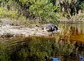
Gallery
River views


Fauna
-
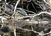
Young alligators along the river bank
-
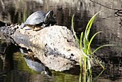
A Florida cooter sunning on top of a log
-


.jpg)
