
El Mirage, Arizona facts for kids
Quick facts for kids
El Mirage, Arizona
|
|||
|---|---|---|---|

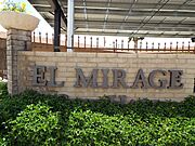
Entrance to the city of El Mirage
|
|||
|
|||

Location in Maricopa County, Arizona
|
|||

El Mirage, Arizona
Location in Arizona

El Mirage, Arizona
Location in the United States
|
|||
| Country | United States | ||
| State | Arizona | ||
| County | Maricopa | ||
| Area | |||
| • Total | 9.95 sq mi (25.78 km2) | ||
| • Land | 9.90 sq mi (25.63 km2) | ||
| • Water | 0.06 sq mi (0.15 km2) | ||
| Elevation | 1,283 ft (391 m) | ||
| Population
(2020)
|
|||
| • Total | 35,805 | ||
| • Density | 3,617.40/sq mi (1,396.72/km2) | ||
| Time zone | UTC-7 (MST (no DST)) | ||
| ZIP code |
85335
|
||
| Area code(s) | 623 | ||
| FIPS code | 04-22220 | ||
| GNIS feature ID | 24845 | ||


El Mirage is a city located in Maricopa County, Arizona, in the United States. In 2020, about 35,805 people lived there. This number was higher than the 31,797 people counted in 2010.
Contents
History of El Mirage
Early Settlers and Farmers
Long ago, the Hohokam Native American tribe lived in the area that is now El Mirage. These clever people built amazing irrigation systems. They used only stone tools and worked together to dig canals. Because of this, they were known as the "Canal Builders."
In the early 1930s, people who traveled to find farm work, called migrant farm workers, settled in El Mirage. They lived on the west side of the Agua Fria River. Many Mexican workers came to help build canals and harvest the first crops. Even today, farming is important to El Mirage. But the city has also grown with new industries and become a diverse community.
City Growth and Challenges
In 1977, El Mirage expanded its land by about 2,000 acres. The city planned to build new homes, shopping areas, and factories. However, the Attorney General, Bruce Babbitt, tried to stop this expansion. He was worried because the land was very close to Luke Air Force Base. The lawsuit failed, but it made nearby cities like Glendale and Goodyear buy land around the base. They wanted to prevent any more city growth too close to the base.
In the early 1980s, El Mirage announced big plans to improve its economy. The city wanted to build more houses. The main idea was a large resort and convention center, costing $20 million, with a golf course. They also thought about adding a baseball stadium for spring training, a medical center, and a car sales area.
Concerns from Luke Air Force Base
These plans were only five miles north of the Air Force base's runway. Officials from Luke Air Force Base and other government leaders became worried. They started to turn public opinion against the project. City officials went to Washington D.C. to argue their case. They said the base knew about the land purchases earlier. They felt the base should have spoken up before the city spent money on the plans.
In the end, nothing was built on the land. This was mostly because of the concerns from Luke Air Force Base. Because of these past issues, El Mirage had a different view in 2009. When Luke Air Force Base wanted to get new F-35 fighter jets, many nearby cities supported the base. They wanted the base to stay busy. But El Mirage spoke out against it. The city believed the base had stopped its financial growth in the past and would continue to do so.
Becoming a City
El Mirage officially became a town on June 25, 1951. In 1983, the people voted in a special election for it to become a city. El Mirage has continued to grow ever since.
Geography of El Mirage
El Mirage is located next to the Agua Fria River and U.S. Route 60. It is in the northwest part of the larger Phoenix metropolitan area. To the east, it borders Youngtown. To the south, it borders Glendale. Surprise is to the northwest, and Sun City is to the northeast. Downtown Phoenix is about 19 miles (30 km) to the southeast.
The city covers a total area of about 9.95 square miles (25.78 km²). A very small part of this, about 0.06 square miles (0.15 km²), is water.
Climate in El Mirage
El Mirage has a desert climate, which means it's usually very hot and dry. Summers are extremely hot, with temperatures often going over 100°F (38°C). Winters are mild and pleasant. The area doesn't get much rain, but when it does, it's often during the summer monsoon season.
Population and People
| Historical population | |||
|---|---|---|---|
| Census | Pop. | %± | |
| 1960 | 1,723 | — | |
| 1970 | 3,258 | 89.1% | |
| 1980 | 4,307 | 32.2% | |
| 1990 | 5,001 | 16.1% | |
| 2000 | 7,609 | 52.1% | |
| 2010 | 31,797 | 317.9% | |
| 2020 | 35,805 | 12.6% | |
| U.S. Decennial Census | |||
In 2000, about 7,609 people lived in El Mirage. The city has grown a lot since then, reaching over 35,000 people by 2020. Many families live in El Mirage, and a large number of households have children. The city is also close to Luke U.S. Air Force Base. This base is the biggest training center for fighter pilots in the North Atlantic Treaty Organization (NATO).
Education in El Mirage
About 5,500 students from pre-kindergarten to 12th grade in El Mirage attend schools in the Dysart Unified School District.
Public Elementary Schools
- El Mirage Elementary - opened in 1958
- Surprise Elementary - opened in 1976
- Thompson Ranch Elementary - opened in 2004
- Riverview Elementary - opened in 2008
- Dysart Middle School - opened in 2021
Public High Schools
- Dysart High School - opened in 1963
- Sundown Mountain - opened in 2004, an alternative school for only 11th and 12th graders
- Valley Vista High School - opened in 2006. Even though it's not in El Mirage, students living north of Waddell Road/Thunderbird Road go to this school.
El Mirage also has several private schools. These include Desert Choice School, which is specially designed for students with special education needs. There is also Sun Valley Christian School, and Valley Learning Center, which is a preschool and daycare.
Historic Structures of El Mirage
-
Front of the former city hall building.
-
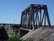
Historic El Mirage Agua Fria River Bridge built in 1895.
-
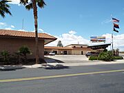
Former El Mirage City Hall located at 12145 NW Grand Ave.
-
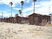
El Mirage Motel. These are the individual rooms of the motel which were used by motorist who traveled through Grand Ave.
-
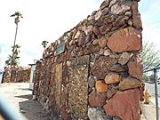
El Mirage Motel was built out of fieldstone in 1937 and is located at 12229 NW Grand Ave. The property has now been demolished.


See also
 In Spanish: El Mirage para niños
