
Eldorado Mountain facts for kids
Quick facts for kids Eldorado Mountain |
|
|---|---|

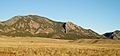
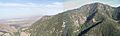
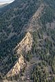
Eldorado Mountain from the east in August 2007
|
|
| Highest point | |
| Elevation | 8,344 ft (2,543 m) |
| Prominence | 640 ft (195 m) |
| Isolation | 1.76 mi (2.83 km) |
| Geography | |

Eldorado Mountain
Location in Colorado
|
|
| Location | Boulder and Jefferson counties, Colorado, United States |
| Parent range | Front Range |
| Topo map | USGS 7.5' topographic map Eldorado Springs, Colorado |
| Climbing | |
| Easiest route | hike |
Eldorado Mountain is a cool mountain peak in the Rocky Mountains of North America. It's part of the Front Range in Colorado, United States. This peak stands tall at about 8,344 feet (2,543 meters).
The mountain is located about 8 miles (13 kilometers) southwest of downtown Boulder. Most of Eldorado Mountain is in Boulder County. However, its southern side crosses into Jefferson County. The mountain probably got its name from the nearby town of Eldorado Springs.
Contents
Who Owns Eldorado Mountain?
On the Boulder County side, the City of Boulder owns about half of the mountain. Other parts are owned by Boulder County, Eldorado Canyon State Park, and the Bureau of Land Management. On the Jefferson County side, different private owners have land.
How Big is Eldorado Mountain?
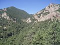
The lowest part of the mountain is about 5,800 feet (1,768 meters high). This means the mountain rises about 2,500 feet (762 meters) from its base to its top. At its widest, the mountain stretches about 2 miles (3 kilometers) across.
The very top of Eldorado Mountain is owned by the City of Boulder. For safety, the public cannot go to the summit. There are no trails that lead directly to the top.
Near the mountain's peak, you can see a large area with antennas and two buildings. The radio station KBCO sends out its signal from here. A private dirt road leads to this site. It starts in a small community called Plainview and climbs up the mountain's steep southern side.
Exploring the East Side
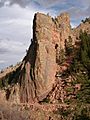
The east side of Eldorado Mountain has a huge cliff called Mickey Mouse Wall. If you look at it from the north, two rock formations at the top look like mouse ears! But from the east, it looks more like one of the famous flatirons in Boulder.
The only path on this side is a small trail for rock climbers going to Mickey Mouse Wall. There are also old remains of the Conda Quarry on the east side. This quarry was a place where rocks were dug out from the 1950s to the 1980s. In 1992, the City of Boulder bought the quarry land to protect it as open space. They worked to clean up the site, but you can still see where the quarry was.
Discovering the North Side
To the north of Eldorado Mountain flows South Boulder Creek. This large creek starts high up near the Continental Divide. It flows through Gross Reservoir and later joins Boulder Creek.
Eldorado Canyon State Park is located along this creek. Inside the park, you can find the Rattlesnake Gulch Trail. This trail climbs about halfway up the north side of Eldorado Mountain. Near the top of this trail are the ruins of the old Crags Hotel. This hotel was open from 1908 until it burned down in 1913. The park has turned the hotel ruins into a cool historic spot for visitors. When the hotel was open, it even had a special funicular (a type of cable railway) that went down to the creek.
Also on the north side are three thin cliffs stacked up: Continental Crag, Upper Peanuts Wall, and Lower Peanuts Wall. At the very bottom of the mountain's north side is a famous tower-like rock called The Bastille. Further down the creek is the small community of Eldorado Springs.
Railroads and Waterways
The northern side of Eldorado Mountain has four different lines running across it. These include two old railroad paths and two aqueducts (water channels).
Union Pacific Railroad Line
The highest line, at about 7,100 feet (2,164 meters), is an active railroad line. It's owned and used by Union Pacific Railroad. This line goes around three-quarters of the mountain and passes through many tunnels. It was built starting in 1902 and was known as Moffat Road. Further west, this line goes through the Moffat Tunnel under the Continental Divide. Amtrak’s California Zephyr train uses this line every day.
South Boulder Diversion Aqueduct
Another line, around 6,300 feet (1,920 meters) high, is an aqueduct called the South Boulder Diversion. This aqueduct carries water to Ralston Reservoir. It helps supply drinking water to Denver and its nearby towns. It was built in 1937 and is managed by Denver Water. Near Eldorado Mountain, this aqueduct is mostly hidden in tunnels. But in a few short spots, you can see it as a large pipe above ground. Further east, it turns into a canal.
Denver Utah & Pacific Railroad Grade
A third line, at about 6,100 feet (1,859 meters), is another old railroad path. It was planned in the 1880s by the Denver, Utah and Pacific Railroad. However, no tracks were ever laid, so historians call it a "ghost" railroad. After the railroad left, people used this path to get to the west side of the canyon. It was the only way to access that area until a new road was built in 1927. In 1978, part of this old path became part of Eldorado Canyon State Park. It was later turned into the Fowler Trail, which is great for hiking.
Community Ditch
The lowest line, at about 5,800 feet (1,768 meters), is called the Community Ditch. It starts at a special dam near the entrance to Eldorado Canyon State Park. This ditch carries water to Marshall Lake, about 3 miles (5 kilometers) to the east. It was built around 1908 and is owned by the Farmers Reservoir and Irrigation Company.
Gallery
-
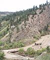
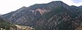
Northeast toe, lowest point
-
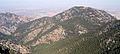
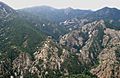
NNE view
-
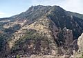
The Conda Quarry
-
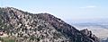
ENE view
-
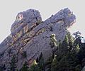
The Mouse Ears
-
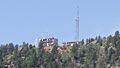
Antenna field near the top
-
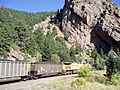
Union Pacific train, with Mickey Mouse Wall
-
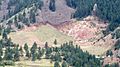
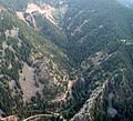
Bull Gulch
-
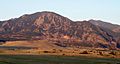
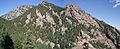
SE view
-
SSE view
-
SW view
-
WSW view
-
NW view
-
NNW view
-
South Draw
-
Rattlesnake Gulch
-
Continental and Peanuts
-
The Bastille
-
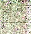
Portion of USGS Topo Map


