
Elliott Knob facts for kids
Quick facts for kids Elliott Knob |
|
|---|---|

Elliott Knob (summit on right)
|
|
| Highest point | |
| Elevation | 4,463 ft (1,360 m) |
| Prominence | 2,423 ft (739 m) |
| Geography | |

Elliott Knob
Location in Virginia

Elliott Knob
Location in the United States
|
|
| Location | Augusta County, Virginia, U.S. |
| Parent range | Ridge-and-Valley Appalachians Shenandoah Mountain |
| Topo map | USGS Elliott Knob |
| Climbing | |
| First ascent | Prehistoric |
| Easiest route | Hike |
Elliott Knob is one of the tallest mountains in the northern part of Virginia, a state in the United States. It stands at about 4,463 feet (1,360 meters) high. This peak is part of a larger ridge called Great North Mountain.
Not far from the main peak, there's a smaller peak named "Hogback." It's about 4,447 feet (1,355 meters) tall and is located about half a mile southwest.
On top of Elliott Knob, you can find a special group of red spruce trees. The higher parts of the mountain also have yellow birch and sugar maple trees. These trees usually grow much farther north, showing that Elliott Knob is high enough to have a cooler climate. Most of the mountain is covered in oak and hickory trees. The entire mountain is located within the George Washington and Jefferson National Forests.
Wildlife on Elliott Knob
The area around Elliott Knob is home to many different animals. You might spot black bears, white-tailed deer, and the shy bobcat.

Exploring the Mountain
There's a rough jeep trail that goes up the mountain from the east. However, this trail is closed to regular cars. The Forest Service uses it to reach a fire lookout tower at the top. This trail is very steep, climbing over 2,000 feet (610 meters) in less than 2.5 miles (4 kilometers).
The town of Augusta Springs, Virginia is about 4 miles (6.4 kilometers) south of the mountain. It sits about 2,800 feet (853 meters) below the summit. The only way for people to reach the top of Elliott Knob is by walking. Besides the jeep trail, there are other paths you can use. These trails are usually about 5 miles (8 kilometers) long and climb up to 2,400 feet (732 meters) from where they start.
At the top of the mountain, there's a small grassy area. About 0.4 miles (0.6 kilometers) below the summit, there's a spring that flows all year round. There's also a small pond nearby that was made by people.
Near the base of the fire tower, you'll find a special metal disk from the National Geodetic Survey. This disk helps surveyors measure the land accurately. The fire tower itself is surrounded by a fence with barbed wire. Even so, sometimes people find ways to get inside the fenced area.
Fun Activities
Elliott Knob is a popular spot for hiking. Boy Scouts who go to Camp Shenandoah often hike to the summit, which is a 14-mile (22.5-kilometer) round trip. The mountain is also part of the route for the Grindstone 100 Miler ultramarathon, which is a very long running race.
Images for kids
-
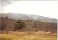
Elliott Knob in winter
-
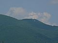
Radio towers below summit


