
Englewood, New Jersey facts for kids
Quick facts for kids
Englewood, New Jersey
|
||
|---|---|---|
|
City
|
||

Downtown Englewood
|
||
|
||

Location of Englewood in Bergen County highlighted in red (left). Inset map: Location of Bergen County in New Jersey highlighted in orange (right).
|
||

Census Bureau map of Englewood, New Jersey
<mapframe text="Interactive map of Englewood, New Jersey" zoom="8" width="250" height="250"> { "type": "ExternalData", "service": "geoshape", "ids": "Q986210" } </mapframe> |
||

Englewood, New Jersey
Location in Bergen County, New Jersey

Englewood, New Jersey
Location in New Jersey

Englewood, New Jersey
Location in the United States
|
||
| Country | ||
| State | ||
| County | Bergen | |
| Incorporated | March 17, 1899 | |
| Named for | Engle family or "English Neighborhood" |
|
| Government | ||
| • Type | Special charter | |
| • Body | City Council | |
| Area | ||
| • Total | 4.95 sq mi (12.82 km2) | |
| • Land | 4.92 sq mi (12.76 km2) | |
| • Water | 0.02 sq mi (0.06 km2) 0.46% | |
| Area rank | 279th of 565 in state 15th of 70 in county |
|
| Elevation | 43 ft (13 m) | |
| Population
(2020)
|
||
| • Total | 29,308 | |
| • Estimate
(2023)
|
29,624 | |
| • Rank | 83rd of 565 in state 6th of 70 in county |
|
| • Density | 5,950.9/sq mi (2,297.7/km2) | |
| • Density rank | 90th of 565 in state 26th of 70 in county |
|
| Time zone | UTC−05:00 (Eastern (EST)) | |
| • Summer (DST) | UTC−04:00 (Eastern (EDT)) | |
| ZIP Code |
07631
|
|
| Area code(s) | 201 | |
| FIPS code | 3400321480 | |
| GNIS feature ID | 0885209 | |
| Website | cityofenglewood.org | |

Englewood is a city located in Bergen County, in the state of New Jersey. It became an official city on March 17, 1899. This happened when parts of Ridgefield Township and Englewood Township joined together.
In 2020, Englewood had a population of 29,308 people. This was the highest number of people living in the city at one time. The population grew by over 2,000 people since the 2010 census.
Contents
History of Englewood
How Englewood Got Its Name
Englewood Township, which was the area before the city, likely got its name in 1859. Many believe it was named after the Engle family. The area was also known as the "English Neighborhood". This was because it was the first place on the New Jersey side of the Hudson River where people mainly spoke English. This happened after England took over New Netherland in 1664.
Other ideas for the name come from the Engle family and the many forests in the area. Some also think the name means "woody nook." A person named J. Wyman Jones helped convince people to choose "Englewood" when the city was formed. They chose it over other names like "Brayton" or "Paliscena."
Early Days: Native Americans and European Settlers
Before Europeans arrived, the Lenape Native Americans lived in the Englewood area. The Lenape here were part of the "turtle clan" and used a turtle as their symbol. About 2,000 Lenape lived in Englewood at first. However, their numbers dropped to about 50 by 1832 due to conflicts with European settlers.
In 1607, Henry Hudson explored the river now called the Hudson River. He claimed all the land around the river, including Englewood, for the Netherlands. This made Englewood part of New Netherland. But the Dutch did not settle much land north of what is now Hudson County. The tall New Jersey Palisades cliffs made it hard to expand on the west side of the Hudson River.

In 1664, the Dutch gave up New Netherland to England. After this, more people started to settle in the area. The English offered a lot of land. Many families, including English, Dutch, and Huguenot (French Protestants), moved to the area. During this time, it was known as the English Neighborhood.
Even today, some street names in Englewood show the different backgrounds of its first settlers. Names like Brinckerhoff, Van Brunt, and Lydecker are Dutch. Demarest and Lozier are French Huguenot. Moore, Lawrence, and Day are English.
Historic Places to Visit
Englewood has several places listed on the National Register of Historic Places. These sites are important parts of the city's past:
- John G. Benson House (60 Grand Avenue; added 1983)
- Thomas Demarest House (370 Grand Avenue; added 1983)
- Garret Lydecker House (228 Grand Avenue; added 1983)
- St. Paul's Episcopal Church (113 Engle Street; added 2014)
- Demott–Westervelt House (285 Grand Avenue; added 1983)
Geography and Location
Englewood covers about 4.95 square miles (12.82 square kilometers). Most of this area is land, with a small amount of water.
The city is next to several other towns in Bergen County. These include Bergenfield, Englewood Cliffs, Fort Lee, Leonia, Teaneck, and Tenafly.
Population Changes in Englewood
| Historical population | |||
|---|---|---|---|
| Census | Pop. | %± | |
| 1900 | 6,253 | — | |
| 1910 | 9,924 | 58.7% | |
| 1920 | 11,627 | 17.2% | |
| 1930 | 17,805 | 53.1% | |
| 1940 | 18,966 | 6.5% | |
| 1950 | 23,145 | 22.0% | |
| 1960 | 26,057 | 12.6% | |
| 1970 | 24,985 | −4.1% | |
| 1980 | 23,701 | −5.1% | |
| 1990 | 24,850 | 4.8% | |
| 2000 | 26,203 | 5.4% | |
| 2010 | 27,147 | 3.6% | |
| 2020 | 29,308 | 8.0% | |
| 2023 (est.) | 29,624 | 9.1% | |
| Population sources: 1900–1920 1900–1910 1900–1930 1900–2020 2000 2010 2020 |
|||
The population of Englewood has grown over the years. In 1900, about 6,253 people lived there. By 2020, the population had reached 29,308. This shows a steady increase in the number of residents.
In 2010, there were 27,147 people living in Englewood. The city is home to a diverse group of people. Many different backgrounds and cultures make up the community.
Sports and Recreation
Sports Clubs
The Englewood Field Club is a local sports club. It has tennis courts, a swimming pool, and an outdoor hockey rink.
Parks and Nature

MacKay Park is located on North Van Brunt Street. It offers an ice hockey rink, a pool, a walking path, and sports fields.
The Flat Rock Brook Nature Center is a special place in Englewood. It protects a part of the Palisades Forest. The center opened in 1973 and is 150 acres large. It has 3.6 miles of walking trails and several gardens, including a Butterfly Garden. Visitors can learn about the local ecosystem through exhibits and tours all year round.
Education in Englewood
Public Schools
The Englewood Public School District serves students from pre-kindergarten through twelfth grade. It has five schools. Students from Englewood Cliffs also attend Dwight Morrow High School in Englewood.
The schools in the district include:
- D. A. Quarles Early Childhood Center (PreK-K)
- Dr. John Grieco Elementary School (grades 1-2)
- Dr. Leroy McCloud School (grades 3-5)
- Janis E. Dismus Middle School (grades 6-8)
- Dwight Morrow High School / Academies @ Englewood (grades 9-12)
In 2009, Cleveland School was renamed Dr. Leroy McCloud School. This honored the district's first African-American principal.
Students in Bergen County can also attend special high school programs. These are offered by the Bergen County Technical Schools. They have campuses in Hackensack, Teterboro, and Paramus. Students apply to these programs, and their home school district covers the cost.
Englewood also has a charter school called Englewood on the Palisades Charter School. It serves students from Kindergarten to fifth grade.
Private Schools
Englewood is home to several private schools:
- Dwight-Englewood School serves students from pre-kindergarten through twelfth grade.
- Elisabeth Morrow School, founded in 1930, serves students from preschool through eighth grade.
- Moriah School of Englewood is a large Jewish day school. It serves students from preschool through eighth grade.
- Yeshiva Ohr Simcha serves high school students (grades 9-12) and has a postgraduate program.
St. Cecilia Interparochial School closed in 2011 due to fewer students. St. Cecilia High School, where Vince Lombardi coached football, closed in 1986.
Healthcare Services
- Englewood Hospital and Medical Center is on Engle Street. It is known for its heart care, bloodless surgery, and breast care programs.
- Lillian Booth Actors Home is a special home for entertainment and performing arts professionals who need assistance.
Transportation Options
Roads and Highways
_at_Exit_71_(Englewood)_on_the_border_of_Englewood_and_Leonia_in_Bergen_County,_New_Jersey.jpg)
Englewood has many miles of roads. Most are maintained by the city. Major highways serving Englewood include Interstate 95. This highway runs for a short distance near the city's southern border.
Other important roads include Route 4, Route 93, County Route 501, and County Route 505.

Public Transportation
Several NJ Transit bus lines serve Englewood. These buses connect the city to places like the Port Authority Bus Terminal in Midtown Manhattan and the George Washington Bridge Bus Station in uptown Manhattan. There are also local bus services.
The Erie Railroad used to have passenger train service in Englewood. This service started in 1859 and ended in 1966. The old station building at Depot Square is still there.
There is a plan called the Northern Branch Corridor Project. This project would extend the Hudson–Bergen Light Rail into Englewood. It would add new stations, including stops at Englewood Route 4 and Englewood Town Center. The line would end near Englewood Hospital. City leaders support this project because it could bring economic benefits.
Places of Worship
- Congregation Ahavath Torah is a Modern Orthodox synagogue in Englewood. It was founded in 1895.
- St. Paul's Episcopal Church is an Episcopal church in the city.
Notable People from Englewood
Images for kids
-
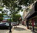
Downtown Englewood
-

Seal of Englewood
-
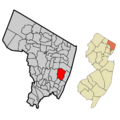
Location of Englewood in Bergen County
-
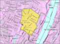
Census Bureau map of Englewood, New Jersey
See also
 In Spanish: Englewood (Nueva Jersey) para niños
