
English Neighborhood facts for kids
The English Neighborhood was an old name for a group of towns in eastern Bergen County, New Jersey. These towns were located between the Hudson River and the Hackensack River, near a smaller river called Overpeck Creek. Before the English took over, this area was part of a Dutch colony called New Netherland. Its main town, Bergen, was in what is now Jersey City. The Dutch word bergen means hills, which describes the area's geography. Earlier attempts by Dutch settlers to build towns here, like Achter Col and Vriessendael, faced problems. This was because of conflicts with the Lenape people, who lived there first. The Lenape groups in this area were known as the Hackensack and the Tappan.
Contents
How the English Neighborhood Got Its Name
After the British took control of the Dutch colony of New Netherland in 1664, the area became part of East Jersey. The British wanted more people to move there. So, they quickly divided the land and gave out many land titles. Some titles went to the Dutch people already living there. But many also went to English and Huguenot settlers. These new settlers came from Europe, New England, Long Island, or the West Indies.
On June 10, 1669, a man named Samuel Edsall received a large piece of land. This land was "between the Hudson River and Overpeck's Creek." It covered most of the area that would become the English Neighborhood. By 1675, people were already calling it the English Neighborhood.
Who Was Samuel Edsall?
Samuel Edsall was born in Reading, England, around 1630. He came to New Amsterdam (which is now New York City) when he was 18. He worked as a "bever maker," or a hatter, making hats from beaver fur. His business and his marriage helped him become a property owner. He lived in the Bergen Neck area and learned the Lenape language. He even helped translate for a land deal called the Newark Tract. After the British took over, he bought nearly 2,000 acres of land. This land stretched almost two and a half miles along the Hudson River, from Bulls Ferry to Overpeck Creek and the Hackensack River. His own farm was near what is now Palisades Park. Over time, he sold or leased parts of his large estate.
Counties and Townships Are Formed
In 1683, the area was divided into administrative districts called counties. Bergen County was created, covering the land between the Hudson and Hackensack rivers. Its southern border was Bergen Point, and its northern border was the new, sometimes unclear, state line with New York.
In 1693, Bergen County was split into two townships. The northern part became Hackensack Township. The southern part, which included the English Neighborhood, became Bergen Township. In 1710, the nearby village of Hackensack became the main town, or county seat, for Bergen County.
The English Neighborhood During the American Revolution
Before the American Revolutionary War, a liberty pole was put up at an important crossroads in the English Neighborhood. This pole was a symbol of freedom from British rule. However, the British Army soon took control of the area. This happened after George Washington and his army retreated from Fort Lee, passing through the English Neighborhood.
The Continental Army (the American army) stayed in the area to watch the British movements in New York. Because the English Neighborhood was between the two armies, there were many small battles and raids for supplies. These fights were sometimes called the Forage War. Major John André, a British officer who was later executed for working with Benedict Arnold, even wrote about the English Neighborhood in his poem The Cow Chase. In his poem, he talks about how Anthony Wayne's plan to get cows from Bergen was stopped.
How the English Neighborhood Became Modern Towns
On March 22, 1871, Hackensack Township was divided into three new townships. Each of these new townships stretched from the Hudson River in the east to the Hackensack River in the west. The southernmost part, which was the English Neighborhood, became Ridgefield Township.
In 1878, a new law allowed smaller towns, called boroughs, to be formed within townships. This led to Ridgefield Township being divided many times. New towns created from Ridgefield Township included:
- Bogota (1894)
- Leonia (1894)
- Undercliff (1894), later renamed "Edgewater" in 1899
- Fairview (1894)
- Part of Teaneck (1895)
- Cliffside Park (1895)
- Part of Englewood (1895)
- Palisades Park (1899)
The creation of Fort Lee, New Jersey on April 18, 1904, finally ended Ridgefield Township.
Growth and Transportation
The area grew a lot as its small villages became larger towns. Farmland was turned into suburbs. This growth was helped by the expansion of the railway system in the late 1800s. The Erie Railroad ran trains to its Pavonia Terminal on the Hudson waterfront. Later, people could connect to Manhattan by bus through the Lincoln Tunnel. The last train on the Northern Branch from the terminal to this area ran on December 12, 1958. Today, there are plans to bring back train service with an extension of the Hudson Bergen Light Rail line. This project is known as the Northern Branch Corridor Project.
Where the Name Still Lives On
Even though the term "English Neighborhood" is not widely used anymore, some places still have the name.
- The Dutch Reformed Church in the English Neighborhood in Ridgefield was built in 1793. Its church group started in 1770.
- In Fairview, the English Neighborhood Park and the English Neighborhood Public School still use the name.
- The Union School of the English Neighborhood, which was moved from its original spot, is an important landmark in Englewood.
- The names of Englewood and Englewood Cliffs themselves come from a changed version of "English Neighborhood."
Images for kids
-
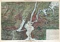
In 1871 Harpers Weekly View or Map of New York City from a Balloon the area is still described as the English Neighborhood

