
Eucla, Western Australia facts for kids
Quick facts for kids EuclaWestern Australia |
|||||||||
|---|---|---|---|---|---|---|---|---|---|
.jpg)
Eucla Motor Hotel, 2017
|
|||||||||

Eucla
Location in Western Australia
|
|||||||||
| Established | 1870s (gazetted in 1885) | ||||||||
| Postcode(s) | 6443 | ||||||||
| Elevation | 93 m (305 ft) | ||||||||
| Area | [convert: needs a number] | ||||||||
| Time zone | CWST (unofficial) (UTC+8:45) | ||||||||
| Location |
|
||||||||
| LGA(s) | Shire of Dundas | ||||||||
| State electorate(s) | Kalgoorlie | ||||||||
| Federal Division(s) | O'Connor | ||||||||
|
|||||||||
Eucla is a small town in Western Australia. It is the easternmost place in the state. You can find it in the Goldfields-Esperance region. Eucla sits along the Eyre Highway, about 11 kilometres (7 miles) west of the South Australian border. In 2016, only 53 people lived there.
Eucla is special because it's the only spot on the Eyre Highway in Western Australia where you can see the Great Australian Bight. This is thanks to its high position next to the Eucla Pass. Here, the highway climbs up from the flat area called Roe Plains.
Contents
Discovering Eucla's Past
The name Eucla might come from an Aboriginal word, "Yinculyer." Some believe it means "the rising of the planet Venus". Europeans started using the name for this area before 1867.
Early Explorers and Settlements
In 1841, explorers Eyre and Baxter were the first Europeans to visit Eucla. Later, in 1867, a port was officially declared there. In 1870, John Forrest camped at the spot for almost two weeks.
A big step for Eucla happened in 1873. Land was set aside for a telegraph station. This station was part of a new telegraph line. This line connected Albany to Adelaide.
The Important Telegraph Station
When the telegraph line opened in 1877, Eucla became very important. It was a key "repeater station." This meant messages had to be re-sent from here. Why? Because South Australia used a different Morse code than Western Australia. Eucla helped switch between the two codes.
To get supplies, a jetty (a small pier) and a tram line were built. Ships brought goods in by sea. The town officially became a township in 1885. Eucla was at its busiest in the 1920s. But then, a new telegraph line was built further north in 1929. This new line followed the Trans-Australian Railway.
Eucla's Changing Landscape
In the 1890s, a huge rabbit plague hit the area. The rabbits ate many plants on the Delisser Sandhills. This made the sand dunes unstable. Large sand drifts then started to cover the town.
Because of the moving sand, the original town had to be left behind. A new town was built about 4 kilometres (2.5 miles) north. This new spot was higher up on the cliffs. The old telegraph station ruins are still there among the dunes. They are a popular place for tourists to visit.
Many early farmers and telegraph workers were buried in Eucla. But as the sand dunes moved, some gravestones were taken to the Eucla museum. In 1898, 96 people lived in the town.
Understanding Eucla's Weather
Eucla has a mild semi-arid climate. This means it has mild winters and warm summers. However, it can get very hot days. These hot days often come with strong, hot winds from the Great Victoria Desert.
Even though it's close to a desert, Eucla gets a fair bit of moisture. This is because it's near the ocean. The air is often quite humid all year. Eucla only has about 94 clear days each year. This is less than some wetter cities on Australia's east coast.
Temperature and Rainfall
The average highest temperatures are around 25-26°C (77-79°F) from December to March. In July, the average high is about 18°C (64°F). Eucla gets about 273.5 mm (10.8 inches) of rain each year. This rain is spread out evenly. Monthly rainfall ranges from 15.2 mm (0.6 inches) in January to 31.3 mm (1.2 inches) in May. The hottest day ever recorded was 48.2°C (118.8°F) on January 4, 2013.
| Month | Jan | Feb | Mar | Apr | May | Jun | Jul | Aug | Sep | Oct | Nov | Dec | Year |
|---|---|---|---|---|---|---|---|---|---|---|---|---|---|
| Record high °C (°F) | 48.2 (118.8) |
47.4 (117.3) |
44.2 (111.6) |
40.4 (104.7) |
36.5 (97.7) |
33.3 (91.9) |
28.3 (82.9) |
33.1 (91.6) |
40.0 (104.0) |
42.9 (109.2) |
44.5 (112.1) |
47.4 (117.3) |
48.2 (118.8) |
| Mean daily maximum °C (°F) | 25.9 (78.6) |
25.7 (78.3) |
25.2 (77.4) |
23.6 (74.5) |
21.1 (70.0) |
18.7 (65.7) |
18.0 (64.4) |
19.2 (66.6) |
21.4 (70.5) |
23.2 (73.8) |
24.3 (75.7) |
24.9 (76.8) |
22.6 (72.7) |
| Mean daily minimum °C (°F) | 16.6 (61.9) |
17.0 (62.6) |
15.9 (60.6) |
13.4 (56.1) |
10.6 (51.1) |
8.2 (46.8) |
7.0 (44.6) |
7.5 (45.5) |
9.2 (48.6) |
11.3 (52.3) |
13.4 (56.1) |
15.0 (59.0) |
12.1 (53.8) |
| Record low °C (°F) | 3.5 (38.3) |
7.8 (46.0) |
6.7 (44.1) |
2.0 (35.6) |
0.0 (32.0) |
0.0 (32.0) |
−0.6 (30.9) |
0.0 (32.0) |
1.1 (34.0) |
1.5 (34.7) |
4.1 (39.4) |
6.9 (44.4) |
−0.6 (30.9) |
| Average precipitation mm (inches) | 15.2 (0.60) |
18.4 (0.72) |
22.8 (0.90) |
26.7 (1.05) |
31.3 (1.23) |
30.1 (1.19) |
25.3 (1.00) |
25.9 (1.02) |
22.5 (0.89) |
18.3 (0.72) |
18.3 (0.72) |
18.4 (0.72) |
273.2 (10.76) |
| Average precipitation days (≥ 0.2mm) | 3.6 | 4.7 | 6.3 | 7.7 | 10.3 | 10.5 | 10.2 | 9.8 | 8.2 | 6.5 | 5.5 | 4.8 | 88.1 |
| Average relative humidity (%) | 64 | 65 | 65 | 62 | 59 | 59 | 58 | 57 | 57 | 59 | 61 | 63 | 61 |
| Source: Australian Bureau of Meteorology | |||||||||||||
Eucla Today: A Stopping Point

Eucla is the biggest place to stop between Norseman and Penong. Many travellers on the Eyre Highway stop here. It has a hotel, a restaurant, and a police station. There's also a golf club about 7 kilometres (4.3 miles) north.
You can visit a museum dedicated to the Old Telegraph Station. There is also a weather station. Fishing is another popular activity. A monument called the Travellers Cross remembers local people who have passed away.
Nearby Border Village
The small town of Border Village is 12 kilometres (7.5 miles) east of Eucla. It's in South Australia. This village was mainly set up as a checkpoint. It helps stop certain farm products from crossing the border. Border Village also has a roadhouse and a caravan park.
Understanding Eucla's Time Zone
Eucla and the nearby areas like Mundrabilla and Madura use a special time zone. It's called Central Western Time Zone, or UTC+8:45. This means it's 8 hours and 45 minutes ahead of Coordinated Universal Time.
Even though this time zone isn't officially recognized by the government, everyone in this area uses it. It stops just east of Caiguna.
Getting Around Eucla
Eucla is an important stop along the Eyre Highway. This highway is a major road for travel.
In 2005, a bus company called Greyhound Australia stopped its service. This service used to cross the Nullarbor Plain. They stopped because fuel prices went up and fewer people were using the buses.
Images for kids
-
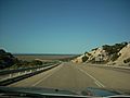
Eucla Pass
-
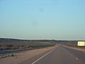
Eucla Pass from the west
-
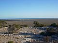
Eucla Pass looking toward the south coast


