Penong, South Australia facts for kids
Quick facts for kids PenongSouth Australia |
|||||||||||||||
|---|---|---|---|---|---|---|---|---|---|---|---|---|---|---|---|

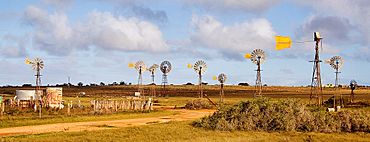
Windmills adjacent to Penong: each is privately owned and supplies houses and farms with water from the Anjutabie Basin.
|
|||||||||||||||
| Established | 28 April 1892 (town) 8 February 2001 (locality) |
||||||||||||||
| Postcode(s) | 5690 | ||||||||||||||
| Time zone | ACST (UTC+9:30) | ||||||||||||||
| • Summer (DST) | ACST (UTC+10:30) | ||||||||||||||
| Location |
|
||||||||||||||
| LGA(s) | Pastoral Unincorporated Area | ||||||||||||||
| Region | Eyre Western | ||||||||||||||
| County | Kintore | ||||||||||||||
| State electorate(s) | Flinders | ||||||||||||||
| Federal Division(s) | Grey | ||||||||||||||
|
|||||||||||||||
|
|||||||||||||||
| Footnotes | Adjoining localities | ||||||||||||||
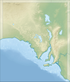
Penong (pronounced p(ə)-NONG) is a small town in the far west of South Australia. It is located on the Nullarbor Plain, a very flat and dry area. Penong is about 616 kilometers (383 miles) north-west of Adelaide, the state capital.
This town is a popular stop for people traveling on the Eyre Highway. This highway connects Ceduna to Western Australia. Penong is about 400 kilometers (250 miles) from the Western Australian border.
In 2016, a survey showed that Penong and the nearby farming area of Bookabie had 289 people living there. Bookabie is about 35 kilometers (22 miles) west of Penong.
Penong is also close to some interesting natural spots. To its south, you'll find Cactus Beach, which is famous for surfing. Nearby is Lake MacDonnell, which has the largest gypsum field in the Southern Hemisphere. Gypsum is a mineral used in building materials.
Contents
History of Penong
The name Penong likely comes from an Aboriginal word. It might mean "rockhole" or be a changed version of poomong, which means "tea tree".
Early Settlement and Town Growth
Farmers started settling around Penong in the late 1800s. The town of Penong was officially created on April 28, 1892. Back then, the roads were just rough tracks.
It was hard to transport goods until the railway arrived in 1924. The railway helped farmers send their grain and wool to Port Lincoln, which was 426 kilometers (265 miles) away. Penong was one of only three towns on the Eyre Peninsula that existed before the railway came. The train services stopped in 1997.
Modern Locality Boundaries
The official boundaries for the Penong area were set on February 8, 2001. More land, including the Chadinga Conservation Park, was added to the Penong locality on April 26, 2013.
Farming and Water Supply
Penong is located where there is just enough rainfall for farming. The nearby town of Ceduna gets only about 296.7 millimeters (11.7 inches) of rain each year. This means that getting enough water is very important for the people in Penong.
The town is known for its many privately owned windmills. These windmills pump water from the Anjutabie Basin to supply homes and farms. In 1923, the South Australian Railways built huge underground concrete tanks. These tanks could hold 4.54 million liters (1 million gallons) of water. They were used to collect rainwater that ran off the ground.
Community Life
The people of Penong are very active in their community. Many participate in activities with the West Coast Football Club, which is based in Ceduna. Parents at Penong Primary School often raise money for events like Relay for Life.
In 2019, the Penong Progress Association received money from the government. This funding helped them build a shaded shelter and seating for families. This was part of their skate park project, making public spaces better for everyone. A popular yearly event is the Penong Race Club's Far West Farmers Penong Cup horse race. This exciting race meeting happens every March.
How Penong is Governed
Penong is part of a larger area called the Pastoral Unincorporated Area of South Australia. This means it's not part of a local council like a city or town. Instead, a state government agency called the Outback Communities Authority provides local services.
For federal elections, Penong is in the Division of Grey. For state elections, it is in the Electoral district of Flinders.
 | James Van Der Zee |
 | Alma Thomas |
 | Ellis Wilson |
 | Margaret Taylor-Burroughs |


