
First Battle of Newtonia Historic District facts for kids
Quick facts for kids |
|
|
First Battle of Newtonia Historic District
|
|

Location in Missouri

Location in the United States
|
|
| Nearest city | Newtonia, Missouri |
|---|---|
| Area | 152.3 acres (61.6 ha) |
| NRHP reference No. | 04000697 |
| Added to NRHP | December 23, 2004 |
The First Battle of Newtonia Historic District is a special place near Newtonia, Missouri. It protects the area where the First Battle of Newtonia happened in 1862. This was an important fight during the American Civil War.
In this battle, soldiers from the Confederate side, led by Colonels Douglas H. Cooper and Joseph O. Shelby, won against a Union army. The Union forces were commanded by Brigadier General Frederick Salomon. The historic district has some buildings from the Civil War time. It also includes the Mathew H. Ritchey House, which is a historic building listed on its own.
Contents
The Battle of Newtonia
In September 1862, a Union army group moved south into southwestern Missouri. This group was led by Brigadier General James G. Blunt. The town of Newtonia was held by Confederate soldiers. These included Native Americans who supported the Confederacy, led by Colonel Douglas H. Cooper. There were also cavalry (soldiers on horseback) led by Colonel Joseph O. Shelby. Colonel Cooper was in charge overall because he had more experience.
First Contact
General Blunt's lead group, commanded by Brigadier General Frederick Salomon, found out the Confederates were in Newtonia. A small Union scouting team had a quick fight with some of Shelby's cavalry near Granby on September 29. The next day, General Salomon's main force moved towards Newtonia. They soon met the main Confederate army.
The Fight Begins
The battle started with an artillery duel. This means both sides fired cannons at each other. The Confederate cannons began to run out of ammunition. Then, General Salomon ordered the 9th Wisconsin Infantry to move around the side of the Confederate front line. This move is called a flank attack.
Confederate Counterattack
The Confederate front line started to break apart. But then, some of Shelby's cavalry charged and stopped the Union advance. After this, Shelby's cavalry and Cooper's Native American soldiers charged together. They broke through a second line that the Union forces had formed.
Union Retreat
The Union forces had to retreat more than ten miles to Sarcoxie. The Confederates lost about 78 soldiers in the battle. The Union forces lost about 245 soldiers. Even though the Confederates won, their position was not safe. General Salomon's group was only a small part of a much larger Union army. Because of this, the Confederates decided to leave Missouri.
Newtonia Historic District

The First Battle of Newtonia Historic District was created in 2004. Its purpose is to protect the place where the battle happened. It is listed on the National Register of Historic Places, which means it's a very important historical site.
Key Features of the District
The main parts of the district are five important areas. These are called "contributing resources." The Mathew H. Ritchey House is also part of the district, but it's listed separately. The five main areas are:
- The battlefield itself.
- A stream called Newtonia Branch.
- The historic Newtonia road.
- A barnyard that belonged to the Ritchey House.
- A cemetery from the Civil War time.
The district covers about 152.3 acres. Most of the buildings there today were built after the battle. Some stone walls that were there during the fighting are gone now. However, the overall look and feel of the battlefield have not changed much since 1862. Besides the five main areas, there are 29 other buildings in the district. These were built after the battle and are mostly homes from the 1900s.
Historic Locations within the District
The cemetery in the district has over 600 graves. Some of these graves date back to 1858. Nine of the burials are directly linked to the American Civil War. The Ritchey barn was destroyed in the late 1800s. But the place where the barnyard was is still protected in the district. Archaeology (studying old things found in the ground) has shown that fighting happened in the barnyard area. Old fences at the barnyard site were used by soldiers for protection during the battle.
A part of Newtonia Branch, a historic stream, is also protected. So is a section of an old road called Neosho Road, which is now named Mill Street. The Mathew H. Ritchey House is also in the district. This house was built in the 1840s by the person who founded Newtonia. The Ritchey House and a family cemetery nearby were listed on the National Register of Historic Places in 1978.
Images for kids
-
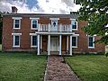
The Mathew H. Ritchey House

